Good morning.
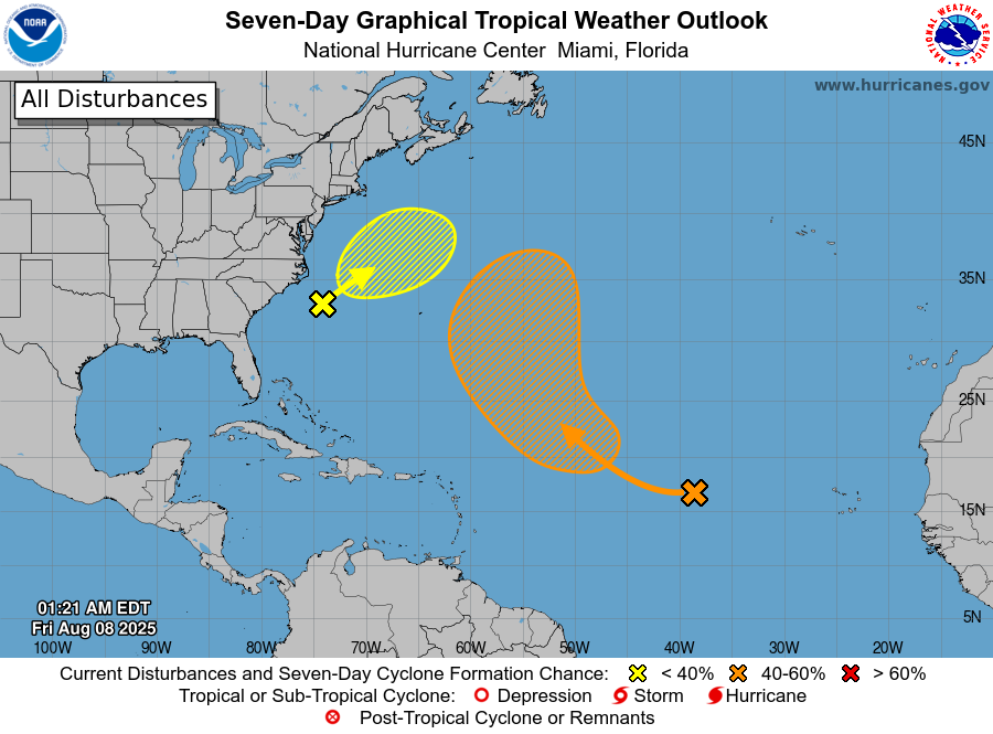
Just a quick update. As expected the 2025 tropical season has been off to a slow start due to large amounts of Sharan dust and shear however things are starting to change. There are currently 2 potential systems out there however neither poses a threat to the US.
The main things to note, see graphic below, are that the Saharan dust and dry air continue to cover a large part of the Tropical Atlantic however it's breadth is starting to thin.
Next notice on the surface map that high pressure that had been centered over the central Gulf and Florida most of the summer to date, has now shifted westward and the Bermuda High has shifted westward opening a window from the tropics into Florida. This is why we have been seeing more rainfall the past few days.
Next notice that wind shear has markedly decreased across the Caribbean and the Western Atlantic. Once the Saharan layer further erodes we are likely to see an uptick in storms. Hopefully the current dust will delay thing until the window moves away from Florida.
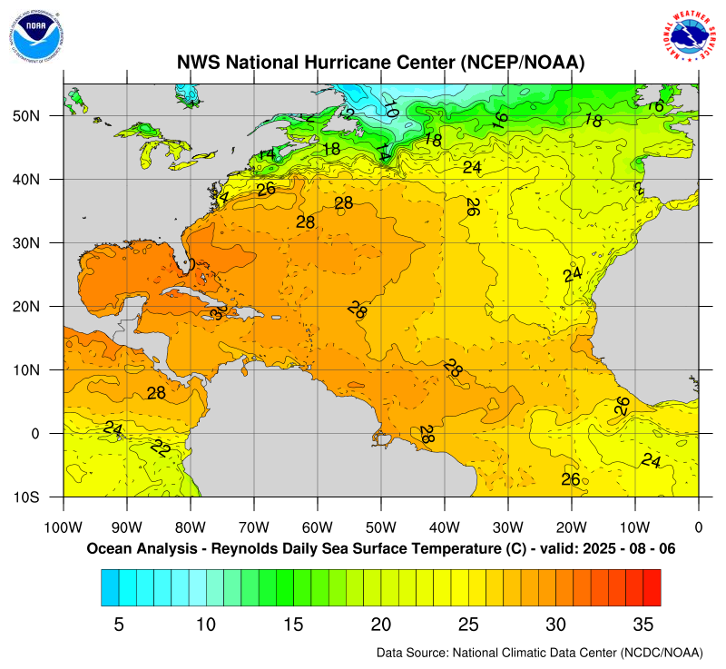
Next notice sea surface temperatures and heat content. The Caribbean the Gulf and the Bahamas currently have the warmest waters. The eastern Atlantic waters are relative cooler which will hopefully lead to fewer Cape Verde storms this year.
The Caribbean and Gulf season usually starts mid-late September thru October.
We currently look good but in a couple of weeks things may change. I'll be watching.
Until next time,
Matt.
Just a quick update. As expected the 2025 tropical season has been off to a slow start due to large amounts of Sharan dust and shear however things are starting to change. There are currently 2 potential systems out there however neither poses a threat to the US.
The main things to note, see graphic below, are that the Saharan dust and dry air continue to cover a large part of the Tropical Atlantic however it's breadth is starting to thin.
Next notice on the surface map that high pressure that had been centered over the central Gulf and Florida most of the summer to date, has now shifted westward and the Bermuda High has shifted westward opening a window from the tropics into Florida. This is why we have been seeing more rainfall the past few days.
Next notice that wind shear has markedly decreased across the Caribbean and the Western Atlantic. Once the Saharan layer further erodes we are likely to see an uptick in storms. Hopefully the current dust will delay thing until the window moves away from Florida.
Next notice sea surface temperatures and heat content. The Caribbean the Gulf and the Bahamas currently have the warmest waters. The eastern Atlantic waters are relative cooler which will hopefully lead to fewer Cape Verde storms this year.
The Caribbean and Gulf season usually starts mid-late September thru October.
We currently look good but in a couple of weeks things may change. I'll be watching.
Until next time,
Matt.