Good morning.
The Florida Panhandle and the Panama City area in particular are still reeling from the effects of Hurricane Michael. Michael was an unprecedented storm in many ways. Most notable is that it continued to intensify in spite of significant shear as if there were none. Hurricane Matthew did the same thing 2 years ago when it was off the northern coast of South America. Storms can only do that for a limited time, during periods of steady intensification with a small eye where the up flow and outflow are strong enough to negate the affects of the shear. Once they stop intensifying they go through eye wall replacement cycles and often, at least temporarily, weaken.
On Wednesday when the shear lessened it really exploded.
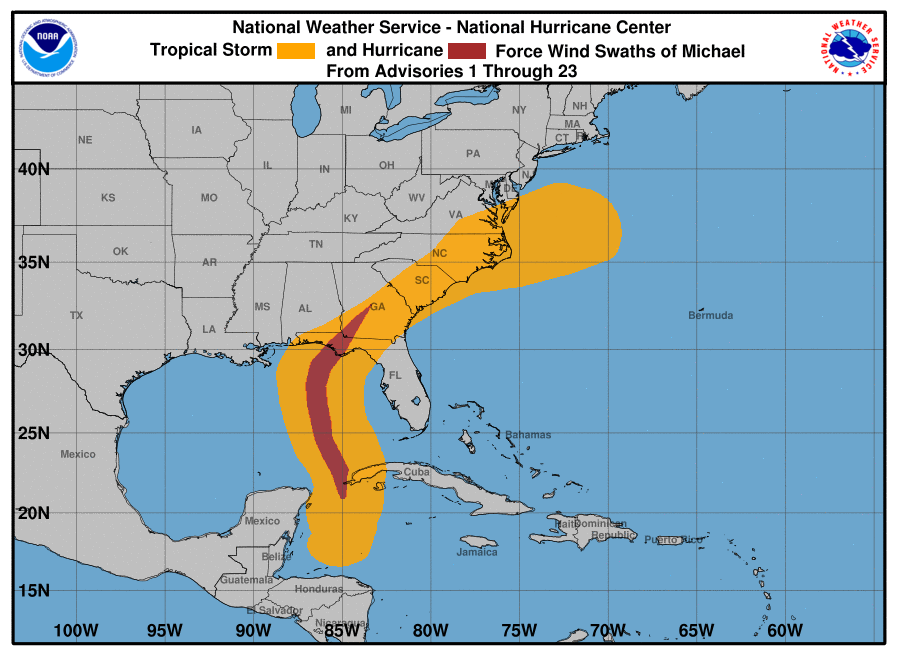
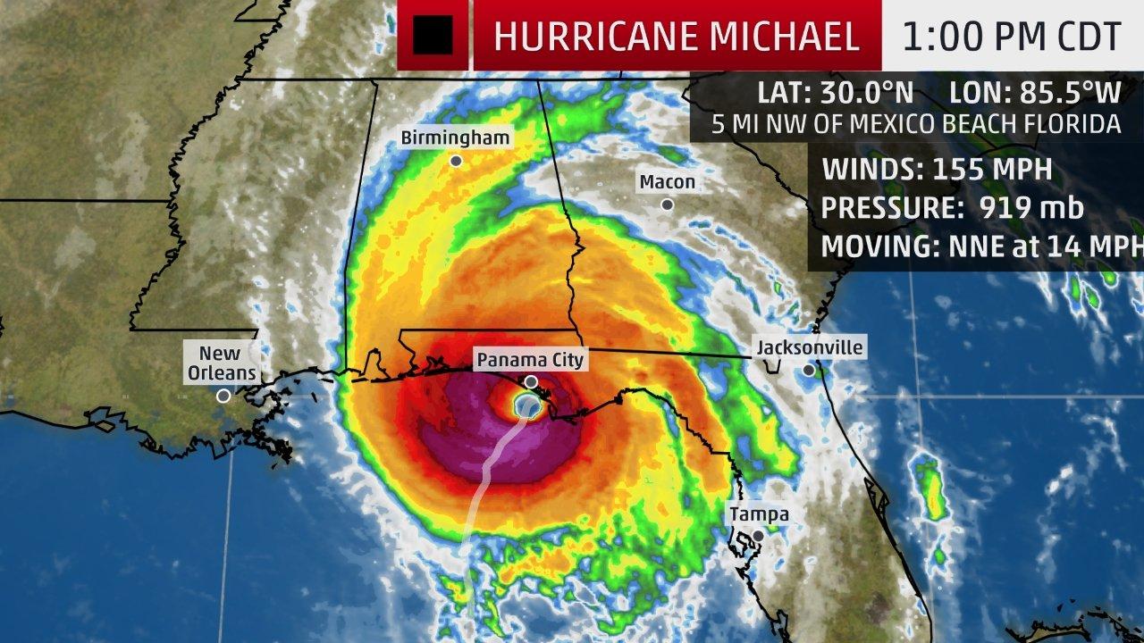
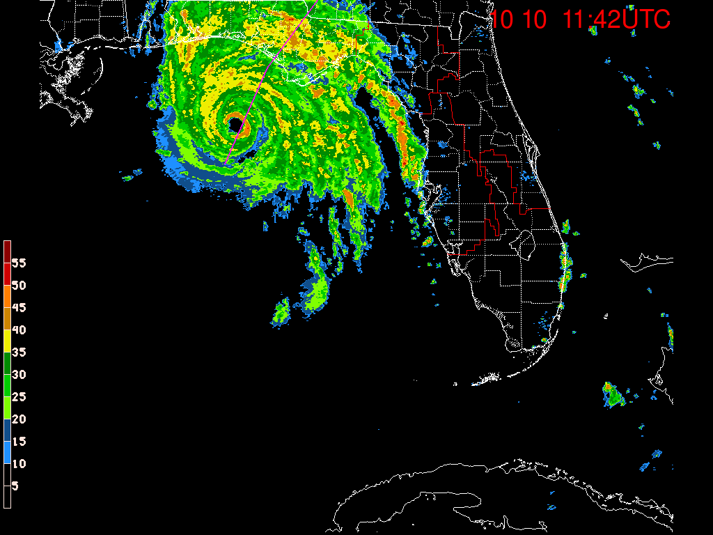
Below is Michaels Wind History Map, an infrared image with its vital statistics just prior to landfall, as well as Tallahassee Radar leading up to landfall. Look at the radar loop closely and you will see a very interesting feature. Notice how steady the eye is leading to landfall. There almost no wobble at all. This can only occur in a very intense, symmetric storm in the absence of shear. It is very rare to see. It happened with Hurricane Andrew in 1992 and with Hurricane Haiyon in the Pacific.
Elsewhere things in the tropics are settling down, Leslie is racing toward North Africa where it should dissipate off the coast and Nadine is expected to dissipate in 1-2 days. Cold fronts should start to pour into the US which should start to cool the waters down. Hopefully there will be no more US land falling systems this year.
Until next time, Matt.
PS. When you have a chance relook at my Preseason Forecast from April 27th, 2018.
The Florida Panhandle and the Panama City area in particular are still reeling from the effects of Hurricane Michael. Michael was an unprecedented storm in many ways. Most notable is that it continued to intensify in spite of significant shear as if there were none. Hurricane Matthew did the same thing 2 years ago when it was off the northern coast of South America. Storms can only do that for a limited time, during periods of steady intensification with a small eye where the up flow and outflow are strong enough to negate the affects of the shear. Once they stop intensifying they go through eye wall replacement cycles and often, at least temporarily, weaken.
On Wednesday when the shear lessened it really exploded.
Below is Michaels Wind History Map, an infrared image with its vital statistics just prior to landfall, as well as Tallahassee Radar leading up to landfall. Look at the radar loop closely and you will see a very interesting feature. Notice how steady the eye is leading to landfall. There almost no wobble at all. This can only occur in a very intense, symmetric storm in the absence of shear. It is very rare to see. It happened with Hurricane Andrew in 1992 and with Hurricane Haiyon in the Pacific.
Elsewhere things in the tropics are settling down, Leslie is racing toward North Africa where it should dissipate off the coast and Nadine is expected to dissipate in 1-2 days. Cold fronts should start to pour into the US which should start to cool the waters down. Hopefully there will be no more US land falling systems this year.
Until next time, Matt.
PS. When you have a chance relook at my Preseason Forecast from April 27th, 2018.