Good morning.
Since yesterday a few interesting things have developed regarding Elsa.
Elsa now moving quickly to the WNW at 28 mph and is a little ahead of yesterday's NHC forecast but is currently on their track.
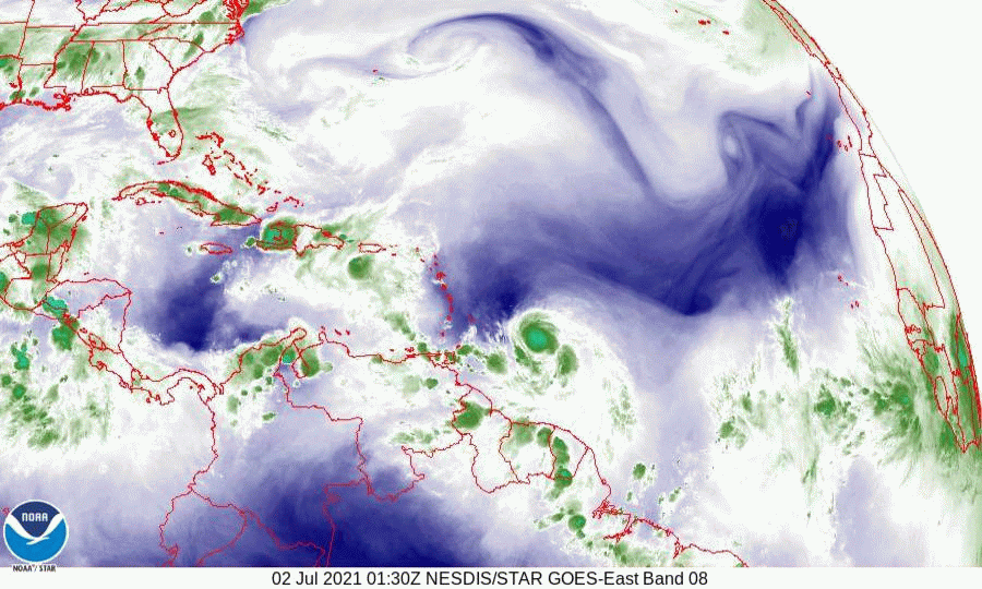
If you look at the Water Vapor Loop below you will notice a few things. First is that Elsa has become better organized and is moving steadily and symmetrically to the WNW. Next the upper level low is still in the central Gulf of Mexico. Next and most importantly see a cold front across the SE US pushing slowly to the SE. This will be a key factor in determining where Elsa will go.
If you look at the Models from last night, which have not changed this morning, you will see that they are all over the place. Currently ALL tracks for Elsa are low confidence tracks. The NHC is currently using the consensus of the European models for their track however do not be surprised if a dramatic shift should occur. If you look at the Surface Map below you will notice when compared to yesterday's, the High pressure in the Western Atlantic has shifted a little eastward and the isobars over Cuba, the Yucatan Channel and Florida have widened. This is in response the approaching cold front across the SE US. It is not stationary and if it should get far enough south a further deflection to the east is possible. Note these shifts are temporary and timing will be key.
If you look at the isobar that Elsa is on, on the close up Surface Map, you will see that it take it into Hispaniola. Note this is north of the NHC track. A key for South Florida will be if Elsa tracks south of Hispaniola, vs through it and how much land interactions occur between it and Hispaniola and Cuba. If it should track across Hispaniola and emerge on its north coast a track thru the Bahamas and east of Florida and missing the US would become more likely. If it moves south of Hispaniola and Cuba a track into the West Coast of Florida would become more likely. If it should get south of Cuba it should slow dramatically and if that happens it will give time for the environmental conditions to change. This is what is leading to the marked uncertainty in Elsa's forecast.
Short term as stated above the key will be just what happens tomorrow afternoon and night with regards to Elsa and Hispaniola.
Until next time,
Matt.
Since yesterday a few interesting things have developed regarding Elsa.
Elsa now moving quickly to the WNW at 28 mph and is a little ahead of yesterday's NHC forecast but is currently on their track.
If you look at the Water Vapor Loop below you will notice a few things. First is that Elsa has become better organized and is moving steadily and symmetrically to the WNW. Next the upper level low is still in the central Gulf of Mexico. Next and most importantly see a cold front across the SE US pushing slowly to the SE. This will be a key factor in determining where Elsa will go.
If you look at the Models from last night, which have not changed this morning, you will see that they are all over the place. Currently ALL tracks for Elsa are low confidence tracks. The NHC is currently using the consensus of the European models for their track however do not be surprised if a dramatic shift should occur. If you look at the Surface Map below you will notice when compared to yesterday's, the High pressure in the Western Atlantic has shifted a little eastward and the isobars over Cuba, the Yucatan Channel and Florida have widened. This is in response the approaching cold front across the SE US. It is not stationary and if it should get far enough south a further deflection to the east is possible. Note these shifts are temporary and timing will be key.
If you look at the isobar that Elsa is on, on the close up Surface Map, you will see that it take it into Hispaniola. Note this is north of the NHC track. A key for South Florida will be if Elsa tracks south of Hispaniola, vs through it and how much land interactions occur between it and Hispaniola and Cuba. If it should track across Hispaniola and emerge on its north coast a track thru the Bahamas and east of Florida and missing the US would become more likely. If it moves south of Hispaniola and Cuba a track into the West Coast of Florida would become more likely. If it should get south of Cuba it should slow dramatically and if that happens it will give time for the environmental conditions to change. This is what is leading to the marked uncertainty in Elsa's forecast.
Short term as stated above the key will be just what happens tomorrow afternoon and night with regards to Elsa and Hispaniola.
Until next time,
Matt.