Good morning.
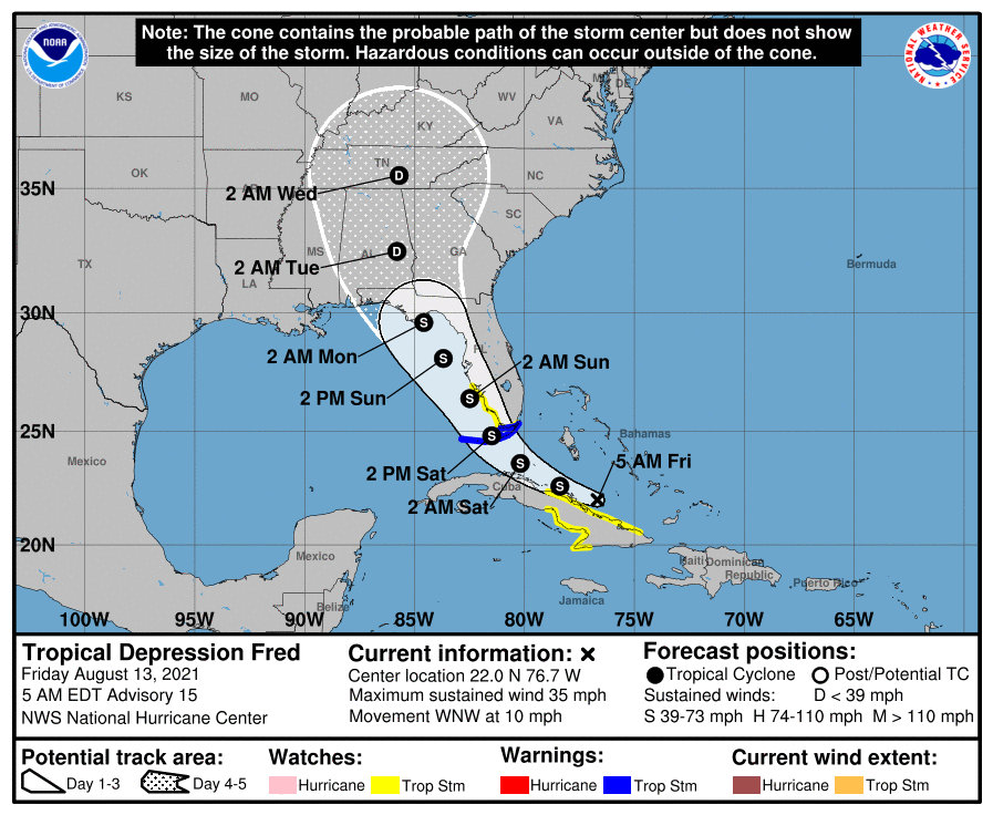
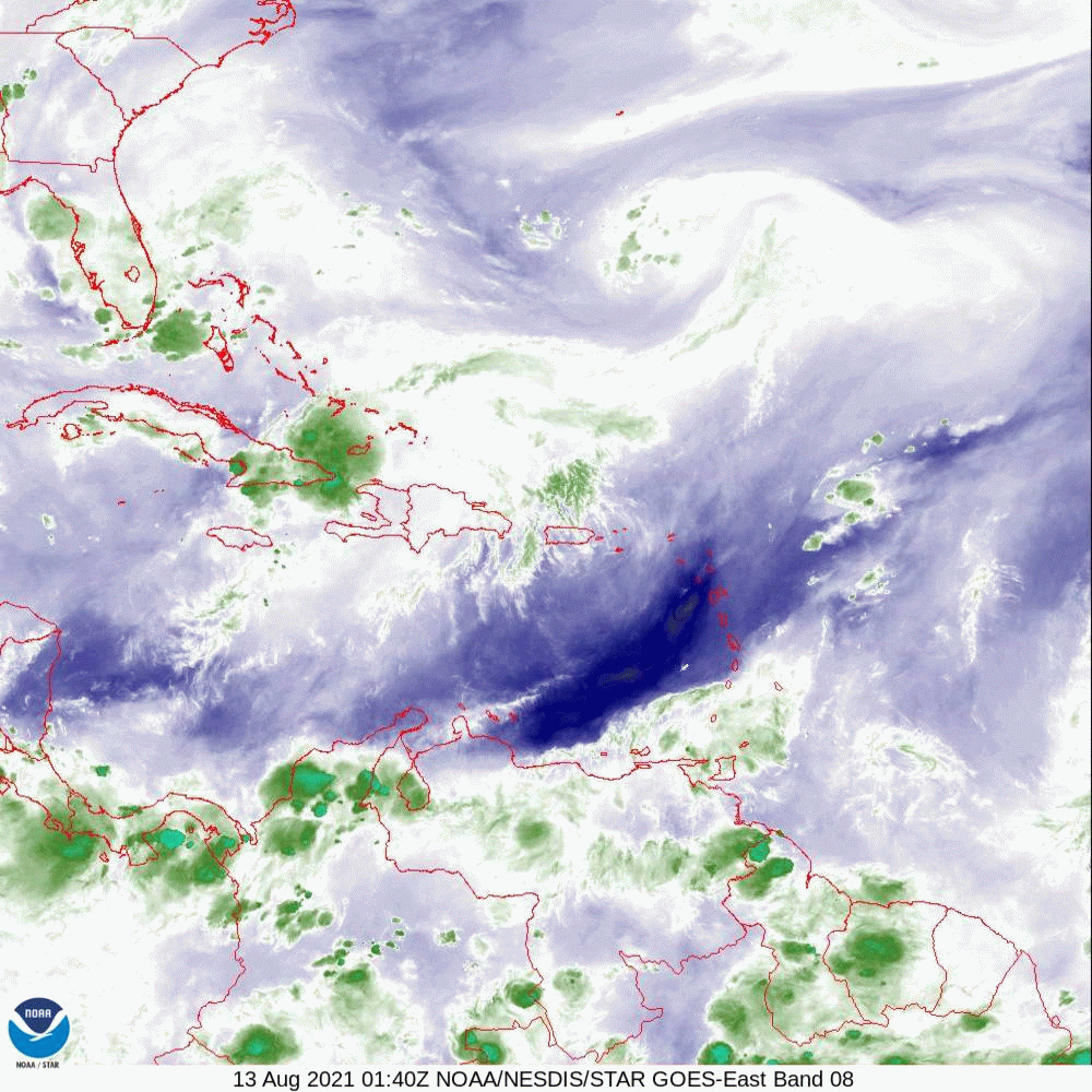
At 5 AM TD Fred was located along the northern Coast of Cuba. Over the past 3 days Fred's track has changed little. Fred remains poorly organized with no weather near its center.
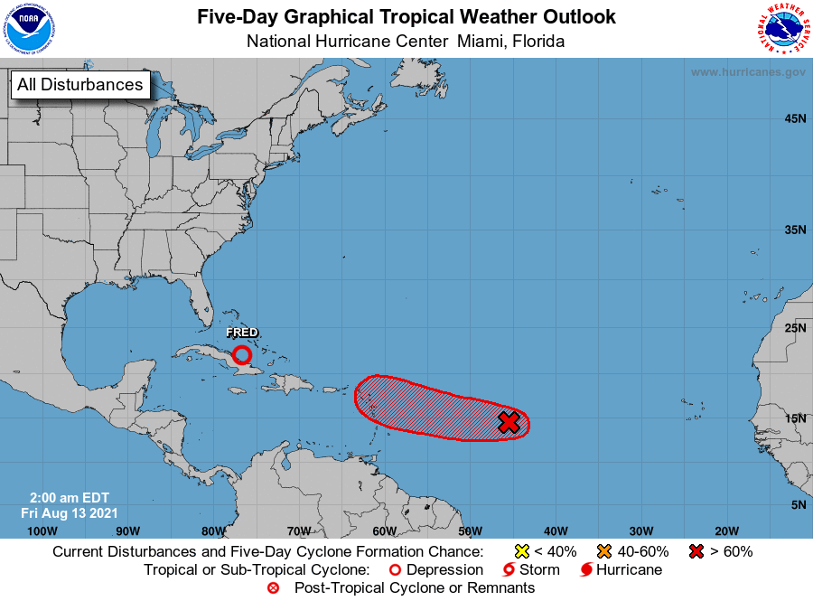
If you look at the Water Vapor Loops below you will notice several features. First Invest 95 moving WNW across the Central Tropical Atlantic. It will probably become our next tropical storm. On its current trajectory it looks like it will pass to the north of the Caribbean and likely miss Florida. Next is the upper level low south of Bermuda now appears to be moving SE. This will hopefully help Invest 95 to move more northwesterly. Next is the upper level low near Florida that I've been talking about for the past 3 days. It first was over Andros Island, yesterday morning over North Florida and it now appears to be just off the SW Florida coast and appears to be making a loop and I suspect is now heading SE and soon to be eastward. Just where this is in relation to Fred when it approaches Florida will be key. If it remains where it is and takes Fred head on it will significantly weaken or take out Fred. (appears unlikely as I think its moving). If it moves east of Fred it will tend to deflect Fred further west. (What I suspect will happen.) If it moves west of Fred it could deflect him eastward, closer to the West Coast of FL.
My current track is unchanged taking Fred near Key West and then in the direction of St Vincent's Island, just east of Panama City. Fred is anticipated to be a minimal Tropical storm when it approaches the Keys and the Panhandle. It currently has very little weather associated with it. The rain we had last night and will get today is related to the upper level low that I've been talking about.
Due to that ULL and the moisture associated with Fred we should see increased shower activity tonight and tomorrow but I do not anticipate a rain event for SE FL. Wind forecast is as stated previously. Not much. The Florida Panhandle will probably get more rain.
Until next time.
Matt.
At 5 AM TD Fred was located along the northern Coast of Cuba. Over the past 3 days Fred's track has changed little. Fred remains poorly organized with no weather near its center.
If you look at the Water Vapor Loops below you will notice several features. First Invest 95 moving WNW across the Central Tropical Atlantic. It will probably become our next tropical storm. On its current trajectory it looks like it will pass to the north of the Caribbean and likely miss Florida. Next is the upper level low south of Bermuda now appears to be moving SE. This will hopefully help Invest 95 to move more northwesterly. Next is the upper level low near Florida that I've been talking about for the past 3 days. It first was over Andros Island, yesterday morning over North Florida and it now appears to be just off the SW Florida coast and appears to be making a loop and I suspect is now heading SE and soon to be eastward. Just where this is in relation to Fred when it approaches Florida will be key. If it remains where it is and takes Fred head on it will significantly weaken or take out Fred. (appears unlikely as I think its moving). If it moves east of Fred it will tend to deflect Fred further west. (What I suspect will happen.) If it moves west of Fred it could deflect him eastward, closer to the West Coast of FL.
My current track is unchanged taking Fred near Key West and then in the direction of St Vincent's Island, just east of Panama City. Fred is anticipated to be a minimal Tropical storm when it approaches the Keys and the Panhandle. It currently has very little weather associated with it. The rain we had last night and will get today is related to the upper level low that I've been talking about.
Due to that ULL and the moisture associated with Fred we should see increased shower activity tonight and tomorrow but I do not anticipate a rain event for SE FL. Wind forecast is as stated previously. Not much. The Florida Panhandle will probably get more rain.
Until next time.
Matt.