Good morning.
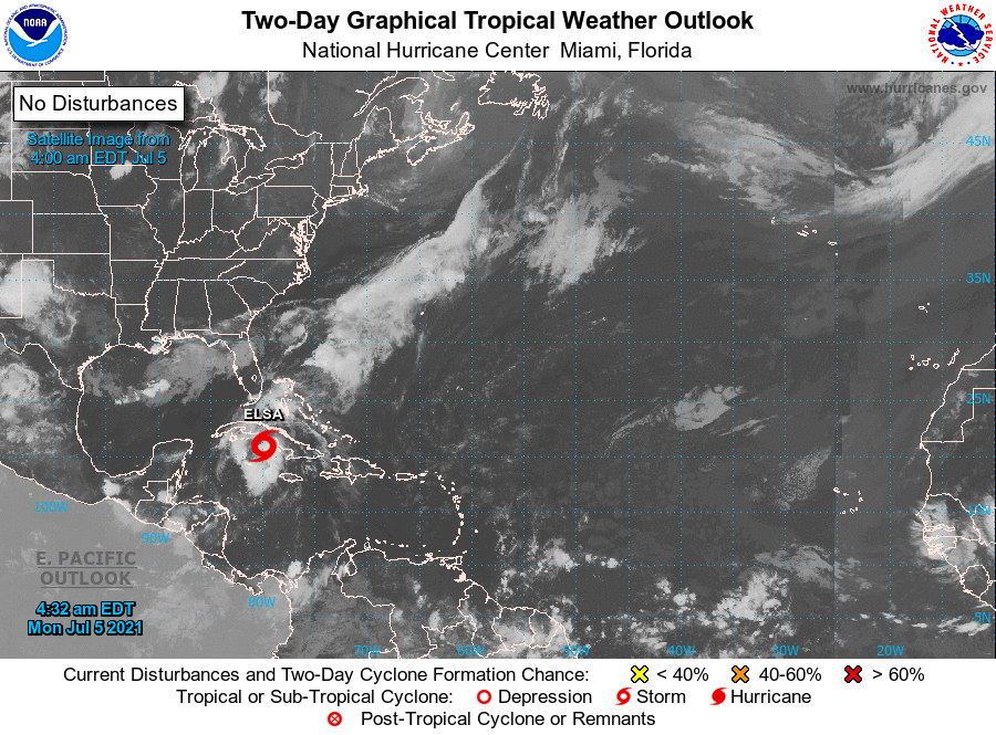
At 5 am TS Elsa was located at 21.0 N & 79.9 W and was moving NW @ 14 mph with peak winds of 65 mph and a barometric pressure of 1004 mbs (again note this is relatively very high). It is currently due south of Miami, FL. Elsa is currently south and west of where the NHC had projected it to be at this time yesterday. In light of this the models have shifted further west and Elsa is now projected to pass near the Dry Tortugas tomorrow and being at its closest approach to SE Florida tomorrow afternoon. On the current NHC track it would pass around 200 miles to the west of the Miami area.
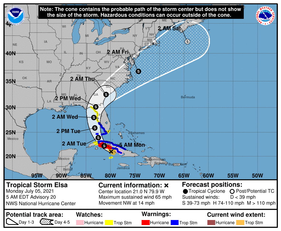
Elsa is currently a very compact storm with tropical storm force winds extending only 60 miles from the center. When it is west of South Florida the wind field is forecast to extend 90 miles. In light of this SE Florida will likely only see winds into the 20s with a few showers. Some rain but probably not a lot.
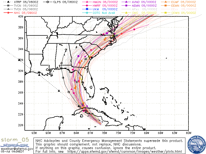
If you look at the Water Vapor Loop below you will notice a few features. First an upper level low just south of Louisiana, next a frontal boundary across southern Georgia, now drifting slightly north and TS Elsa south of Central Cuba slowly moving NW. My current track takes Elsa just north of the Isle of Pine crossing Western Cuba then tracking NW, then N, then NNE into the Big Bend area of Florida. Note the current model consensus takes it into the Panama City area. The official NHC track is east of that and I agree. Due to the upper level low in the northern Gulf of Mexico a slight deflection to the NE would be expected late in the forecast period. My current projection for landfall is between Homosassa Springs and Cedar Key centered around Waccasassa Bay Preserve State Park. The NHC track is a little west of that.
Fortunately this is not a strong system. Hopefully it will remain that way.
Until next time,
Matt.
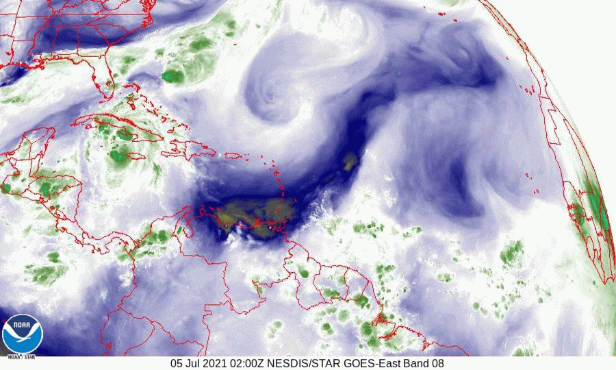
PS. If you look at the Saharan Air layer Analysis below you can see that there has been a significant invasion of dry Saharan air and dust into the Tropical Atlantic. There must have been some big dust storms. The Tropics will probably be quiet for at least the next week or two.
At 5 am TS Elsa was located at 21.0 N & 79.9 W and was moving NW @ 14 mph with peak winds of 65 mph and a barometric pressure of 1004 mbs (again note this is relatively very high). It is currently due south of Miami, FL. Elsa is currently south and west of where the NHC had projected it to be at this time yesterday. In light of this the models have shifted further west and Elsa is now projected to pass near the Dry Tortugas tomorrow and being at its closest approach to SE Florida tomorrow afternoon. On the current NHC track it would pass around 200 miles to the west of the Miami area.
Elsa is currently a very compact storm with tropical storm force winds extending only 60 miles from the center. When it is west of South Florida the wind field is forecast to extend 90 miles. In light of this SE Florida will likely only see winds into the 20s with a few showers. Some rain but probably not a lot.
If you look at the Water Vapor Loop below you will notice a few features. First an upper level low just south of Louisiana, next a frontal boundary across southern Georgia, now drifting slightly north and TS Elsa south of Central Cuba slowly moving NW. My current track takes Elsa just north of the Isle of Pine crossing Western Cuba then tracking NW, then N, then NNE into the Big Bend area of Florida. Note the current model consensus takes it into the Panama City area. The official NHC track is east of that and I agree. Due to the upper level low in the northern Gulf of Mexico a slight deflection to the NE would be expected late in the forecast period. My current projection for landfall is between Homosassa Springs and Cedar Key centered around Waccasassa Bay Preserve State Park. The NHC track is a little west of that.
Fortunately this is not a strong system. Hopefully it will remain that way.
Until next time,
Matt.
PS. If you look at the Saharan Air layer Analysis below you can see that there has been a significant invasion of dry Saharan air and dust into the Tropical Atlantic. There must have been some big dust storms. The Tropics will probably be quiet for at least the next week or two.