Good evening,
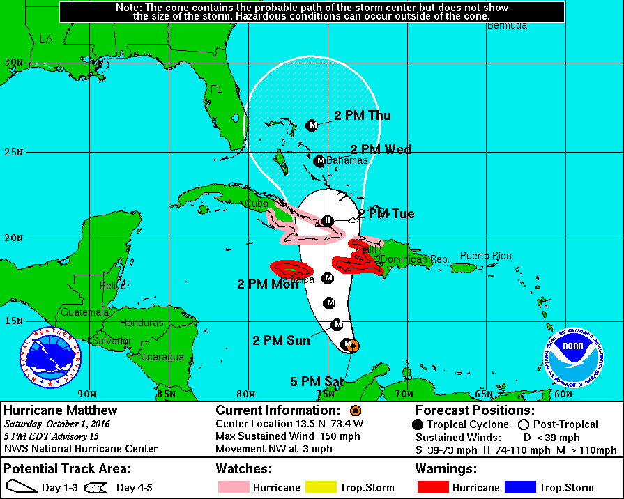
At 5:00 pm, major Hurricane Matthew was located at 13.5 N and 73.4 W, moving northwest at 3 mph with peak winds of 150 mph and a barometric pressure of 940 mb. During the day today, Matthew has been relatively stationary, meandering just off the north coast of Colombia. Its northwest move over the past three hours may just be a wobble or possibly the start of its turn northwest-north.
Matthew is a very compact storm. The eye spans only 5 nautical miles, and the eye wall just 6 nautical miles. Hurricane force winds span a total of 35 miles. Currently, if you are not within 20 miles of the eye, you would not be experiencing hurricane conditions.
Last night at 11 pm, Matthew was briefly a Cat 5 with 160 mph winds. Due to shear to its north, weakening is forecast as it moves north towards eastern Cuba. Shear is expected to decrease over the Bahamas, and reintensification may occur once it is in that region.
Overall, the forecast track of Matthew has changed little over the past four days. High pressure near Bermuda is expected to weaken and drift slowly to the east. This should allow Matthew to stay well east of South Florida.
By tomorrow, if this northwest move is real, we should have a better feel for its ultimate track, though presently things are looking positive for South Florida avoiding significant weather.
I'll write again tomorrow.
Until then, have a great weekend.
Matt
