Good morning.
Just a quick update on Idalia. Idalia was designated a hurricane at 5 am this morning, 12 hours later than originally forecast, this was due to it's further east than anticipated drift and land interactions with the western tip of Cuba. Hopefully this will translate to a slightly weaker storm at landfall however there are some concerning features to note this morning.
If you look at the water vapor loop from 5 am this morning you will notice a couple of things. First is Idalia spinning just north of Cuba, notice that the wide spread convection to its east is gone and it is consolidating around its center.
It appears to be about to undergo a period of rapid intensification. Idalia is a very small storm despite what the media is saying. At landfall tomorrow the NHC is currently forecasting hurricane force winds to only extend 20 miles to the east and 15 miles to the west of the center. The area affected by eye wall will be even smaller. I would anticipate an eye diameter of 10-20 miles at landfall, most likely 15 if it draws itself inward as I expect. Despite the media telling you not to focus on the center of the path, that is the opposite of what we should be doing. It would have to pass within 20 miles of you to experience a hurricane and likely within 12 to experience a major hurricane.
Due to the tighter storm the rain shield will be contracting as well. Miami-Dade will possibly receive no direct effects though we may see an enhancement of our normal afternoon showers later today.
Next if you look at the water vapor below focus on the frontal boundary from Louisiana to Tennessee. The eastern portion is further north than previously anticipated by the NWS. Where it is tomorrow will be key however because of this the NE turn may not occur until it has moved further north. The NHC has revised it's track slightly to the west however it is still east of the model consensus, see below. Forward speed is increasing and it is expected to be moving at 17-18 mph or more at landfall which should make it a shorter duration event.
I will be posting again around 5 pm and will try to pinpoint more precisely where it I believe it will make landfall.
Until then,
Matt.
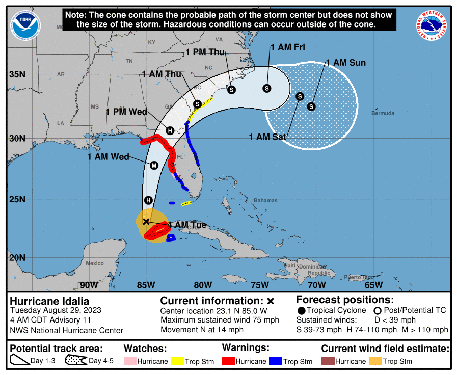
Just a quick update on Idalia. Idalia was designated a hurricane at 5 am this morning, 12 hours later than originally forecast, this was due to it's further east than anticipated drift and land interactions with the western tip of Cuba. Hopefully this will translate to a slightly weaker storm at landfall however there are some concerning features to note this morning.
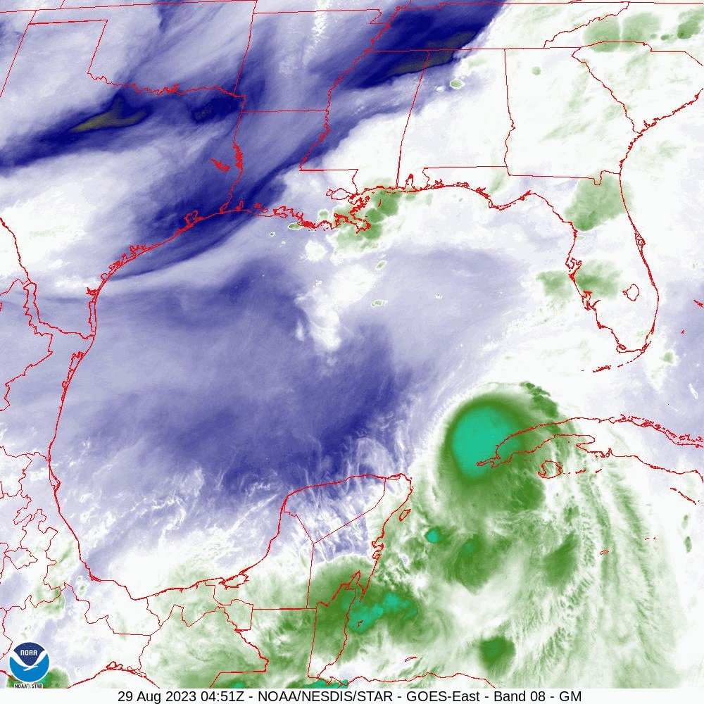
If you look at the water vapor loop from 5 am this morning you will notice a couple of things. First is Idalia spinning just north of Cuba, notice that the wide spread convection to its east is gone and it is consolidating around its center.
It appears to be about to undergo a period of rapid intensification. Idalia is a very small storm despite what the media is saying. At landfall tomorrow the NHC is currently forecasting hurricane force winds to only extend 20 miles to the east and 15 miles to the west of the center. The area affected by eye wall will be even smaller. I would anticipate an eye diameter of 10-20 miles at landfall, most likely 15 if it draws itself inward as I expect. Despite the media telling you not to focus on the center of the path, that is the opposite of what we should be doing. It would have to pass within 20 miles of you to experience a hurricane and likely within 12 to experience a major hurricane.
Due to the tighter storm the rain shield will be contracting as well. Miami-Dade will possibly receive no direct effects though we may see an enhancement of our normal afternoon showers later today.
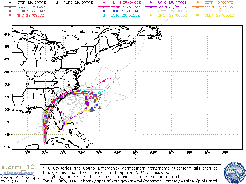
Next if you look at the water vapor below focus on the frontal boundary from Louisiana to Tennessee. The eastern portion is further north than previously anticipated by the NWS. Where it is tomorrow will be key however because of this the NE turn may not occur until it has moved further north. The NHC has revised it's track slightly to the west however it is still east of the model consensus, see below. Forward speed is increasing and it is expected to be moving at 17-18 mph or more at landfall which should make it a shorter duration event.
I will be posting again around 5 pm and will try to pinpoint more precisely where it I believe it will make landfall.
Until then,
Matt.