Good morning.
There are a few interesting changes of note in the tropics this am.
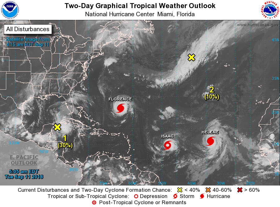
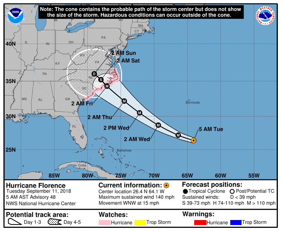
First with regard to Florence it is moving faster though not as fast as the NHC had predicted and it is moving further north than they had projected. It is currently approximately 40 miles north and east of where they had expected it to be at this time, per yesterdays forecast. As a result of this and other data the models have shifted north and have slowed some. They also found the high pressure over the Mid-West to be stronger than they had anticipated. In addition a new disturbance over the NW Caribbean is forecast to move into the western Gulf of Mexico, (See top 2 diagrams) . If that occurs it would tend to strengthen and nudge NE the Mid West high. If Florence slows enough it may be just enough to keep it off shore. If you look at the models below the Global models still bring it on shore however 30-40% of the GFS models remain offshore. This trend is up significantly from yesterday. Trends are important. In general the Globals do a better job in dealing with upper level lows than the GFS, however when we are just dealing with high pressure systems GFS tends to out perform. There is currently only one tiny upper level low between the Carolinas and Florence. This should have a negligible affect on it therefore I would favor the GFS solutions for this storm. It does not mean that it will miss, but the possibility may be increasing. We'll have to see.
The Outer Banks still appear to be at greatest risk. It is expected to slow down before landfall as the high pressure to its west moves eastward. It may reach Cat 5 status today however due to shear and slowing it is expected to be a Cat 4 as it approaches the coast.
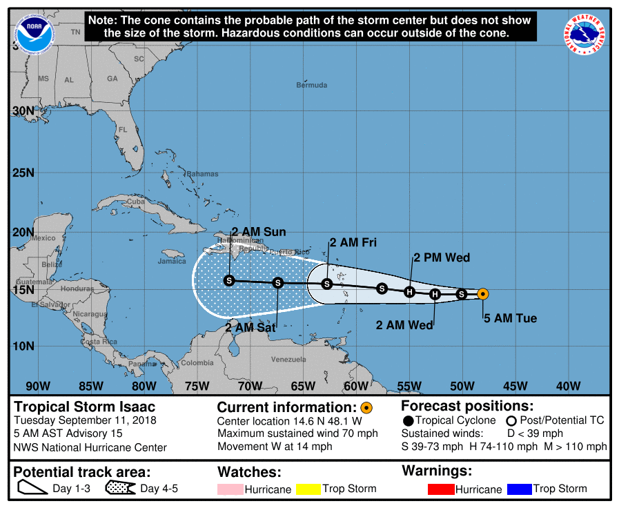
With regard to Isaac, due to shear it has weakened some and there has been an increase in spread of the models with several turning it north into the open Atlantic. (See "Models Isaac" below.) The NHC's track has not changed. We're just going to have to wait on that.
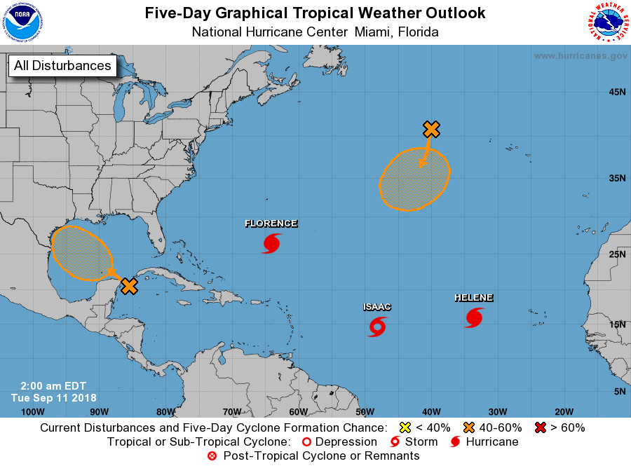
In the bottom diagram you can see that the Western Gulf of Mexico remains very warm. The system over the NW Caribbean may use that to strengthen, fortunately it should not have much time to develop significantly but we'll see.
I have my fingers crossed for the Carolinas.
Until next time, Matt.
There are a few interesting changes of note in the tropics this am.
First with regard to Florence it is moving faster though not as fast as the NHC had predicted and it is moving further north than they had projected. It is currently approximately 40 miles north and east of where they had expected it to be at this time, per yesterdays forecast. As a result of this and other data the models have shifted north and have slowed some. They also found the high pressure over the Mid-West to be stronger than they had anticipated. In addition a new disturbance over the NW Caribbean is forecast to move into the western Gulf of Mexico, (See top 2 diagrams) . If that occurs it would tend to strengthen and nudge NE the Mid West high. If Florence slows enough it may be just enough to keep it off shore. If you look at the models below the Global models still bring it on shore however 30-40% of the GFS models remain offshore. This trend is up significantly from yesterday. Trends are important. In general the Globals do a better job in dealing with upper level lows than the GFS, however when we are just dealing with high pressure systems GFS tends to out perform. There is currently only one tiny upper level low between the Carolinas and Florence. This should have a negligible affect on it therefore I would favor the GFS solutions for this storm. It does not mean that it will miss, but the possibility may be increasing. We'll have to see.
The Outer Banks still appear to be at greatest risk. It is expected to slow down before landfall as the high pressure to its west moves eastward. It may reach Cat 5 status today however due to shear and slowing it is expected to be a Cat 4 as it approaches the coast.
With regard to Isaac, due to shear it has weakened some and there has been an increase in spread of the models with several turning it north into the open Atlantic. (See "Models Isaac" below.) The NHC's track has not changed. We're just going to have to wait on that.
In the bottom diagram you can see that the Western Gulf of Mexico remains very warm. The system over the NW Caribbean may use that to strengthen, fortunately it should not have much time to develop significantly but we'll see.
I have my fingers crossed for the Carolinas.
Until next time, Matt.
  |   |

