Good evening.
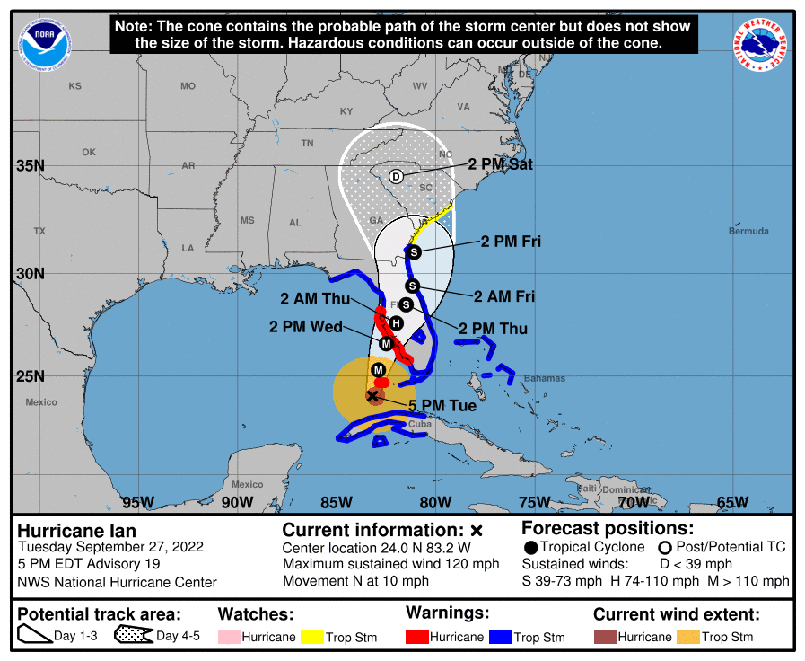
Hurricane Ian is currently located in the SE Gulf of Mexico and has been moving steadily NNE at 10 mph throughout the day today. It is currently east of where the NHC had forecast to be at this time yesterday, and is moving faster. As a result the NHC's track has shifted to the south and east and the NHC is currently forecasting it to make landfall tomorrow evening between Ft. Myers and Tampa. It is currently headed towards Venice, Florida. As we've seen its track has been fluctuating and it may continue to do so, however, it is running out of time.
On this track Tampa would still get a hurricane however it would be spared the worst of it and its surge.
Its eye is currently 20 miles wide and at present appears to be undergoing an eye wall replacement cycle with shrinkage of its eye. This is often a sign of intensification and the NHC is currently forecasting it to be a 130 mph Cat 4 hurricane at landfall tomorrow due to its more southerly route. Hopefully it will weaken some prior to landfall.
Due to its more SE location Miami-Dade and Broward Counties may get winds into the 30s late tonight and early tomorrow morning in squalls. It should be due west of Miami at around 4 am tomorrow.
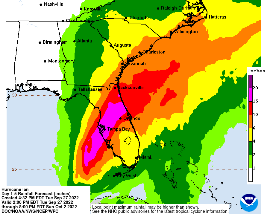
I've attached a revised Rainfall Forecast accounting for the more southerly track.
I'll write again early tomorrow morning.
Until then,
Matt.
Hurricane Ian is currently located in the SE Gulf of Mexico and has been moving steadily NNE at 10 mph throughout the day today. It is currently east of where the NHC had forecast to be at this time yesterday, and is moving faster. As a result the NHC's track has shifted to the south and east and the NHC is currently forecasting it to make landfall tomorrow evening between Ft. Myers and Tampa. It is currently headed towards Venice, Florida. As we've seen its track has been fluctuating and it may continue to do so, however, it is running out of time.
On this track Tampa would still get a hurricane however it would be spared the worst of it and its surge.
Its eye is currently 20 miles wide and at present appears to be undergoing an eye wall replacement cycle with shrinkage of its eye. This is often a sign of intensification and the NHC is currently forecasting it to be a 130 mph Cat 4 hurricane at landfall tomorrow due to its more southerly route. Hopefully it will weaken some prior to landfall.
Due to its more SE location Miami-Dade and Broward Counties may get winds into the 30s late tonight and early tomorrow morning in squalls. It should be due west of Miami at around 4 am tomorrow.
I've attached a revised Rainfall Forecast accounting for the more southerly track.
I'll write again early tomorrow morning.
Until then,
Matt.