Good morning.
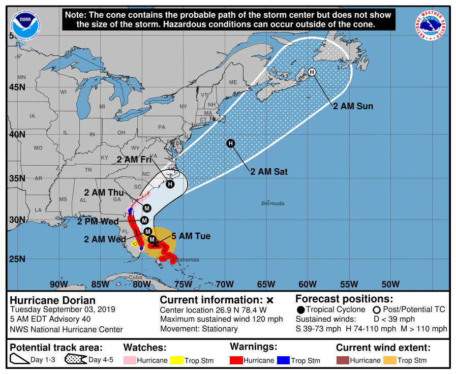
At 5 am Dorian was located just north of Grand Bahama at 26.9° north 78.4° west and was stationary. The barometric pressure was 950 mbs and peak sustained winds were 120 mph. Of note is that Dorians coordinates are exactly the same as they were at 6 PM. During that time Dorian has been wobbling slightly in the same area with the southern eye wall moving on and off of Grand Bahama. The devastation after it pulls away will be extensive. I suspect that there will be near complete loss of all vegetation as well as extensive damage to many structures. Also of note is that Dorian is weakening. This is due to land interactions, the shallow waters north of Grand Bahama Island as well a possibly a component from a phenomenon known as upwelling. The northern portion of the eye is over deep water. When Dorian was a CAT 5 with winds of 185 mph it created a storm surge or wall of water moving in all directions approximately 20 feet high, with the winds of 120 mph the storm surge is probably in the range of 10 to 12 feet. This wall of water moving in all directions needs to be replaced. This occurs from the depths. Normally storm draw from the top 200 feet of the water column however when they are stationary over long periods of time water is drawn from much deeper. This very deep water is often much cooler than 80°. Especially in northern latitudes the phenomenon can be dramatic.
Dorian remains well east of the yesterday’s NHC’s projected track at this point in time and my track has not changed since yesterday evening. Note the NHC has now moved its track in line with mine. However until it begins it’s north west and north move later today we won’t know for sure as furthers wobbles or drifts to the west could occur. I’ll be writing again later this evening, sooner if significant changes occur.
Until next time,
Matt.