Good morning.
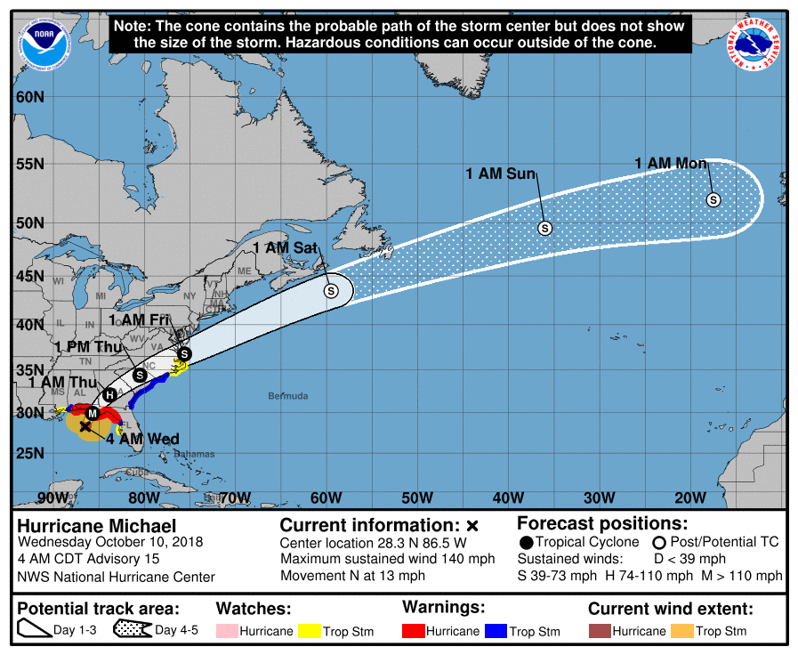
At 7 am H. Michael had peak winds of 140 mph and a minimum pressure of 937 mbs. Overnight Michael has steadily strengthened. The NHC is currently forecasting it to be a 145 mph Cat 4 hurricane at land fall. The Panama City area continues to be in the center of its path.
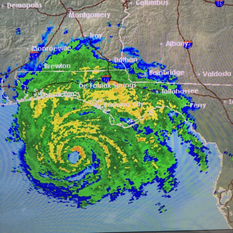
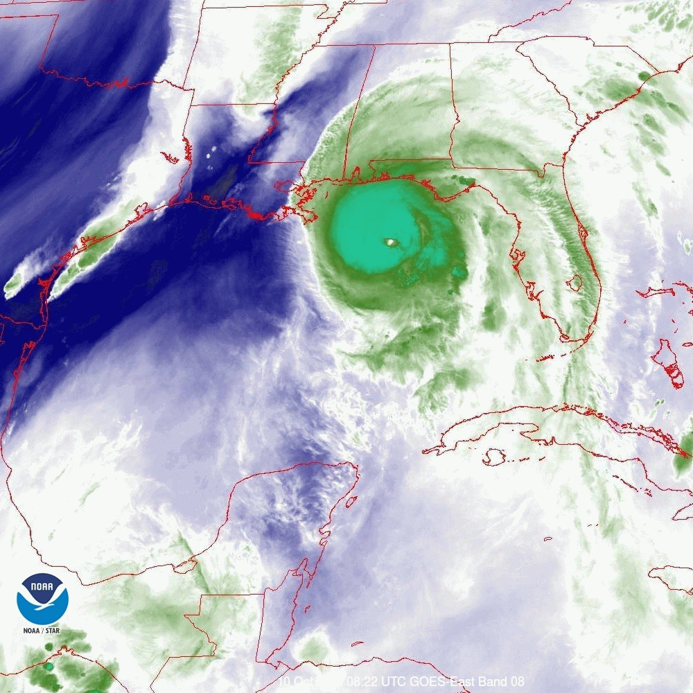
Below you can see 1) the forecast track 2) the current satellite loop of the Gulf of Mexico 3) current Tallahassee radar and 4) the current water vapor loop of the Gulf of Mexico.
If you look at the satellite loop you can see Michael's distinct eye wobbling to the NNE. On radar you can see the eye wall. (See weather Trivia section for discussion about "The Eye Wall".) On the Water Vapor Loop notice how the frontal system to the west has now moved into Louisiana, this is why it is starting to move more to the NE; compare this to where it was yesterday. Hurricane force winds currently extend 40 miles to the NE and 30 miles to the NW of the center. The eye is currently 20 miles wide. The eye wall is where the strongest winds in a hurricane occur. Eye walls are generally 5-7 miles wide, therefore a 35-40 mile wide area will likely experience Cat 4 conditions. (Note this is wider than the expected 30-34 mile wide area to account for the effects of wobble.) Major hurricane conditions are generally not found outside of the eye wall. In other words if you are over 20 miles from the center of its path you should miss the worst of it.
Tallahassee will likely receive hurricane conditions today. This will be a devastating event for the Panhandle and Big Bend areas of Florida today. Large trees and frame structures will enhance the damage. Storm surge could be significant.
My best to everyone,
Matt.
PS. I'm sorry for the rushed report this am. I had written a nicer post at 7 this am however just prior to publishing it, it disappeared and I had to rush to put out a report with little time.
At 7 am H. Michael had peak winds of 140 mph and a minimum pressure of 937 mbs. Overnight Michael has steadily strengthened. The NHC is currently forecasting it to be a 145 mph Cat 4 hurricane at land fall. The Panama City area continues to be in the center of its path.
Below you can see 1) the forecast track 2) the current satellite loop of the Gulf of Mexico 3) current Tallahassee radar and 4) the current water vapor loop of the Gulf of Mexico.
If you look at the satellite loop you can see Michael's distinct eye wobbling to the NNE. On radar you can see the eye wall. (See weather Trivia section for discussion about "The Eye Wall".) On the Water Vapor Loop notice how the frontal system to the west has now moved into Louisiana, this is why it is starting to move more to the NE; compare this to where it was yesterday. Hurricane force winds currently extend 40 miles to the NE and 30 miles to the NW of the center. The eye is currently 20 miles wide. The eye wall is where the strongest winds in a hurricane occur. Eye walls are generally 5-7 miles wide, therefore a 35-40 mile wide area will likely experience Cat 4 conditions. (Note this is wider than the expected 30-34 mile wide area to account for the effects of wobble.) Major hurricane conditions are generally not found outside of the eye wall. In other words if you are over 20 miles from the center of its path you should miss the worst of it.
Tallahassee will likely receive hurricane conditions today. This will be a devastating event for the Panhandle and Big Bend areas of Florida today. Large trees and frame structures will enhance the damage. Storm surge could be significant.
My best to everyone,
Matt.
PS. I'm sorry for the rushed report this am. I had written a nicer post at 7 this am however just prior to publishing it, it disappeared and I had to rush to put out a report with little time.