Good morning.
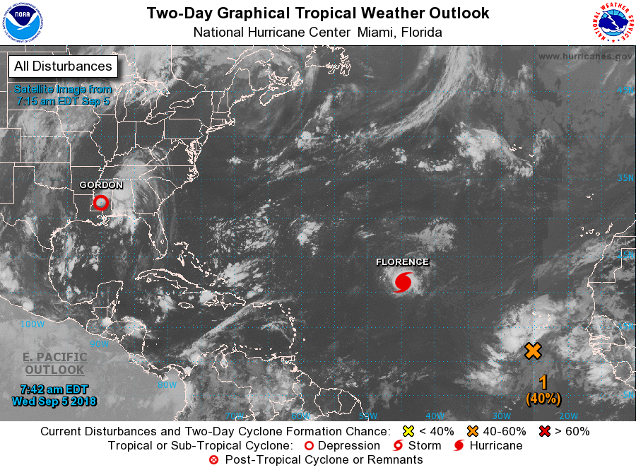
Tropical Storm Gordon made landfall last night just west of the Alabama- Mississippi border as a strong tropical storm. A NOAA Coastal Marine Observing site on Dauphin Island, Alabama measured a sustained wind of 57 mph (91 kph) with a gust to 72 mph (117 kph) which have been the highest winds reported so far. The lowest minimum central pressure as estimated from NOAA Hurricane Hunter aircraft data was 997 MB (29.44 inches). Fortunately prior to landfall due to shear it lost its southern eye wall and it never made it to hurricane intensity.
I recorded 5.56" of rain at my house from Gordon, but fortunately we had no wind damage.
Elsewhere there are a few features of note.
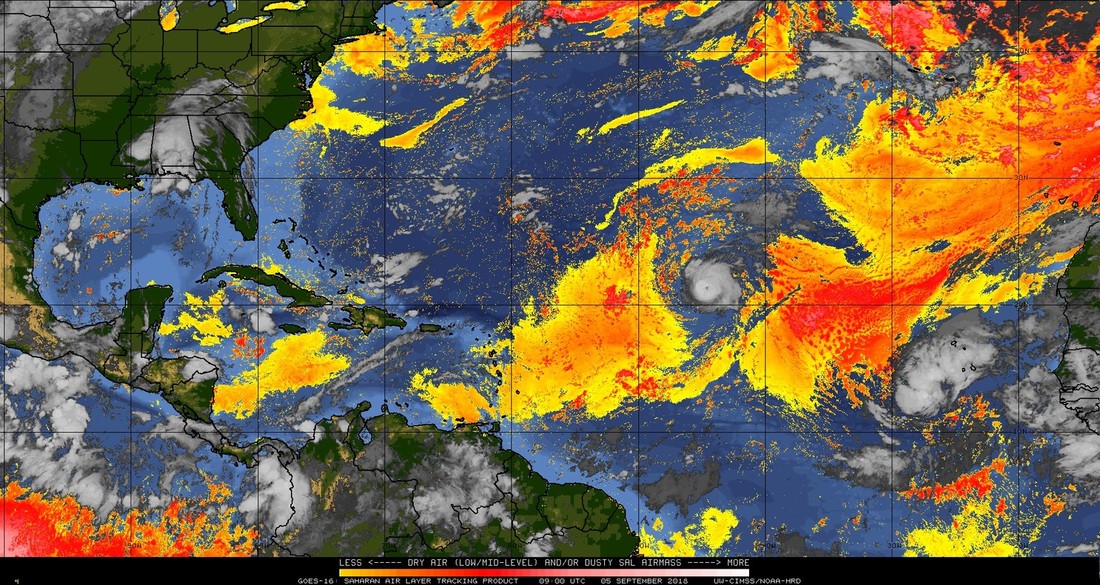
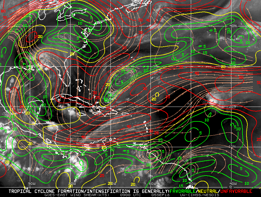
First is Hurricane Florence in the Central Atlantic which is moving NW with 105 mph winds, it is entering an area of high shear and should start to weaken soon. (See Wind Shear Analysis, bottom diagram). Notice its well defined eye in the Saharan Air layer Analysis and the Wind Shear Analysis below. FYI that does not usually occur until hurricane force winds reach > or = 100 mph. It is entering the mid Atlantic trough as discussed previously and should miss the US.
Second is the orange X in the first diagram. This should track just south and west of Florence's track, being drawn towards the low pressure trough left in Florence's wake. It should also be drawn into
the mid-Atlantic Trough, and hopefully miss the US as well.
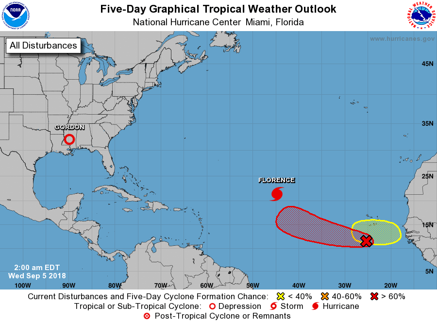
Third is the yellow circle in the second diagram. This disturbance is still over Africa and is the area I wrote about in my 9/3/18, 5:30 am forecast and will be the one to watch. Fortunately its a long ways out and there is still abundant Saharan Dust and high shear areas between it and us.
It has a lot of obstacles in its way, I'll be keeping an eye on it.
Until next time, Matt.
Tropical Storm Gordon made landfall last night just west of the Alabama- Mississippi border as a strong tropical storm. A NOAA Coastal Marine Observing site on Dauphin Island, Alabama measured a sustained wind of 57 mph (91 kph) with a gust to 72 mph (117 kph) which have been the highest winds reported so far. The lowest minimum central pressure as estimated from NOAA Hurricane Hunter aircraft data was 997 MB (29.44 inches). Fortunately prior to landfall due to shear it lost its southern eye wall and it never made it to hurricane intensity.
I recorded 5.56" of rain at my house from Gordon, but fortunately we had no wind damage.
Elsewhere there are a few features of note.
First is Hurricane Florence in the Central Atlantic which is moving NW with 105 mph winds, it is entering an area of high shear and should start to weaken soon. (See Wind Shear Analysis, bottom diagram). Notice its well defined eye in the Saharan Air layer Analysis and the Wind Shear Analysis below. FYI that does not usually occur until hurricane force winds reach > or = 100 mph. It is entering the mid Atlantic trough as discussed previously and should miss the US.
Second is the orange X in the first diagram. This should track just south and west of Florence's track, being drawn towards the low pressure trough left in Florence's wake. It should also be drawn into
the mid-Atlantic Trough, and hopefully miss the US as well.
Third is the yellow circle in the second diagram. This disturbance is still over Africa and is the area I wrote about in my 9/3/18, 5:30 am forecast and will be the one to watch. Fortunately its a long ways out and there is still abundant Saharan Dust and high shear areas between it and us.
It has a lot of obstacles in its way, I'll be keeping an eye on it.
Until next time, Matt.