Good morning.
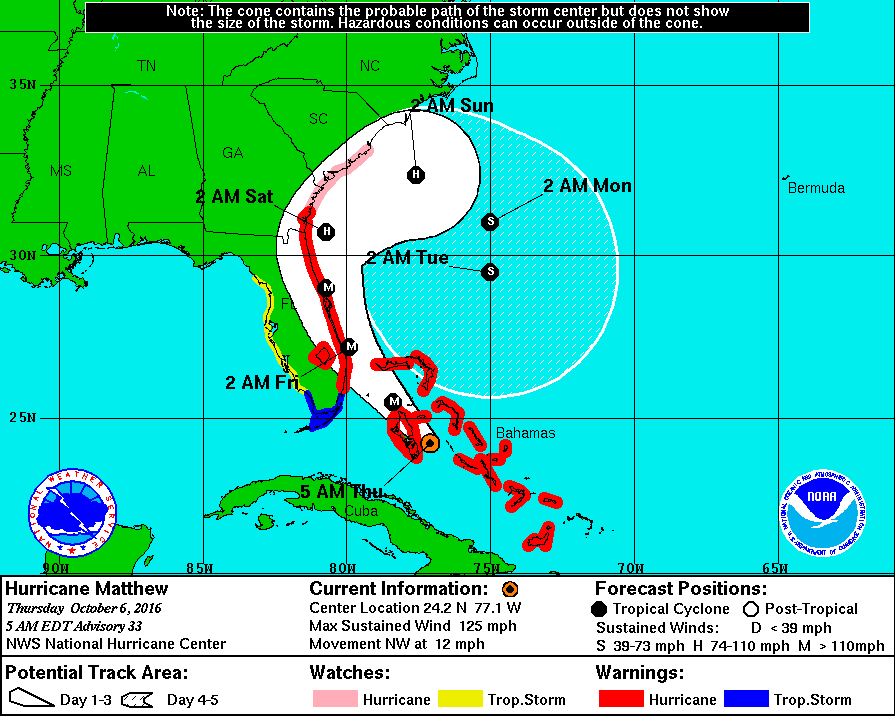
At 5 AM Hurricane Matthew was located @ 24.2 N & 77.1 W with a barometric pressure of 944 mbs and peak winds of 125 mph, moving NW at 12 mph. It is currently approaching Nassau as a Cat 3 Hurricane. Over night pressures have been dropping and it is expected to be a Cat 4 as it approaches the Palm Beach area tonight. The models are currently in good agreement with the forecast track below. Miami-Dade should still miss the heart of the storm and winds of 25-34 mph with gusts to 40-50 mph are forecast. Broward should see more as noted last night. It is still a compact storm with most of the weather on the eastern side of the storm. See forecast advisory below.
FORECAST VALID 06/1800Z 25.5N 78.4W MAX WIND 120 KT...GUSTS 145 KT.
64 KT... 35NE 30SE 25SW 30NW.
50 KT... 70NE 70SE 40SW 50NW.
34 KT...150NE 140SE 80SW 90NW.
Hurricane force winds only extend 30 miles to the west of the center, storm force winds, up to 90 miles. After it gets north of Miami it will start to cross the Gulf Stream and it should strengthen and the wind fields should expand.
If it follows the present track this would be a very severe storm from Palm Beach to Daytona with a significant storm surge. People in that area should leave coastal areas.
I wish we had better news for Palm Beach north, I'll hope for a track slightly to the east a slight shift would make a huge difference. I have my fingers crossed.
Until later, Matt.
