Matt on the Tropics
Tropical Updates
  • Home
  • About
  • Archive (pre-blog)
  • Contact
  • Weather Links
  • Weather Trivia

Tropical update sunday 9-10-17, 4 am

9/10/2017

 
Good morning.

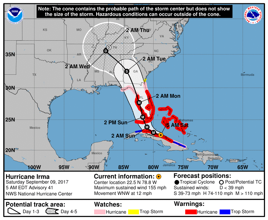
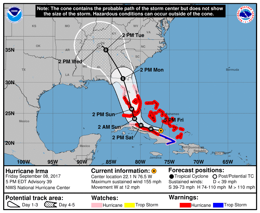
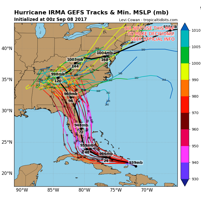
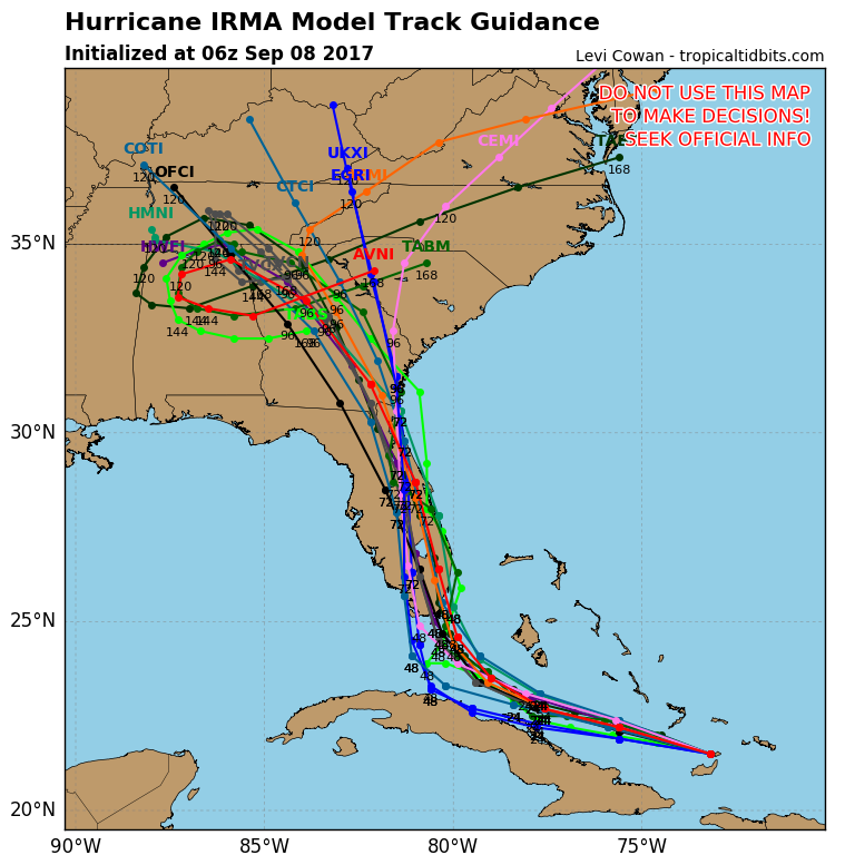
At 4 am H. Irma was located at 23.9 and 81.4 W and was moving NW 6 mph with peak winds of 130 mph. Irma has begun its NW move and appears to be headed toward the Lower Keys. The NHC track has changed little. The main difference will be a slight shift to the west with the Lower Keys rather than the Middle Keys getting the worst of it. Landfall between Ft Myers and Tampa is still expected but it will be close. A lot of the West Coast of Florida will be experiencing significant hurricane conditions. Winds will be increasing soon across Miami-Dade County. It is currently about 80 miles to our west and 120 miles to our south. It should be due west of Miami around 6-8 pm, that will be its closest approach. Winds will be out of the S at that time. Winds will then shift to the SW and then W, and then NW. When they shift to NW conditions will be improving, which should be early tomorrow am.  Irma has been moving very slowly over night however it appears to be starting to pick up speed.

I'll be writing frequently if I can.

Best to all,                                            Matt.

​

Tropical update Saturday 9-9-17, 8 pm

9/9/2017

 
​Good evening.

At 8 pm Hurricane Irma was located at 23.3 N & 80.8. W with peak winds of 120 mph and was  moving WNW @ 7 mph along the northern coast of Cuba. Irma is slowing down, this is an indication that its NW turn should begin soon. Irma's track remains unchanged since this am.
Rainfall today so far has totaled 1.21", but as stated earlier, the real weather will start tomorrow.

I will write next tomorrow am. Note I have lost internet and I will be sending reports  through a friend in North Carolina, if I have phone service.

Until tomorrow,                           Matt.

September 9th, 2017

9/9/2017


Tropical Update Saturday 9-9-17, 2 pm

9/9/2017

 
Good afternoon.

At 2 pm Hurricane Irma was located at 23.1 N and 80.2 W and was moving just north of W @ 9 mph with peak winds of 125 mph. Irma continues to move along the north coast of Central Cuba. The NHC's and my track have not changed since this AMs update. Irma will be due south of Miami at around 3 pm today and the anticipated wind forecast as noted this am has not changed. We'll have a few squalls today however the main weather which we'll receive will be tomorrow starting early am.

​I'll write again later.

Until then,                                                        Matt.

Saturday 9-9-17, 11 am

9/9/2017

 
11:00 AM EDT Sat Sep 9
Location: 22.8°N 79.8°W
Moving: W at 9 mph
Min pressure: 941 mb
Max sustained: 125 mph

Over the past 3 hours Irma has been going west and has slowed. The slowing has been anticipated as a prelude to its NW-N turn. In light of this it probably will not go much further west than the track of this am.  Pressures are rising and winds have decreased to Cat 3 status, and they should continue to decrease.

We'll continue to watch. No change in its track for now.

                                                                  Matt.


tropical update Saturday 9-9-17, 10:30 am

9/9/2017

 
Good morning.

Irma is currently making landfall along the northern coast of Central Cuba. As noted in this AMs forecast Irma is weakening.  It is probably a Cat 3 at present however it should regain some strength after it gets into the Florida Straits early tomorrow am.. Its westerly track is persisting and it is possible that we may see a track slightly further to the west. We'll just have to see.
In about 3 hours it should be due south of Miami.

Below is a link to Key West Radar where you will be able to see live what it is doing and where the rain bands are. The green donut on the bottom is the core of the hurricane, that is where the strongest winds are. If that donut doesn't hit you, you will be spared its worst part. As long as Key West radar is up you will be able to track its progress. If it goes down switch to Miami radar.

https://radar.weather.gov/radar.php?product=N0Z&rid=BYX&loop=yes

I'll write again later however its landfall with Cuba could go a long way in reducing its impact here.

Until next time,                                  Matt.

https://radar.weather.gov/radar.php?product=N0Z&rid=amx&loop=yes
https://radar.weather.gov/radar.php?product=N0Z&rid=BYX&loop=yes
Picture

tropical update Saturday 9-9-17, 6 am

9/9/2017

 
Picture
Good morning.

At 5am Irma was located at 22.5 N & 78.8 W and was moving WNW @ 12 mph. Irma is currently brushing the north coast of Central Cuba and should do so most of today. In looking at the water vapor loop (second diagram below) you can see that Irma is weakening. This is due to land interaction and disruption of its circulation by the mountains of Cuba. The NHC is forecasting it to be a 150 mph storm as it approaches the west coast of Florida tomorrow. I suspect it will be weaker, however they need everyone to be prepared for the worst. Increasing shear to its north should prevent significant strengthening as it moves northward, however intensity forecasts are very hard to make. Irma continues to move south of their prior track which should allow it to move a little further west and the current track reflects it with a shift towards Fort Myers-Tampa. Prior to its NW-N turn  it is expected to slow down. This may prolong our weather event.
Irma is a very large storm. The eye is 30 miles across currently. When it approaches Florida the wind field on the east side of the storm due to shear will be very large.

The forecast winds are as follows***very Important**

The eye wall will span 30 miles from the center (the Cat 4 winds)
Hurricane force winds 70 miles
Strong Tropical storm force winds 120 miles
Tropical Storm force winds 220 miles

The first outer bands are coming into South Florida now, then there should be a lull followed by winds steadily increasing starting early afternoon, mid-late morning in the Keys.
On the current track it is forecast to pass approximately 100 miles west of Miami. IF that occurs peak winds would be in the 60s in Miami with gusts into the 70s. With the size of the wind field they could last over 36 hours, From this afternoon until Monday am. For your given location everyone can calculate what winds you can expect. Pay attention to the coordinates of the storm. You can find the coordinates of your location by going to http://forecast.weather.gov/MapClick.php?lon=-80.32930450451518&lat=25.615100138543553#.WbPL-P1K2Uk

Go to the topographic map and pan in and out to find you general location then click on it. A green box will appear and the coordinates of your location will be under the diagram. Each degree of longitude and latitude in our area is approximately 70 miles (about 69). If the track brings it 1.1 degrees from you it will be 77 miles away etc.

Winds should start out of the SE, then S, then SW, then W then NW. The strongest will be the SE, S and SW. At home keep all interior doors closed. Stay away from windows even if they are shuttered. Carry a towel with you to protect yourself from debris or glass in the event of a breach. Don't open exterior doors or doors to your garage during the storm. Wear pants. If your in an area of Hurricane force winds find an interior room, generally the smaller the better. Remove things from walls or shelves in that room in the event of a breach. If a breach occurs lay on the floor. Cover yourself with what ever is available. Stay safe. On the current track Miami Dade, except for extreme western portions should see primarily a tree storm. There will be lots of trees and branches down. Watch out for power lines. Power is likely to go out. With the storm passing to the west of us expect lots of rain. 10-20" are currently forecast. Watch out for flooding.

Elsewhere Jose is expected to stall in a few days so we won't be able to fully write it off yet, see below, we'll have to re-evaluate him later.

I'll write later but it is appearing more likely that Miami will avoid the worse of the storm. The Middle Keys and the West Coast of Florida will see much more.

My best to all,                                          Matt.


Picture
Picture
Picture

tropical update Friday 9-8-17, 5 pm

9/8/2017

 
Picture
Good evening.

At 5 pm Irma was located at 22.1 N and 76.5 W and was moving W @ 12 mph. Irma has been moving steadily west today. Over the past few hours it has made a slight northern move however it only appears to be a wobble.
The NHC track has shifted westward and it is now similar to my track as noted this am. The models are coming into good agreement on this however until it is actually happens further model shifting is possible. On the present NHC track it would pass approximately 80 miles to the west of Miami. Even if it did we would still experience significant weather with heavy rain with squalls and almost 24 hours of tropical storm force winds.

Once things become clearer I'll write more specifically what we all can expect, including for different  locations.

Have a good night and finish your preparations.

Until tomorrow am,                                 Matt.
Picture

tropical update Friday 9-8-17, 10:20 am

9/8/2017

 
Good morning.

There has been no change in Irma's trajectory so far this am and it is still headed toward the northern coast of Central Cuba. This AMs forecast still holds. I'll write again around 5 pm.

                                                                 Matt.
Picture

tropical update Friday 9-8-17, 7 am

9/8/2017

 
Picture
Good morning.

At 5 am Hurricane Irma was located at 21.7 N & 73.8 W and was moving just north of W @ 16 mph. Since last night Irma has taken a definite more westerly move. More so than the NHC track currently reflects. If you look at the surface map below Irma is moving along the periphery of high pressure to its north. With the more southerly and westerly track Irma may come close to or cross into the northern Coast of Central Cuba. If this were to occur it would weaken it some. In addition it would probably lead to a somewhat more westerly course. So far of all the models the European Model (the dark blue line in the lowest diagram which moves along the coast of Cuba) is the one which best reflects the current motion and in addition has been doing the best job in forecasting Irma's track to date.
The NHC track continues to show a worst case scenario.
Based on its current motion my current track takes Irma through the Florida Keys into the Naples area, then northward into the state. After landfall it should weaken due to land interactions and increasing shear to its north. Its eye is currently 20 miles wide and the outer eye wall spans 50 miles. In other words it would need to pass within 30 miles of you (in its current condition) to experience major hurricane conditions. We're just going to have to see. It's still early.

I'll be writing frequently going forward and once thing become clearer will let you know what to expect.

                                                           Matt

Picture
Picture
Picture
Picture
<<Previous
Forward>>

    Categories

    All
    Preseason Update