Matt on the Tropics
Tropical Updates
  • Home
  • About
  • Archive (pre-blog)
  • Contact
  • Weather Links
  • Weather Trivia

Tropical Update Friday 7/21/23, 5 pm

7/21/2023

 
Good evening.

After a couple of challenging weeks I finally have my site back up. 

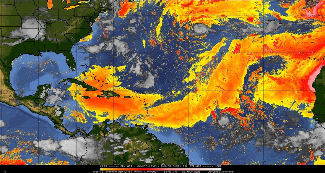
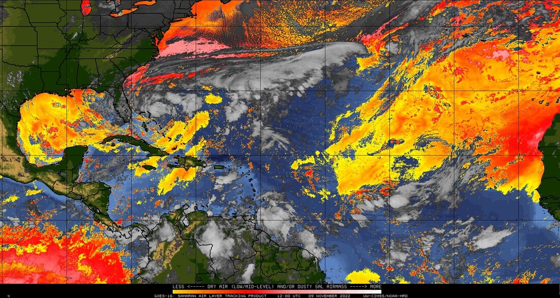
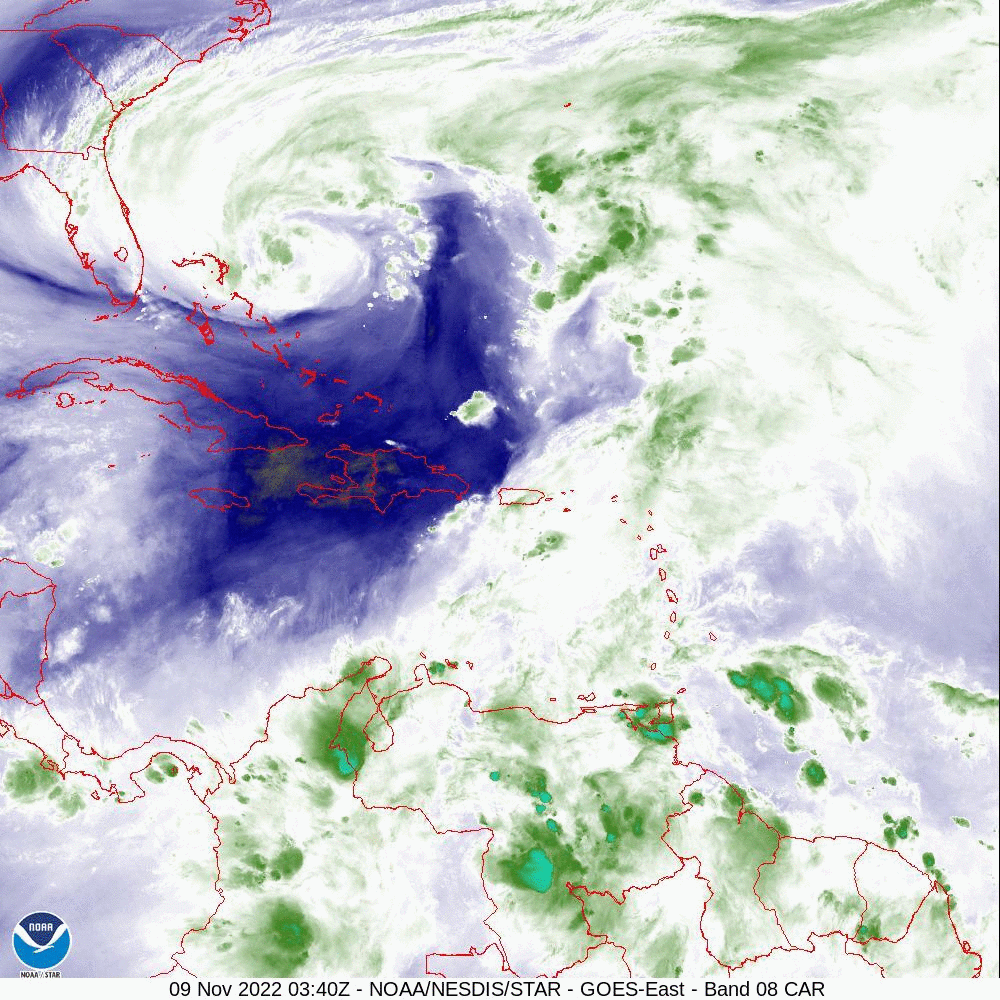
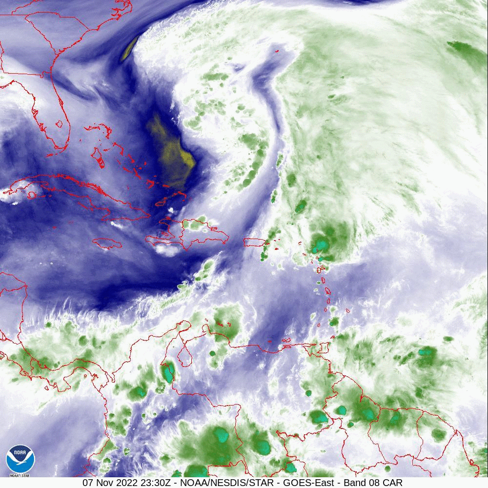
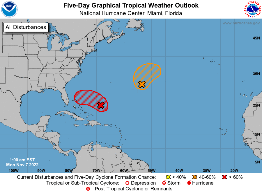
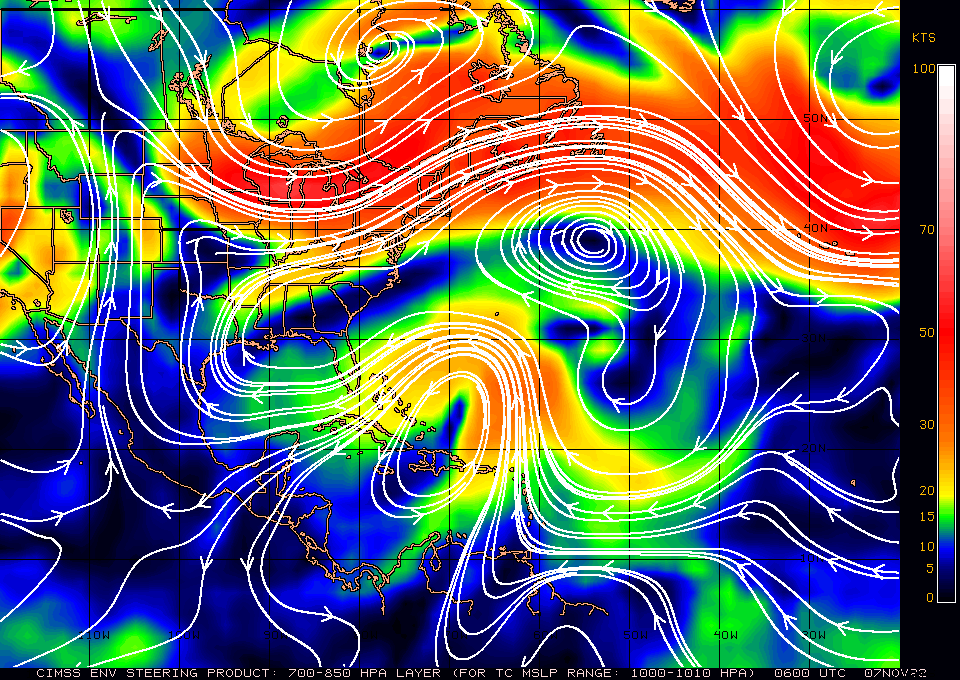
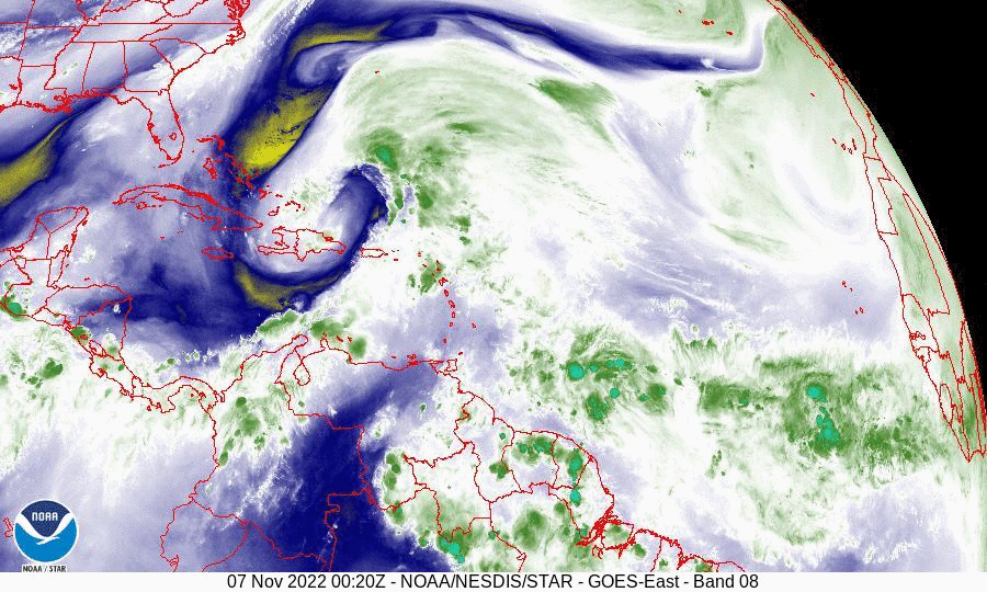
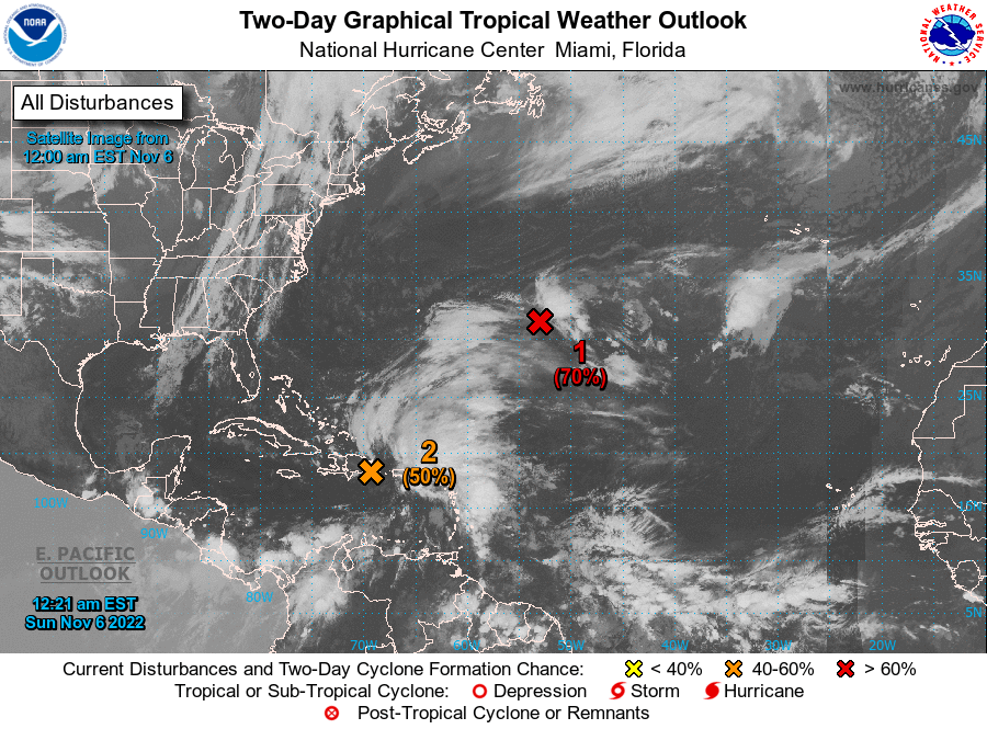
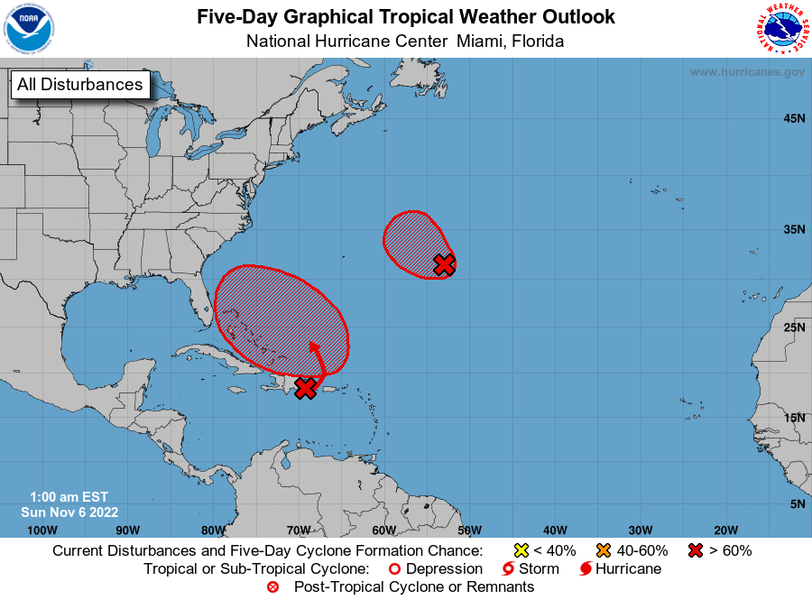
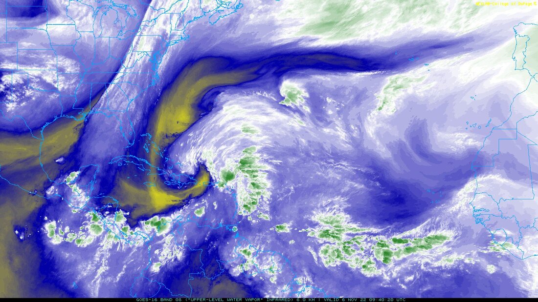
I am currently writing about a system in the South Central Tropical Atlantic which the NHC has designated AL 95. The NHC is giving a 60% chance of tropical development over the next 5 days and expects it to enter the Caribbean. Conditions there are not ideal with abundant dry air currently, see SAL diagram. I'll be watching it but am not overly concerned at present.

Matt.

PS. We have been experiencing unprecedented, scary hot temperatures in South Florida as well as other parts of the US the past 2-3 weeks. In fact last Thursday morning at 06:30 it was 87 degrees, something I've never seen before, 82 had been the highest. I believe this is largely due to the extensive fires in Canada (over 25 million acres) with a prolonged NW flow which is pumping a huge amount of particulate matter and CO2 into the atmosphere enhancing the greenhouse effect. Hopefully the effects will be temporary. A rain event is needed up there to stop the fires.
​
Picture
Picture

July 11th, 2023

7/11/2023


Tropical Update Friday 6-23-23, 8 pm

6/23/2023

 
I'm back !!!

I had written a great post 3 d ago stating that TD # 2, which became Bret, despite the NHC's initial track, was not going to affect South Florida, however my website went down and I've been in repeated contact with IT at BlueHost the past 3 days trying to get it back up. Fortunately they just fixed the problem.

Currently Bret and Cindy are out there and neither should pose a threat to Florida or the US. Bret is going to pass just north of Lake Maracaibo, Venezuela tomorrow and should enhance the Catatumbo Lightning Phenomenon, (the worlds largest ozone generator).

Elsewhere all is quiet. High pressure over and just to the east of Florida continues to protect the state.

Until next time,
​
                                                Matt.


Picture
Picture

Preseason Update 4/15/23

3/21/2023

 
Preseason Tropical Update 4/15/23

Good morning.

2022 started slow but ended with 2 Hurricanes hitting Florida. Ian to the Ft Myers area on 9/28 as a strong Cat 4 and H. Nicole to the east central coast as a minimal Cat 1 on 11/10.

In 2022 the Tropical Atlantic was in a weak La Nina, usually associated with increased tropical activity. Currently we have neutral El Nino conditions, however over the past month sea surface temperatures have been steadily warming along the western Pacific Coast of South America. NOAA is currently forecasting El Nino conditions to develop between May and July (62% chance) with a 40% chance of a strong El Nino and 10% chance of no El Nino. El Ninos are usually associated with below average tropical activity due to increased shear across the Caribbean and Western Tropical Atlantic. 

Colorado State University released their forecast on Thursday for the 2023 Hurricane Season. Their forecast is for 13 named storms, 6 hurricanes and 2 major hurricanes. (Which is for around average season activity.)

One of the main drivers this season is going to be the oncoming El Nino, which should quell the number of storms some, as compared to if we had a season with either neutral ENSO conditions or La Nina conditions. That said, it was noted in the forecast that the eastern and central Tropical Atlantic and the sub-tropical Atlantic is much warmer than average. This warmth could offset the negative effects of the El Nino conditions and thus we could still see a fairly active hurricane season in the Atlantic, despite the oncoming El Nino conditions.


This season the areas at greatest risk appear to be the Carolinas, the Central Gulf Coast, The Bahamas and the East Coast of Florida.


2022 unlike 2021 saw above average rainfall due to 3 rain events. Rainfall at my house totaled 73.68 inches above my 33 year running average of 67.00 inches.

Remember the absolute number of storms is not what is important, it's where they go. If there are 30 and they all go out to sea it would be a good year. Conversely if there is one and it hits you, it's not. Predicting where exactly they will go is not predictable at this time. It all comes down to the conditions that exist at the time they form.

Hoping for a quiet 2023 Tropical Season,

Matt.

Picture

tropical update wednesday, 11-9-22, 7:30 am

11/9/2022

 
Good morning.

TS Nicole has changed little since yesterday. If you look at the Water Vapor Loop (WVL) and the Surface Map below you will notice a few things. First it has moved a little south of where it was forecast to be at this time yesterday. Next the upper level low that it was embedded in has now moved to the south and Nicole is now moving along it's northern periphery. Next on the WVL notice there is not a lot of green (convection) associated with it at present, mostly just white which is water vapor. The latest convection, near the center now appears to be moving to the west. There is not a lot of weather to the south of the center. On its current track it should make landfall in the Jupiter area with greatest wind and surge from Jupiter to Melbourne. Tropical storms conditions will be likely along the Florida East Coast from Palm Beach County northward. Peak winds are forecast to be in the 70-75 mph range, (Jupiter to Melbourne) with 40-60 mph elsewhere. Miami-Dade County should see winds in the 20s with passing showers. Areas north of the center could see a fair amount of rainfall. Its tropical storm wind field should arrive around 5 pm this evening for areas closest to its path with landfall anticipated around 1 am tomorrow morning.

Dry air and shear have continued to hamper Nicole and the NHC is not forecasting much if any further strengthening.

Best wishes to those in its path, though this should not be an extreme event like Ian.

Until next time,
                                                    Matt.

​
Picture
Picture
Picture
Picture
Picture

tropical update tuesday 11/8/22,  3 am

11/8/2022

 
Good morning.

At 1 am Sub-Tropical Storm Nicole was located at 27.3 N and 71.2 W. Nicole remains embedded in a broad upper level low. (ULL). ULLs are the nemesis of tropical systems as they rotate counter clockwise in the upper levels, the opposite of tropical system. This has hampered development so far, however the NHC is now forecasting the ULL to decay tomorrow and for Nicole to move away from it. This would allow Nicole to transition into a tropical system with more convection near its center as opposed to well removed from its center as we saw yesterday and currently. (Typical of non-tropical lows). If this occurs it would allow Nicole to strengthen.

​ If you look at the Water Vapor Loop below you will notice, for the first time with Nicole, a burst of convection near its center. Shear is forecast to decrease tomorrow and the NHC is currently forecasting Nicole to approach the East Coast of Central Florida as a 65-75 mph tropical storm or Cat 1 hurricane. If it does transition into a tropical system more wind and rain would be expected, if it doesn't most of its weather could remain offshore, however given this new development, tropical transition is more likely.

Until next time,
​
                                            Matt.


Picture
Picture

Tropical Update Monday 11-7-22, 6 am

11/7/2022

 
At 5 am the NHC named Subtropical Storm Nicole.
See NHC forecast track below. Due to the unfavorable conditions previously discussed they are anticipating that it will remain a tropical storm. This will not be an Ian. It should primarily be a rain event for areas that get EAST of the center which may be limited. We'll know more as it develops.

             Matt.
​
Picture

tropical update, Monday, 11-7-22, 4 am

11/7/2022

 
Good morning.

Since yesterday a few things have changed with regards to the system currently east of the Bahamas.
Most importantly you will notice on the Water Vapor Loop below that the frontal system along the US East Coast has stalled and flattened out now orienting east west rather than north south. This is due to high pressure building over the SE US and the Western Atlantic. See Surface Map below. The net result of this is that it will probably hit the east coast of Florida. Conditions around it are still not ideal as noted yesterday and most of its associated weather remains well east of the center. The key to where it eventually goes will depend on where the center actually is when it forms and how far north it gets before it starts to turn to the west and southwest.

We'll need to keep an eye on it. Its currently almost due east of Miami and heading NW. 

Until next time,   
 
                                              Matt.

​
Picture
Picture
Picture
Picture

tropical update Sunday 11/6/22 ,5 am

11/6/2022

 
Good morning.

Just a quick update for now.  A disturbance over the Dominican Republic may affect the east coast of Florida or the Carolinas this coming week. You will notice that due to shear most of its weather is well east of the center and that dry air is being pulled into it and significant shear lies to its north. This will slow and limit development. There is also a front slowly moving eastward along the US East Coast, if the system moves slowly this may lead to a miss for everyone. The NHC is forecasting a possible tropical storm or Cat 1 Hurricane. It's too early to say where exactly it may go, but I'll be watching.

Until later,   Matt.

Picture
Picture
Picture
Picture

tropical update monday 10-3-22, 5 am

10/3/2022

 
Good morning.

There are two areas in the Atlantic that the NHC is watching along the inter-tropical convergence zone (ITCZ). Neither is currently expected to affect the US , however things can change.
 I'll be watching.

Until next time,
                                              Matt.

​
Picture
Picture
<<Previous
Forward>>

    Categories

    All
    Preseason Update