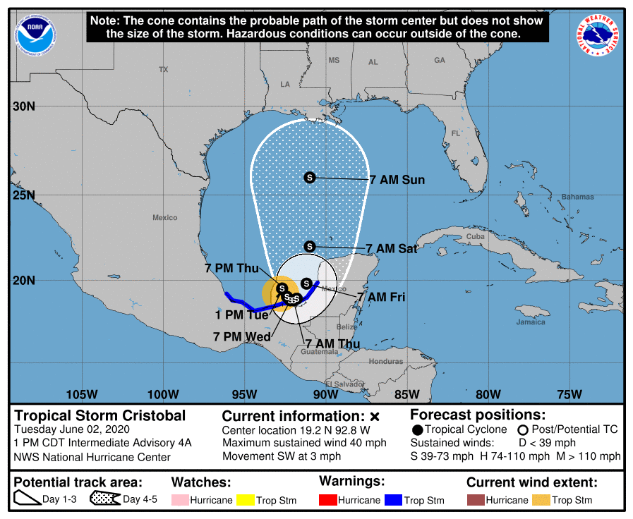
Good afternoon.
Below I've attached several graphics. First the latest NHC's track which is in line with the current model consensus. Next SE US live radar, then live satellite feed, then the current water vapor loop and lastly the current Surface Map. They are all of the same area and yet all differ in the information that they provide. On the radar you can clearly see Dorian's eye which has now expanded to 60 miles wide. In the satellite loop you can see how the eye is becoming better defined, in the Water Vapor loop you can best see the motion of the atmosphere that surrounds it. Due to the SE flow on the east side of the storm the frontal boundary to its north has become indented. If you look at the last diagram you can see where Dorian is headed. If you look at the isobar to the NE of Dorian you can see where it intersects with the coast just west of the Outer Banks. This is the center of its current track. Coastal North Carolina from Wilmington east are presently at greatest risk.
A Different Animal. As opposed to the Dorian we saw 2 days ago, strong and compact, Dorian now is a much larger, though fortunately weaker system. Hurricane force winds now extend 50 miles NE of the center, strong storm force winds (50-70 mph) 80 miles and weak storm force winds (40s) 160 miles to the NE of the Center. The Carolinas are going to have a tropical storm and coastal North Carolina probably a hurricane. Peak winds are anticipated to be in the 90-100 mph range. *** Note as it will be moving in the opposite direction of the winds the peak winds (out of the NE) will be reduced by its forward speed, if it accelerates this could significantly decrease the impact. *** Due to the wide eye it is unlikely that it is going to be a total miss. This should be primarily a coastal event and hopefully the strongest winds will stay off shore with the exception of the Outer Banks which will likely get clipped.
After it starts it's NE move tomorrow we'll have a better idea as to where precisely it will likely go.
Until tomorrow, Matt.