Matt on the Tropics
Tropical Updates
  • Home
  • About
  • Archive (pre-blog)
  • Contact
  • Weather Links
  • Weather Trivia

Tropical Update Friday 9-2-16, 7:30 am

9/2/2016

 
Good morning.

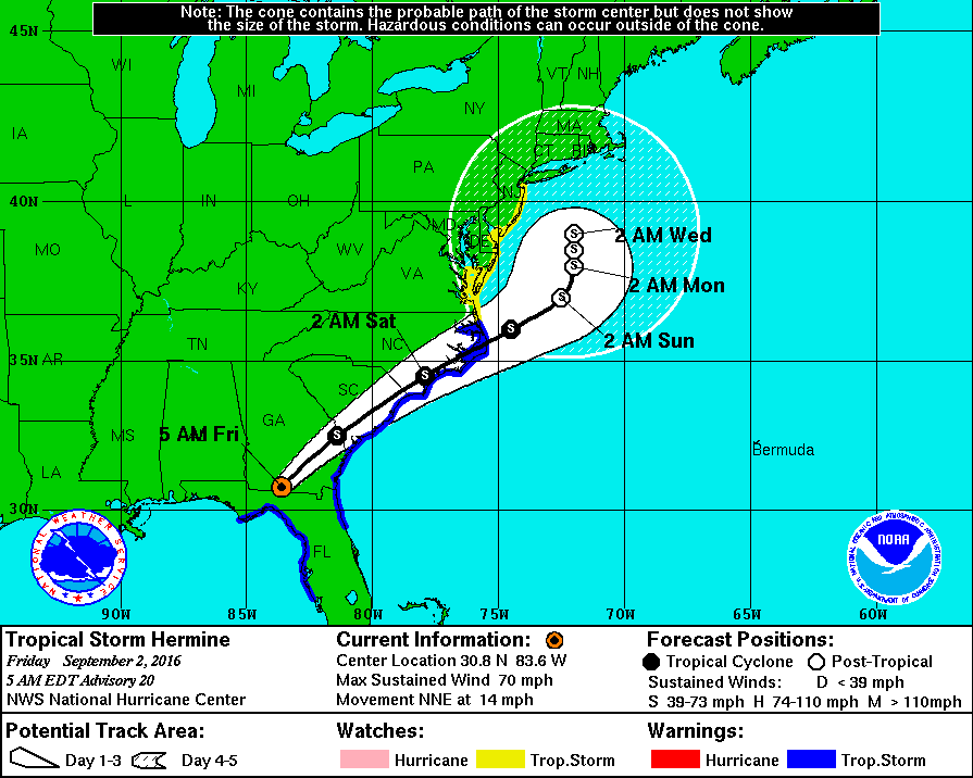
Hermine made landfall in the Big Bend area of Florida late last night as a Cat 1 Hurricane with 80 mph winds. It is currently a tropical storm over Southern Georgia. It is forecast to move through the Carolinas today and tomorrow and then stall off the NE coast early next week as an extra-tropical storm. This could become a huge rainmaker for New Jersey, Long Island and coastal New England with significant beach erosion. (see forecast track below). The low pressure area which I talked about in my last forecast is presently in the mid Atlantic centered around 15 degrees N latitude. It is surrounded by dry air and moderate shear. NHC is only giving it a 20% chance of becoming a tropical depression over the next 5 days as it enters the northern Caribbean Sea. I'll continue to keep an eye on it but hopefully it will not be a threat to South Florida. Elsewhere in the tropics TS Gaston is approaching the Azores and as is weakening and is expected to degenerate to a remnant low tomorrow.

Have a great Labor Day weekend.

Until next time,

                                                 Matt.

Picture

Tropical Update Tuesday 8-30-16,  8:30 am

8/30/2016

 
Good morning.

TD #9 continues to move west slowly and is expected to turn to the NW and eventually N and NE. The NHC has not revised its track since yesterday and yesterday's chart still holds. (see 8-29-16 forecast track/diagram). Pressures are dropping (29.62" last advisory) and the system is expected to become a tropical storm today. We should continue to see enhanced shower activity through Thursday due to higher atmospheric moisture associated with this system.

Of note is that the tropical wave which I wrote about yesterday moved off the African coast last night. Yesterday it moved SW and exited the coast at around 12 degrees N latitude. (see yesterday's post) 

 I'll be watching it.

Until next time,

                                         Matt.

Tropical Update Monday 8-29-16, 8 am TD #9

8/29/2016

 
Good morning.

At 8 pm yesterday Invest 99-L was upgraded to TD #9. At that time it was at it's closed approach to the Keys and was 60 mile S of Key West as it passed through the Florida Straits. It is currently located at 23.5 N & 83.9 W, see below, 155 miles WSW of Key West. Due to NW shear from an upper level low off the coast of N FL, GA and SC most of the weather associated with the system remains to the south and east of the center. This also left us with a mostly sunny and dry weekend other than a few passing showers. Rainfall total at my house for the weekend was just over 1/2 an inch. About normal for late August. The NHC models are in good agreement for the system to make landfall in the Big Bend area of Florida on Thursday. We will probably see enhanced shower activity through Thursday due to increased moisture in the area associated with this system. No significant winds are expected in South Florida. North Florida may see a tropical storm, though it is currently very poorly organized and shear is anticipated to persist making it unlikely to become a strong system.

A couple of points of interest if you go to this link ( http://www.goes.noaa.gov/HURRLOOPS/huwvloop.html ) now you will see Hurricane Gaston spinning in the mid Atlantic. It is a major Hurricane now with peak winds of 115 mph, ( Note you usually do not initially see a well defined eye on satellite imagery until winds get to around 100 mph.) The second point is that the area which we will need to watch is a tropical wave coming off of Africa. Another pearl is that waves coming off between 10 and 12 degrees N are the ones that tend to pose the greatest threats to South Florida, and the US for that matter. This one  is currently between 13-14 degrees.

We'll see how things develop.

Have a great week,             

                                                                       Matt.


Picture

Tropical Update Friday 8 am 8-26-16 Invest 99-L

8/26/2016

 
Good morning.

In reviewing the data on Invest 99-L this am the remarkable thing is that there is nothing there. It's circulation center is over the SE Bahamas w/o any associated weather near it. It is moving WNW @ 10 mph and should pass through the Florida Straits this weekend. Most of the associated moisture is to its south and east. Development of this system is extremely unlikely and the NHC has reduced it probability of development to 20% in 2 days and 60% in 5 days. I do not think we will experience any weather directly from this system. The old frontal boundary stalled across central Florida is the feature that has been causing our showers the past couple of days. It should persist and they may be enhanced by the moisture associated with this system as it passes to our south.

It is possible that it may develop after it gets into the Gulf of Mexico, but no preparations appear to be necessary for South Florida at this time. I will probably not write again until Monday, if it still exists, unless things should change.

Have a great weekend,

                                                    Matt.

Tropical Update 5 PM Thursday 8-25-16 Invest 99-L

8/25/2016

 
Good evening.

Since yesterday not much has changed with Invest 99-L which may be good news. It remains very poorly organized and its circulation center (currently near the Turks and Caicos) is exposed NW of most of its associated weather which is over and south of Hispaniola. It is presently experiencing 20-30 knots of shear which is causing this. The NHC has reduced its probability of development in the next 48 hours to 40%, and at 5 d to 70%. In 5 days it will be past us. In its current state it would take some time to get its act together. This makes the likelihood of a South Florida Hurricane low and it may not even make it to Tropical Storm status until it is past us. It is also possible that it may not even develop at all. It frankly looks very weak right now. (see below). By late tomorrow the shear above it will begin to subside and so slow development is possible. It is currently moving westward at 15-20 mph and at this speed should be in our vicinity Saturday night-Sunday.  High pressure over the NW Gulf should continue to move it  W to WNW. The NHC models as expected have begun to shift to the south (see below) and my track through the Florida Straits has not changed since yesterday. 

I'll write again tomorrow but the prospects of a significant storm for S Florida appears to be much less.

My best to all,   

                                    Matt.


Picture
Picture

 Tropical Update Wed 8-24-16 Invest 99-L, 8:30 AM

8/24/2016

 
Good morning.

Since yesterday things have changed quite a bit with Invest 99-L. In reviewing data this morning it appears that a tropical depression is currently forming. It remains under moderate shear in the NW Caribbean and development should be slow until it gets near Hispaniola. Yesterday there were 2 areas of spin, one to the north and one to the south, today due to greater shear to the north only the southern one remains and it has had significant convection over it overnight. The NHC forecast tract currently has Miami at the center of its cone. (see below). In looking at water vapor loops this am it appears to be heading more westerly than the NHC is projecting and I suspect we will soon see a shift in the models toward the south. An old frontal boundary across north - central Florida, will draw it toward the Florida Peninsula, high pressure to its north will tend to steer it to the west into the Gulf of Mexico.

My current track takes it through the Florida Straits near the Florida Keys. Note until it actually forms and a true center of circulation is determined and located precise tracks will be impossible to predict. I anticipate that it will cross the island of Hispaniola. The NHC has it passing to the north of it. Time will tell and the forecasts will fluctuate until a true course can be determined.

South Florida remains at risk with this system and I anticipate stores will be wild this weekend whether or not it affects us. I would recommend that every one go over you home hurricane plans and get whatever supplies which you may need today and tomorrow as you know things can get crazy here.

I will be writing daily about this system. Tomorrow probably in the afternoon. We should know more by then.

Matt.

Picture

Tropical Update Tues 8:30 am 8-23-16

8/23/2016

 
Good morning.

I am writing about a tropical disturbance which could potentially threaten S Florida in 5-6 days. It is currently labeled Invest 99L by the NHC. It currently is in a moderate shear environment and development will be slow to occur however once it reaches an area north of Hispaniola shear will slacken and development is quite possible. TD Fiona and TS Gaston will move off into the central Atlantic and not threaten us however Gaston's presence may limit this disturbance's ability to move further north. It is way too early to say whether it will develop or where it will eventually go however this will be one which we will need to watch. I've included the NHC's latest advisory about this system, a current satellite image and the NWS's current projected track. Note these will all change and should be taken with a grain of salt at this time.

" A large area of disorganized showers and thunderstorms located a few
hundred miles east of the Leeward Islands is associated with a
tropical wave.  Environmental conditions are somewhat conducive for
development of this system during the next couple of days while
it moves west-northwestward at 15 to 20 mph near the northern
Leeward Island and the Greater Antilles.  Large-scale conditions
could become more conducive later this week while the system moves
near Hispaniola and then the southeastern and central Bahamas. An
Air Force Reserve Hurricane Hunter aircraft is scheduled to
investigate this disturbance later this morning. Interests from the
islands of the northeastern Caribbean Sea to the Bahamas should
monitor the progress of this system.  Gusty winds, heavy rains, and
possible flash floods and mud slides could occur over these areas
regardless of tropical cyclone formation. Please consult products
issued by your local meteorological offices for further details.
* Formation chance through 48 hours...medium...50 percent
* Formation chance through 5 days...medium...60 percent   "

Picture
Picture

Tropical Update Wed. 8-17-16 08:00 TD #6

8/17/2016

 
 Good morning.

TD # 6 formed yesterday in the eastern Atlantic. It is currently located at 13.2 N and 35.2 W and is moving NW @ 15 mph with 35 mph winds. It is expected to become Tropical Storm Fiona later today. The NHC is currently forecasting it to head NW toward a weakness in high pressure to its north and miss the US entirely. In 2 days it will encounter significant shear and may dissipate. It is possible that the high pressure to its north could strengthen and push it further west, if it still exists, potentially threatening the US. Unless that happens I do not anticipate needing to write further about this system.


Matt.

Tropical Update Monday 8-1-16 08:00

8/1/2016

 
Good morning.

I am writing about a well defined tropical system currently just south of Hispaniola which will likely become Tropical Storm Earl later today or tomorrow. The NHC is giving it a 70% chance of development within the next 48 hr. Winds of gale force are already present. In reviewing data this morning it appears to be headed towards the Yucatan Peninsula and likely will not make a US landfall. The NHC models are currently centered on Belize, however I would anticipate a landfall along the North - Central Yucatan coast. Unless things change I do not anticipate the need to write further about this system.

My best to all,

Matt.

Tropical Update June 6, 6:00 am, Tropical Storm Colin

6/6/2016

 
Good morning

At 5am TS Colin was located at 25.2 N and 87.4 W with 50 mph winds and was moving NNE at 14 mph. The upper level wind pattern has not changed and Colin should proceed as previously forecast. The NWS/NHC has been right on with this one and I anticipate landfall in the Big Bend area of North Florida early tomorrow morning. Significant shear should hamper significant intensification and the NHC is currently forecasting it to make landfall as a 60 mph Tropical Storm.
It is pretty much due west of Miami now and SE Florida should see minimal weather from this system. Probably some rain later today and tonight. Not much wind.

Until next time,

Matt.
<<Previous
Forward>>

    Categories

    All
    Preseason Update