Matt on the Tropics
Tropical Updates
  • Home
  • About
  • Archive (pre-blog)
  • Contact
  • Weather Links
  • Weather Trivia

tropical update Saturday 8-22-20, 7 am

8/22/2020

 
Good morning.

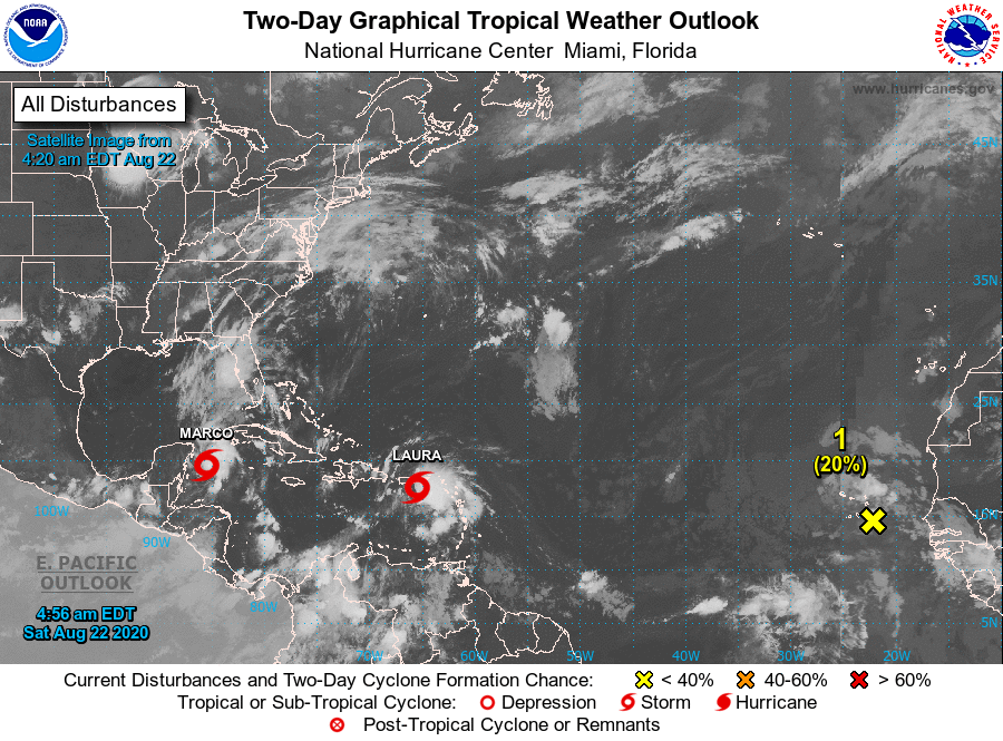
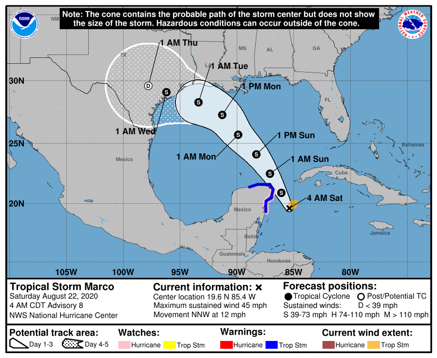
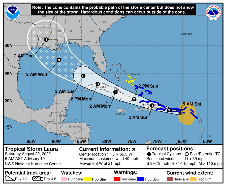
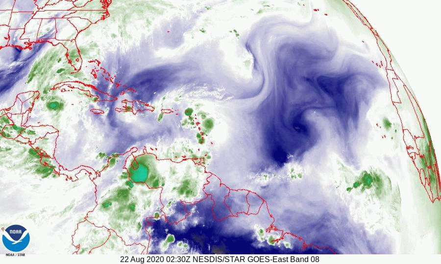
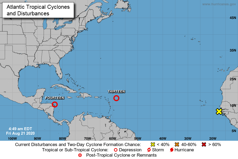
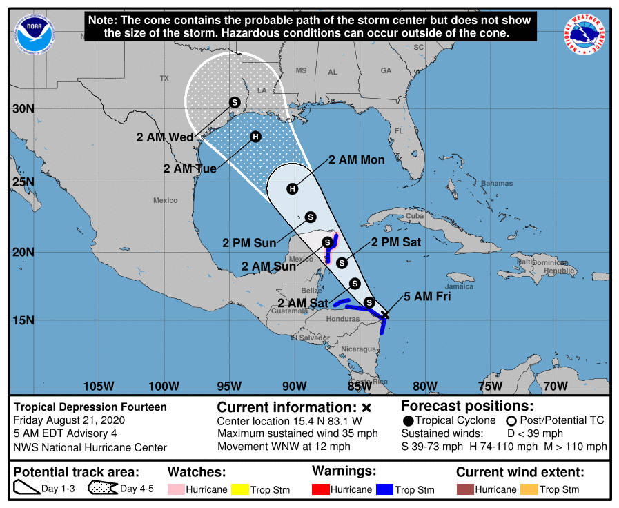
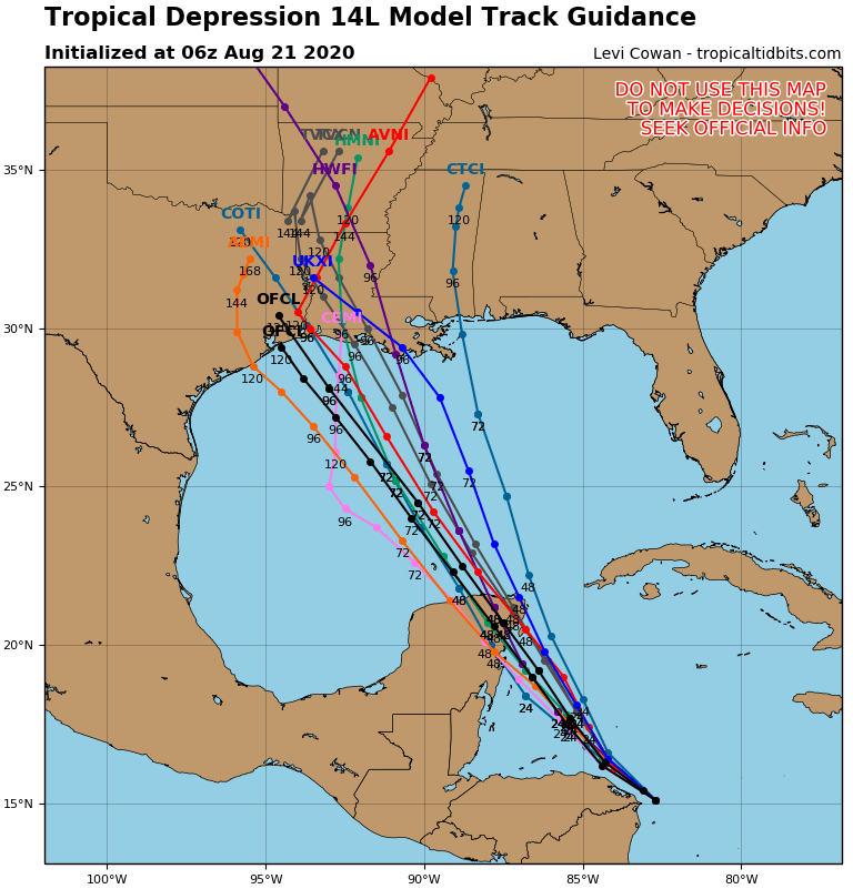
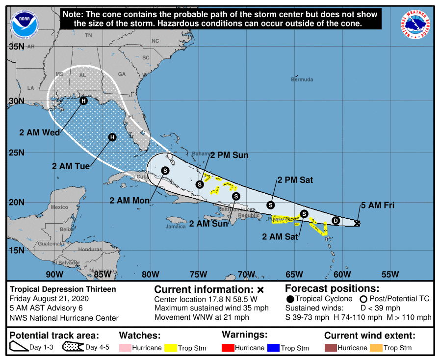
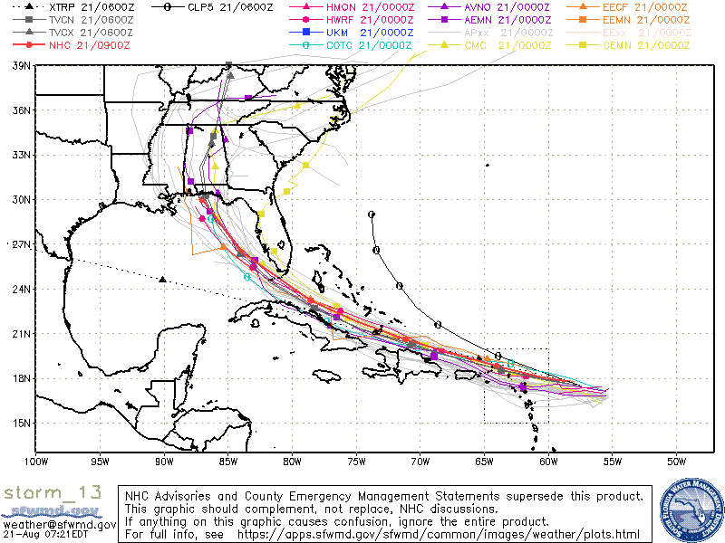
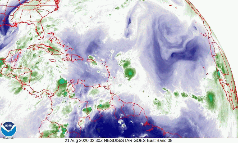
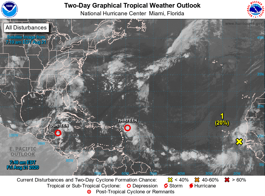
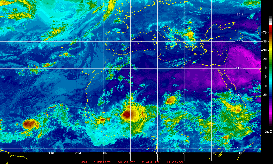
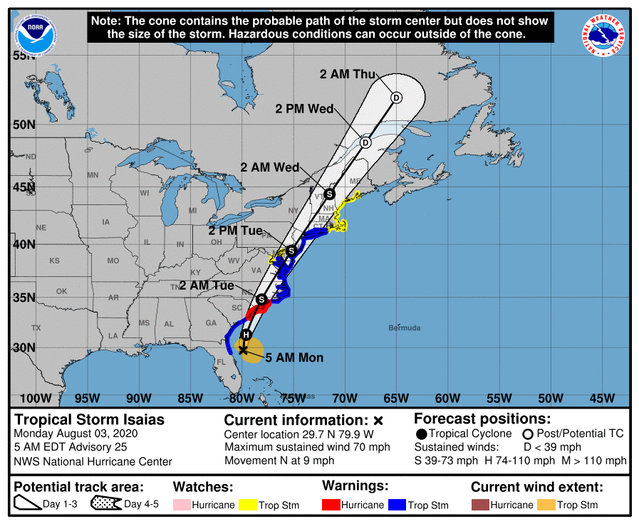
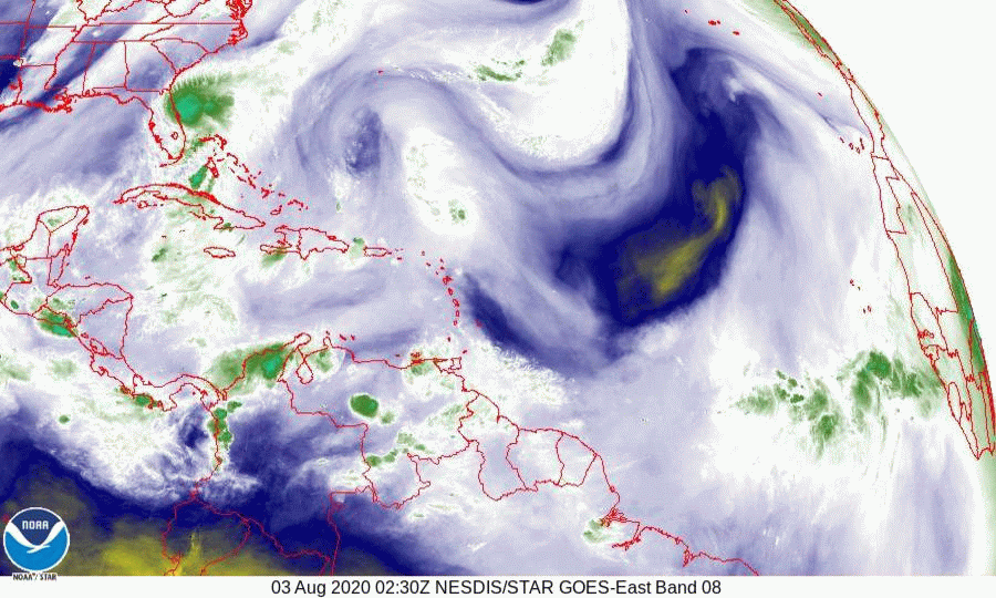
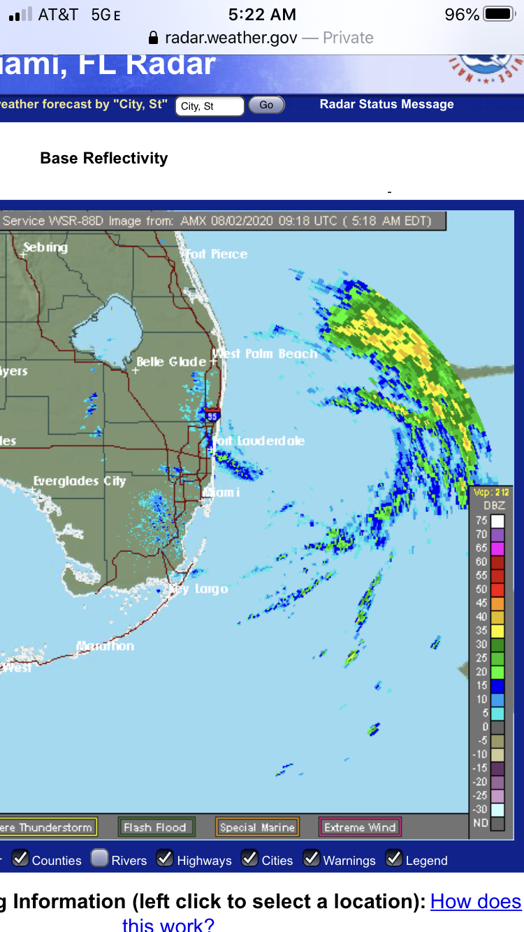
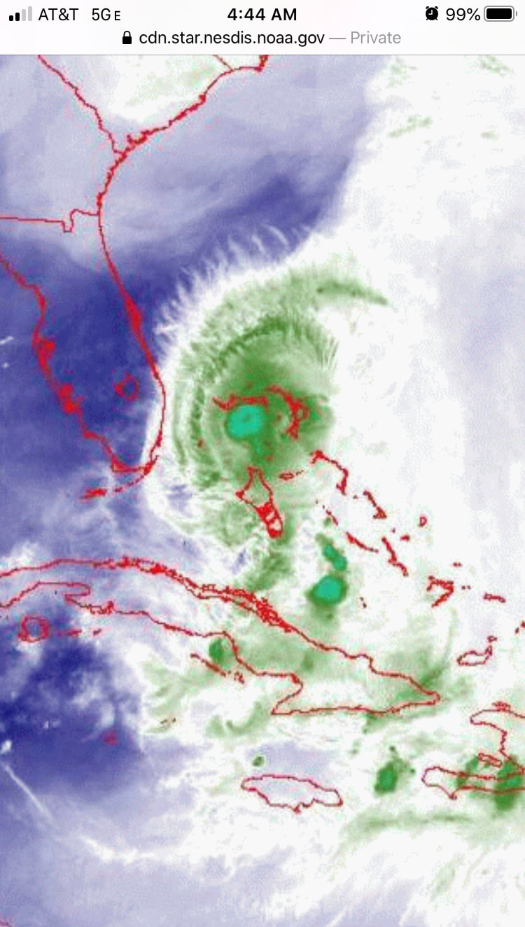
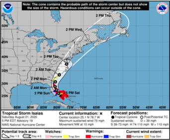
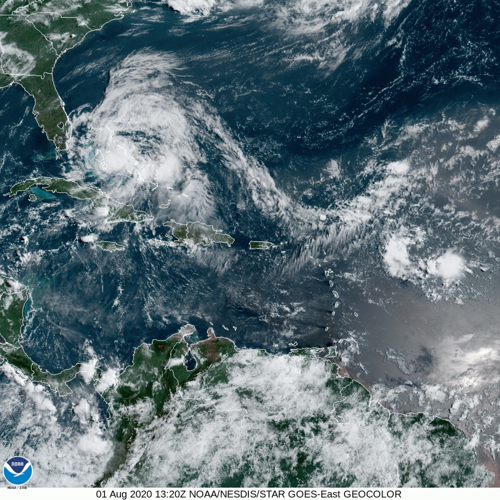
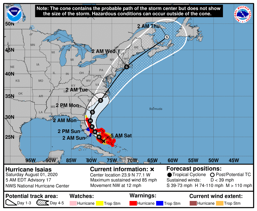
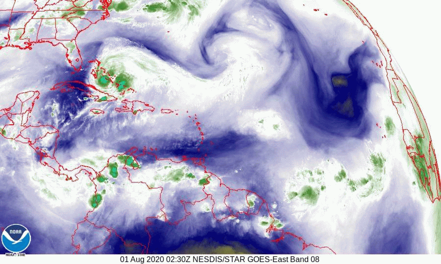
Yesterday afternoon hurricane hunters relocated Laura's eye around 100 miles south of where they had previously thought it was. (See yesterday's forecast about TD# 13 being uncoupled and weak storms being tricky.) This changed everything because as opposed to being in the Atlantic Laura is in the Caribbean. See water vapor loop below. It has moved almost due west over the past 24 hours and is well south of yesterday's forecast track. The current NHC track has it crossing the spines of the Caribbean islands of Puerto Rico, Hispaniola and Cuba. This will lead to Laura remaining weak until it emerges into the Gulf of Mexico.  It is currently forecast to hit Louisiana as a Cat 1 hurricane. Laura remains weak with multiple vortices moving around its current center and one of the concerns is that we may see new eyes reform after it crosses over the islands which could again change its track. (Like what happened with Isaias.)

On its present track I do not anticipate storm or hurricane conditions in the state of Florida.

Elsewhere all else is quiet. The wave off of Africa, currently in the region of the Cape Verde Islands, is probably already too far north to pose a threat to the US. I'll be watching it but my concern is much less at this time.

Have a good weekend !

Until next time,       
                                      
                                                   Matt.


Picture
Picture
Picture
Picture

tropical update Friday 8-21-20, 7 am

8/21/2020

 
Good morning. 

Over the past couple of days there have been some interesting developments, though both systems are still very poorly organized. Neither currently appear to pose a significant risk to South Florida.

If you look at the water vapor loop, bottom diagram you will see an upper level low centered along the northern Gulf Coast near the Louisiana - Mississippi border. This is associated with a stationary front along the northern Gulf. ( see surface map of Gulf of Mexico below.) This will be the main factor steering both of these systems. One will come in on its back side the other just on its front side. The wild card which is totally unpredictable at this time is the interaction which will occur between the two systems as they start to approach each other and the northern Gulf of Mexico on Monday and Tuesday. See Fujiwhara Effect in Weather Trivia Section of this Blog.

Of the two only TD #13 should have an affect on Florida. It is currently tracking south and west of NHC's projected path from yesterday and the NHC has adjusted their track accordingly. The model consensus brings it through the lower Florida Keys then toward the Florida - Alabama border near where the stationary front nips the Panhandle. If this track holds it would pass around 100-120 miles SW of the Miami area. Its weak tropical storm force wind field to the NE at that time is projected to extend 110 miles, therefore the southern parts of Miami-Dade County may experience winds in the 30-40 mph range in squalls and 2-4" of rainfall.

Its still too early to make an accurate prediction. TD #13 is currently uncoupled with a mid level center several hundred miles SE of the low level center. As we saw with Isaias weak systems can be tricky.

Frankly the one I'm concerned with is the one just off the coast of Africa now, but its way too early to say anything about it.

I'll write again tomorrow,  

                                                              Matt.
​
Picture
Picture
Picture
Picture
Picture
Picture
Picture
Picture
Picture

tropical update Monday 8-17-20, 7:30 am

8/17/2020

 
Good morning.

I'm writing about 2 areas of disturbed weather that we'll need to watch though neither appears to present a significant threat to South Florida at this time. Both are very far south in the central and eastern Atlantic, see 2 day outlook below, one just north and one just south of 10 degrees latitude.
If you look at the surface map below you will see that the western one will tend to be steered toward Central America and the Yucatan, after which it should slow down and then turn north toward the Florida Panhandle or the west coast of Florida. The eastern one should approach the NE Caribbean and then turn NW, then N and NE just to the east or over the Central and Northern Bahamas.
Fortunately neither is well organized and there is a lot of shear between them and Florida or the Bahamas and they may not even form or dissipate. However if they should make it to the Gulf of Mexico or the Bahamas shear will lessen in those areas and development could occur. We'll have to see.

A moist light S to SW flow over Florida this week should lead to enhanced shower activity along the Florida east coast.

Until next time,      

                                                 Matt.


Picture
Picture
Picture
Picture

tropical update Friday 8-7-20, 7 am

8/7/2020

 
Good morning.

Just a quick update. Currently things are quiet however there are two areas which we'll need to watch. The first is in the east-central Atlantic at around 9 degrees latitude. The second is a strong tropical wave over Africa at around 12.5 degrees. See satellite image of the Atlantic and infra red image of Africa and the Eastern Atlantic below. The first is fair far south and would have a low probability of making it to South Florida. The second is in the window that we need to watch  (10-12 degrees). It should come off the coast in about 3 days. I'll be watching it. After those two there is nothing else in the pipeline over Africa for at least another week.

Until next time, 

                                           Matt.
​
Picture
Picture

tropical update monday 8-3-20, 7:30 am

8/3/2020

 
Good morning.

TS Isaias is currently located east of Jacksonville. See 5 day NHC forecast and water vapor loop below. Fortunately Isaias did not make a Florida landfall and remained offshore as expected. In addition due to strong SW shear most of its weather remained offshore. Peak winds yesterday in Miami were 17 mph with gust to 25. West Palm Beach had a peak wind of 31 mph with a gust to 43. Melbourne when it was at closest approach had winds of 20 mph with a gust of 32. Florida only experienced weak tropical storm conditions.

Rainfall at my house over the weekend totaled 1.68", within my expected 1-2" forecast range.

Elsewhere all else is quiet. A weak disturbance in the Atlantic will move out to sea, even if it should develop. There are a couple of strong waves over Africa which we'll need to watch in a week or two.

Until next time,                  Matt.
​

PS. Hopefully if you were following you were not part of the panicked crowds out there.

Picture
Picture

Tropical update sunday 8-2-20, 5 pm

8/2/2020

 
Good evening,

​ At 5 PM Tropical Storm Isaias was located east of Melbourne. See radar image below. Isaias has been moving just slightly west of due north all day and has remained offshore, and due to strong south west shear almost all of its associated weather has remained well offshore sparing Florida from most of its weather.

Until next time,

​Matt. 


Picture
Picture

TROPICAL update 8-2-20, 5 am

8/2/2020

 
Picture
Good morning. 

At 4:30 AM tropical storm Isaias was located just east of Boca Raton Florida. Isaias has become uncoupled. Even though the center may pass over or near the coast all the weather is displaced, due to shear, north east of the center with the main area of convection just south of Grand Bahama island. 
Areas from Jupiter and north should prepare for tropical storm conditions however if it remains uncoupled Florida  may not receive much significant weather.

I’ll post again this afternoon,

Matt.


Picture

Tropical Update Saturday 8/1 6:00 pm

8/1/2020

 
Good evening. This morning now tropical storm Isiais was moving Northwest on the east side of Andros Island and was approaching Nassau. Late this morning and this afternoon, it took an unexpected jog/wobble 60-70 miles Westward along the North coast of Andros Island. It has now resumed its Northwest motion, however in light of this, the models and NHC track have shifted back Westward. It appears it will either come ashore or just barely skirt the East central coast of Florida, possibly making landfall in the Jupiter area. Most of its weather remains on the East side of the storm. It is forecast to regain minimal Cat 1 status tonight. It should be at its closest approach to the Miami area at approximately 10 pm tonight and should be approximately 80 miles off shore. I would not anticipate much weather for Miami-Dade County however Stuart and North will probably experience strong Tropical Storm conditions. 

I'll write again tomorrow. Until next time, Matt
Picture
Picture

Tropical update SATURDAY 8/1/20, 5 am

8/1/2020

 
Good morning.

At 4:30 this morning Hurricane Isaias was moving through the central Bahamas. In looking at the water vapor loop it looks like it will pass just east of Andros Island in the direction of Nassau and Grand Bahama Island. If it crosses over Grand Bahama it should miss the state of Florida and I still do not anticipate hurricane conditions in the state.

At 5 AM the NHC track has shifted slightly to the East and is now just off the Florida East Coast. My track is unchanged and crosses Grand Bahama keeping hurricane force winds offshore.

I will be watching it throughout the day and will make another post late this afternoon, after the 5 PM advisory.

Until next time,
Matt
Picture
Picture

Tropical update friday 7/31/20, 8 pm

7/31/2020

 
Good evening.

At 8 pm Isaias was located over the Central Bahamas and was moving NW at 15 mph. Since this morning the NHC has moved its track westward due to greater strength of the ridge to its NE and slower than expected movement of the frontal system moving eastward across the US. They are calling for it to come ashore in the Jupiter area and then move along the coast. The window between the high pressure ridges to its NE and NW really has not changed much and my track remains east of theirs crossing western Grand Bahama in the Freeport area and remaining off the Florida coast. 
On the NHC’s track it would pass around 100 miles east of Miami late tomorrow night. Anticipated winds would be in the 20s - 30s with gusts to around 40. Cat 1 hurricane conditions would occur from Stuart north.
I anticipate that we will see a shift in the models tomorrow a little further east. It should slow down as it approaches. This should also allow it to start to move NNW and eventually N and NE.

I’ll write again tomorrow.

Until  then ....Matt.
Picture

​​

<<Previous
Forward>>

    Categories

    All
    Preseason Update