Matt on the Tropics
Tropical Updates
  • Home
  • About
  • Archive (pre-blog)
  • Contact
  • Weather Links
  • Weather Trivia

tropical update Friday 9-18-20, 7 am

9/18/2020

 
Good morning.

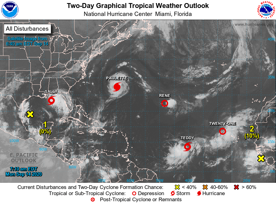
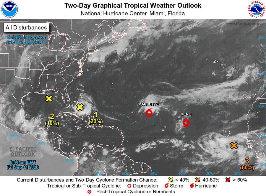
The tropics remain active this morning. Sally made landfall on Wednesday morning as a Cat 2 near Gulf Shores Alabama, between Mobile Bay and the Florida/Alabama state line.

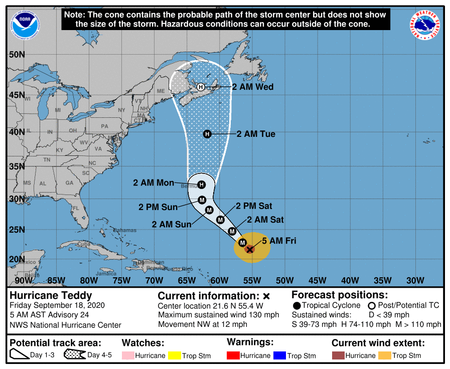
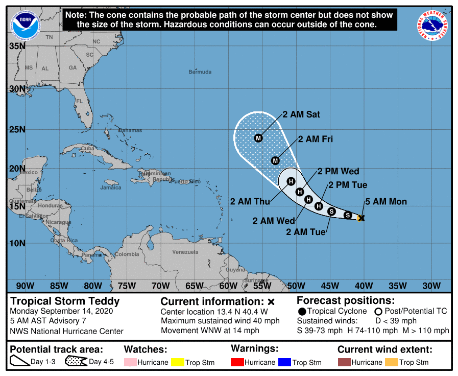
Teddy currently a Cat 4 is heading toward Bermuda and Nova Scotia. It should pass east of Bermuda but could be close. Its too soon to say about Nova Scotia.

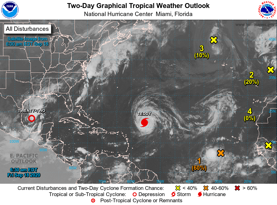
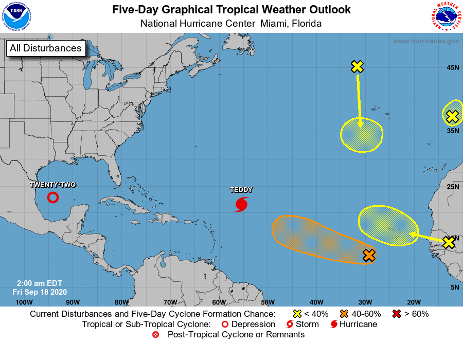
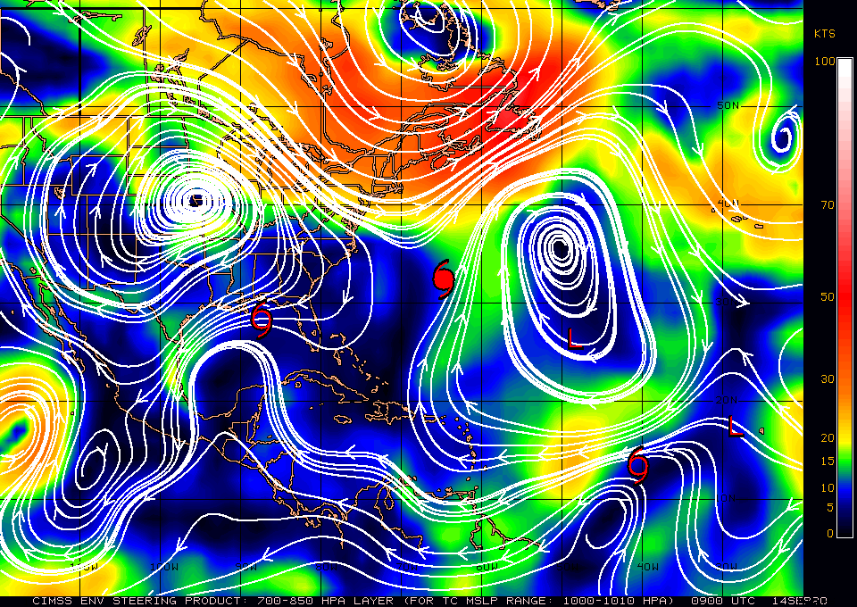
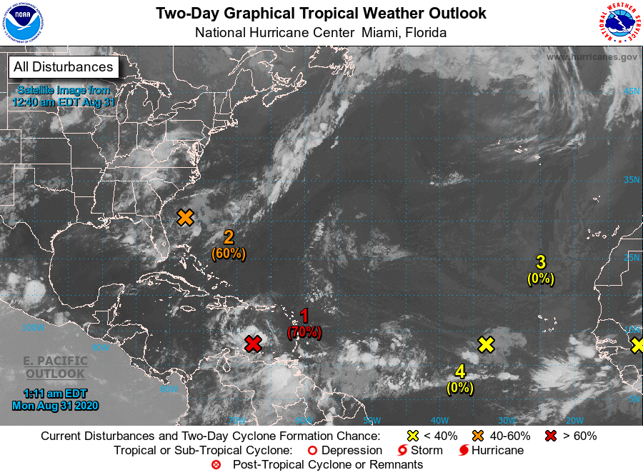
The orange X below should become TD #23 soon and should follow in Teddy's wake, out to sea. If you look at the surface map below a prominent window remains between the high pressure just east of Florida and the one in the Central Atlantic. If this persists it should continue to protect the southern 1/2  and east coast of the state of Florida.

If you look at the Infra Red image of Africa below you will see little activity over the continent. The Cape Verde season is almost over. After the current batch we will probably not see many. The Cape Verde season usually ends around the beginning of October.

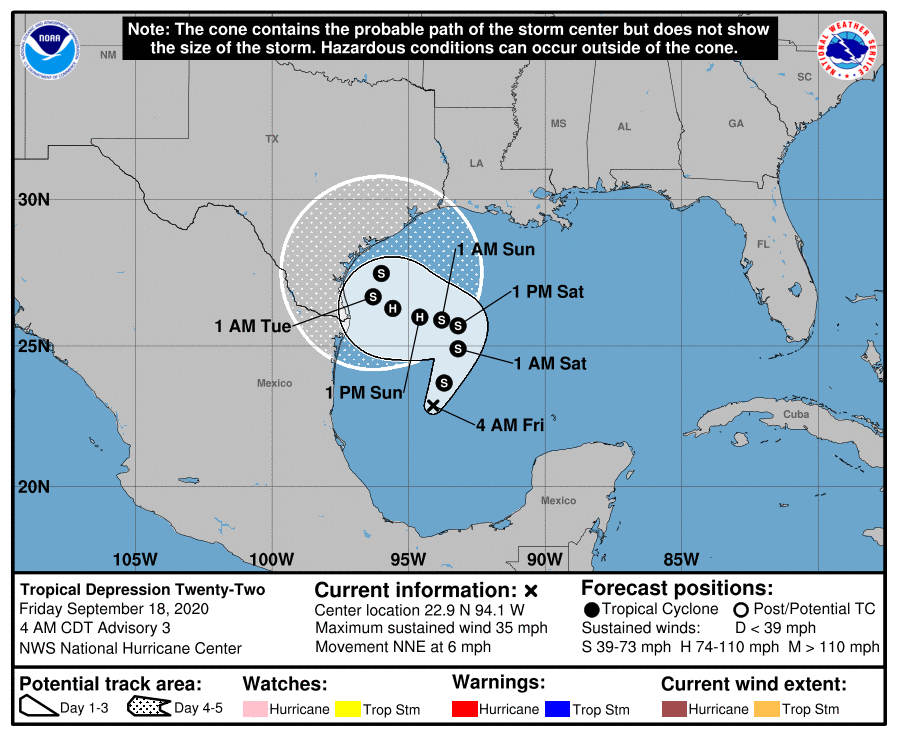
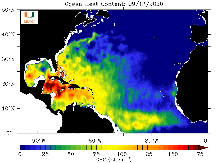
If you look at Sea Surface Temperature and Ocean Heat Content (influenced by water temps and the depth of the warm water) diagrams below you can see that the next areas to watch will be the Western Gulf of Mexico, where TD #22 is now, and the Western Caribbean. Their season usually starts early October to early November.

Until next time,
 
                                                                   Matt.

​
Picture
Picture
Picture
Picture
Picture
Picture
Picture
Picture

tropical update monday 9-14-20, 7 am

9/14/2020

 
Good morning.

The tropics are active this morning, though Florida remains at low risk.

Sally formed on Saturday, AFTER crossing South Florida giving us a rainy Saturday as forecast. It is currently forecast to make landfall in Mississippi tomorrow PM as a Cat 1 hurricane.

The NHC has changed its forecast on Teddy, formerly TD# 20, and it is now forecast to follow in the wake Paulette and Rene and move out to sea. I wrote about that on Friday.

TD# 21 is too far north and is forecast to dissipate, as is Rene. 

Paulette, a Cat 1 hurricane, is in the region of Bermuda and is moving out to sea.

We'll need to watch the tropical wave just off the coast of Africa, however if you look at the surface map below, bottom diagram, you'll see a broad window between the Bermuda High and high pressure over the Central US which would tend to steer anything that enters the Caribbean or SW Atlantic out to sea, likely east of the Bahamas.

So far so good. A strong wave over Central Africa should emerge off the coast in 4-5 days. I'll be watching.

Until next time,                                    Matt.

​PS. Don't be intimidated by all these storms out there. Its actually good as each one diminishes the heat content of the ocean a little bit. Some more than others.
Picture
Picture
Picture

tropical update friday 9-11-20, 7 am

9/11/2020

 
Good morning.

We are currently at the peak of Hurricane Season and things in the tropics are heating up though Florida still looks okay. A tropical wave currently over the Bahamas will move over South Florida tonight and tomorrow. Tomorrow should be a rainy day with frequent showers. It has potential for development AFTER it enters the Gulf of Mexico. Paulette and Rene are moving out to sea. The one that we'll need to watch is the area just off the coast of Africa. If it stay far enough south it may miss the Mid Atlantic Trough and enter the Caribbean or Florida Straits. The high pressure that was over Florida last week has shifted north and the current "windows" are open through the Caribbean and Florida Straits. See surface map below. 
Hopefully it will be drawn north into the wake of Paulette and Rene and move out to sea, but we'll have to see.

Until next time,                           Matt.

​
Picture
Picture
Picture

tropical Update friday 9-4-20, 10 am

9/4/2020

 
Good morning.

See below. We're still OK.
​High pressure over Florida is currently protecting the state.

Matt.
Picture
Picture

tropical update monday 8-31-20, 7 am

8/31/2020

 
Good morning.

Just a quick update. There are several systems out there though none currently pose a threat to Florida. High pressure just north of the Yucatan Channel should protect the state. The system in the Caribbean should be steered toward the Yucatan Peninsula. Those in the Atlantic should move east of Florida, possibly affecting the Bahamas though likely missing them as well.

I'll be watching and let you know as things develop, or not.

Until next time,               Matt.


Picture
Picture
Picture

tropical update friday 8-28-20, 8 am

8/28/2020

 
Good morning.

Laura made landfall early yesterday morning as a strong Cat 4 with 150 mph winds and a barometric pressure of 937 mbs, just east of the Texas - Louisiana state line in the region of Cameron, LA. Our thoughts are with those who live in that area, having been through that ourselves.

Elsewhere in the tropical there are a couple of weak systems what I'm watching though none currently pose a threat to Florida. High pressure over the Central Bahamas just east of South Florida should protect most of the state except the Panhandle, see surface map below. Dry air over the western tropical Atlantic and the Caribbean should help us as well.

The main area of concern is Africa where you can see on Infra Red image an active pipeline of storms moving across tropical Africa. These will become the ones to watch over the next 1 - 2 weeks as we approach the peak of hurricane season.

Until next time,                 Matt.


Picture
Picture
Picture
Picture

tropical update Wednesday 8-26-20, 7 am

8/26/2020

 
Good morning.

Hurricane Laura is currently spinning in the central Gulf of Mexico. The NHC is currently forecasting it to become a 130 mph Cat 4 hurricane later today and to make land fall as a 120 mph Cat 3 at around 1 am tonight. The NHC has not changed its track, nor have I. My forecast from yesterday still holds. The upper level low which I talked about yesterday is now south of Cuba, and contributing to its NW motion.

Galveston is currently under a mandatory evacuation. If you'd like to read an amazing story about the deadliest hurricane in US history, read "Isaac's Storm", a true story about the meteorologist in Galveston in 1900, who forecast the coming hurricane with only rudimentary information at the time and his description of the devastation that followed that 150 mph hurricane. Storms were not named at that time, it is known as the Great Galveston Hurricane of 1900. It came ashore on September 8th, 1900.

Until next time,
                                                             Matt.

​
Picture
Picture

tropical update tuesday 8-25-20, 7am

8/25/2020

 
Good morning.

Marco has dissipated and TS Laura is currently moving through the Yucatan Channel. The current NHC track brings it to the Louisiana/Texas border early Thursday morning as a 115 mph Cat 3 hurricane. If you look at the bottom diagram, water vapor loop, you can see a large upper level low just north of the Windward Passage moving west. This has been the main feature which has pushed Laura more south and west than had been forecast and I believe it will continue to influence its track. In light of this my current track is west of the NHC's bringing Laura ashore between Galveston Bay and Sabine Pass Texas. Everyone in this area should prepare for major hurricane conditions. There is one significant variable in play regarding intensity. If you look at the water vapor loop of the Gulf of Mexico you will see strong upper level SW winds along the Texas coast, this is shear and could potentially weaken Laura just prior to landfall. We'll have to see.

​Elsewhere all is quiet.

Until next time,

                                                         Matt.

Picture
Picture
Picture
Picture
Picture
Picture

tropical update monday 8-24-20, 7 am

8/24/2020

 
Good morning.

Today is the 28th anniversary of Hurricane Andrew which made landfall across  Miami-Dade County on 8-24-92. A day most of us will never forget.

​If you look at the water vapor loop below you can see both TS Laura and TS Marco. Laura is now south of Cuba and is experiencing shear out of the north. In light of this South Florida will see very little rain today. It will be due south of Miami at around 11 am today and at its closest approach. Marco is experiencing shear out of the SW and has very little weather near its center. In light of this it is forecast to remain a tropical storm.

See NHC forecast tracks below. The real risk for the northern Gulf Coast is Laura which is forecast to cross over both the Gulf Stream and the Gulf Loop Current with very warm water. Though the current forecast advisory is for peak winds to 95 mph there is the possibility of it becoming a major hurricane. What happens tomorrow and Wednesday will be the key.

Until next time,                             Matt.

Picture
Picture
Picture

tropical Update Sunday 8-23-20, 7 am

8/23/2020

 
Good morning,

See charts below - it looks like Louisiana will be receiving unprecedented back-to-back hurricanes early this week. Marco is forecast to come in as a Cat 1 and Laura as a Cat 1 or 2, but we will have to see regarding intensity.

All that I anticipate for South Florida is a breezy day tomorrow with passing showers.

Until next time,
​Matt
Picture
Picture
<<Previous
Forward>>

    Categories

    All
    Preseason Update