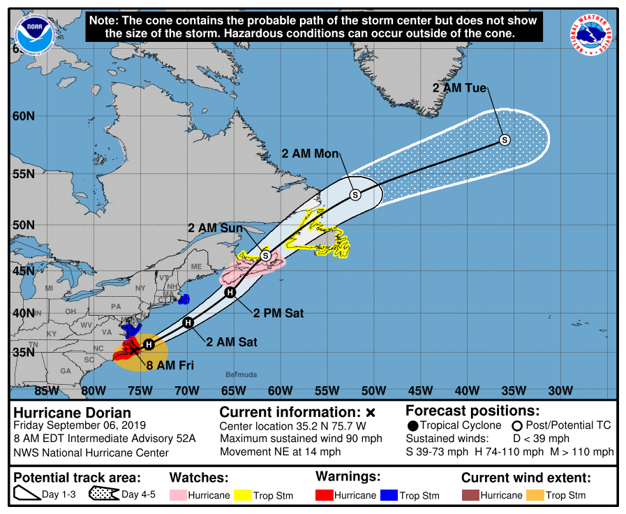
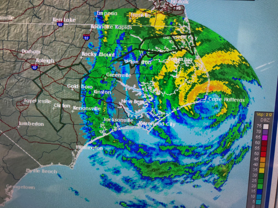
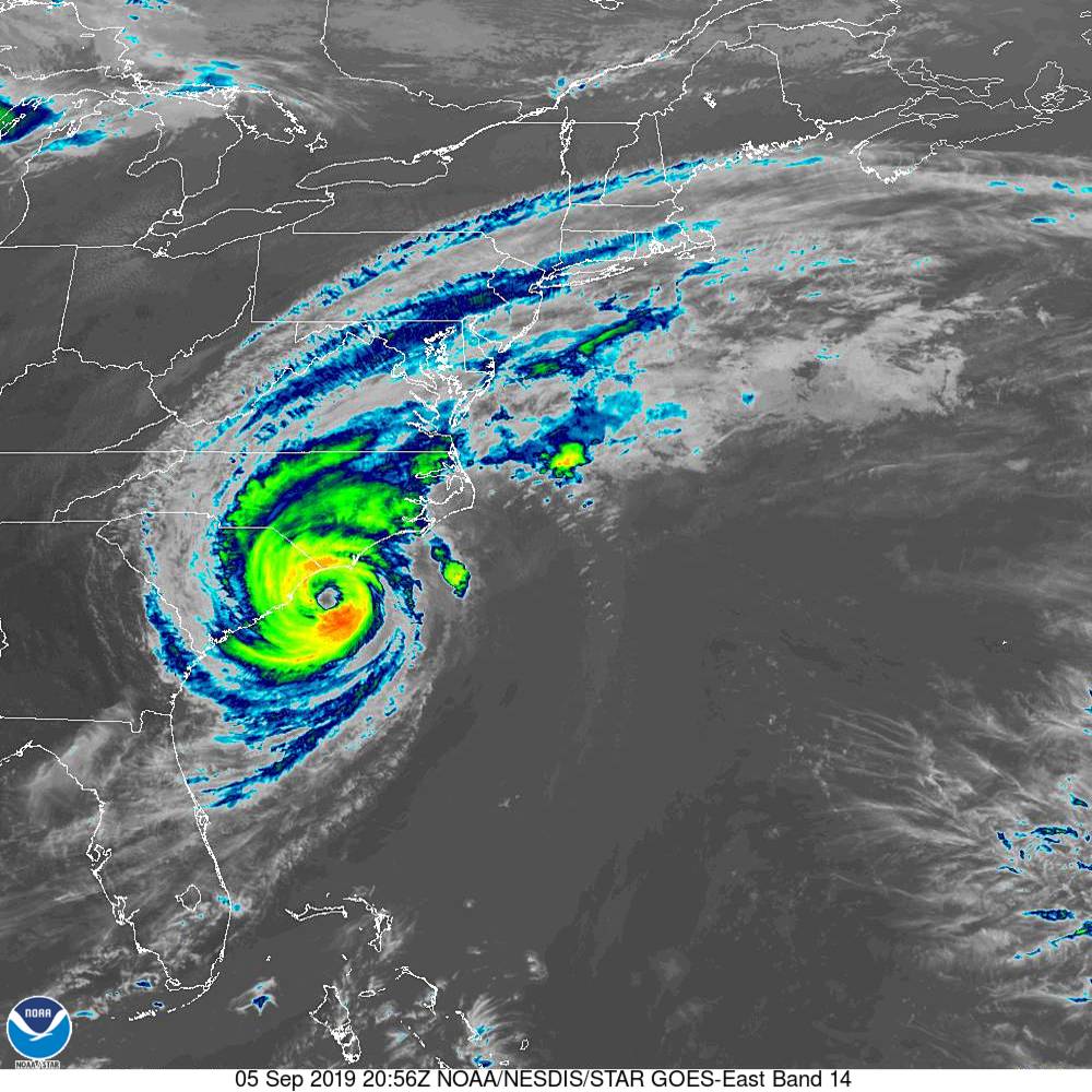
Matt on the Tropics
Tropical Updates
  • Home
  • About
  • Archive (pre-blog)
  • Contact
  • Weather Links
  • Weather Trivia

Tropical update thursday 9-12-19, 7 pm

9/12/2019

 
Good evening.

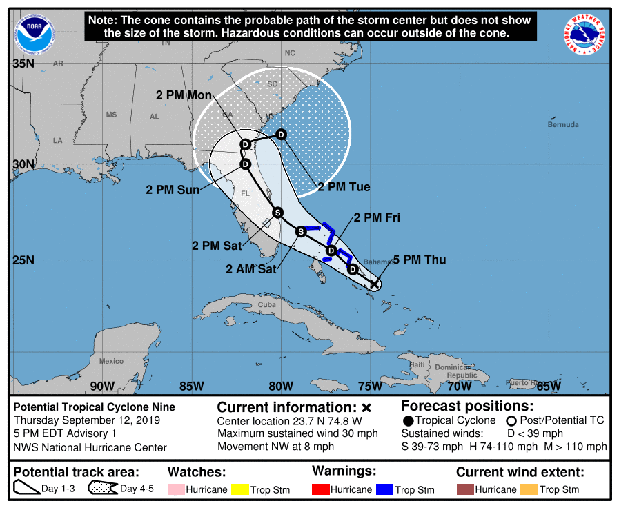
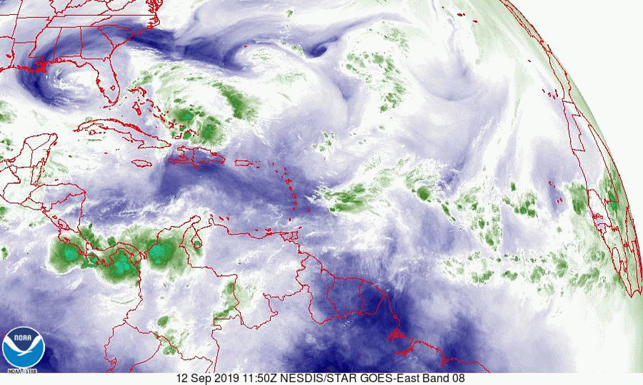
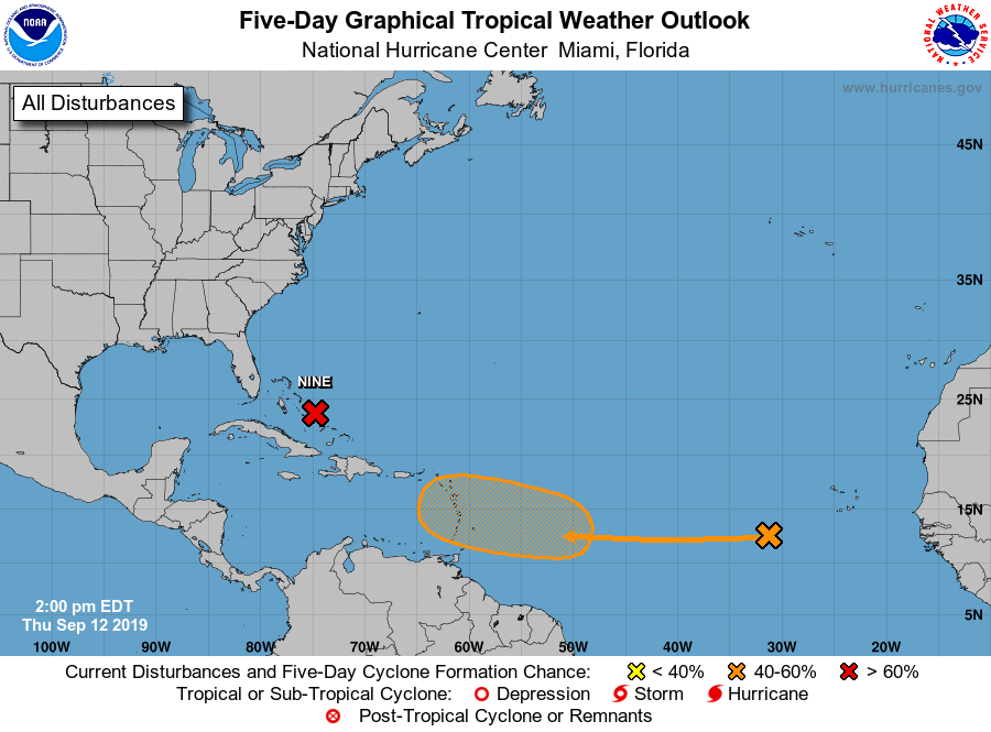
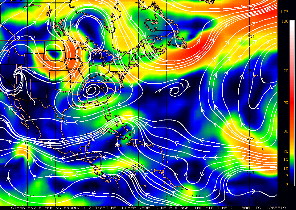
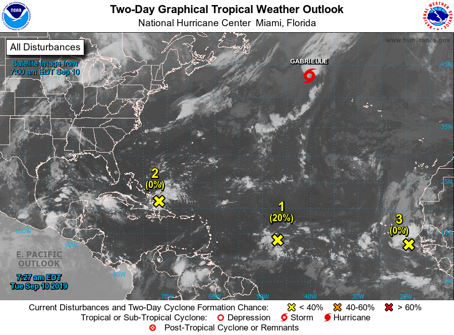
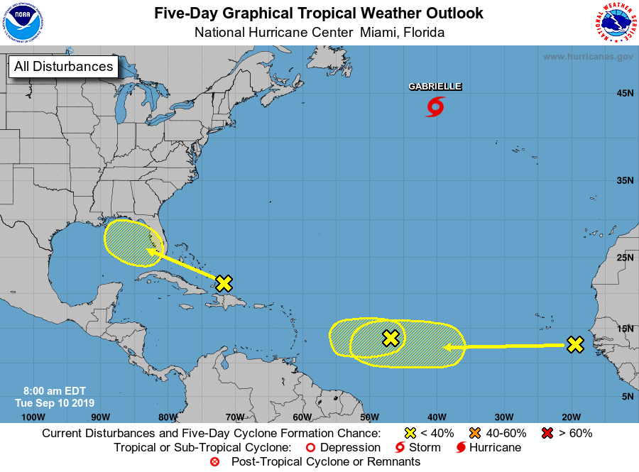
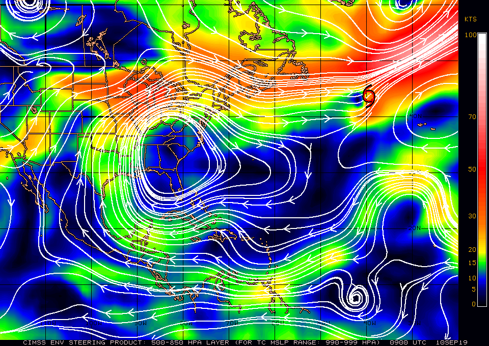
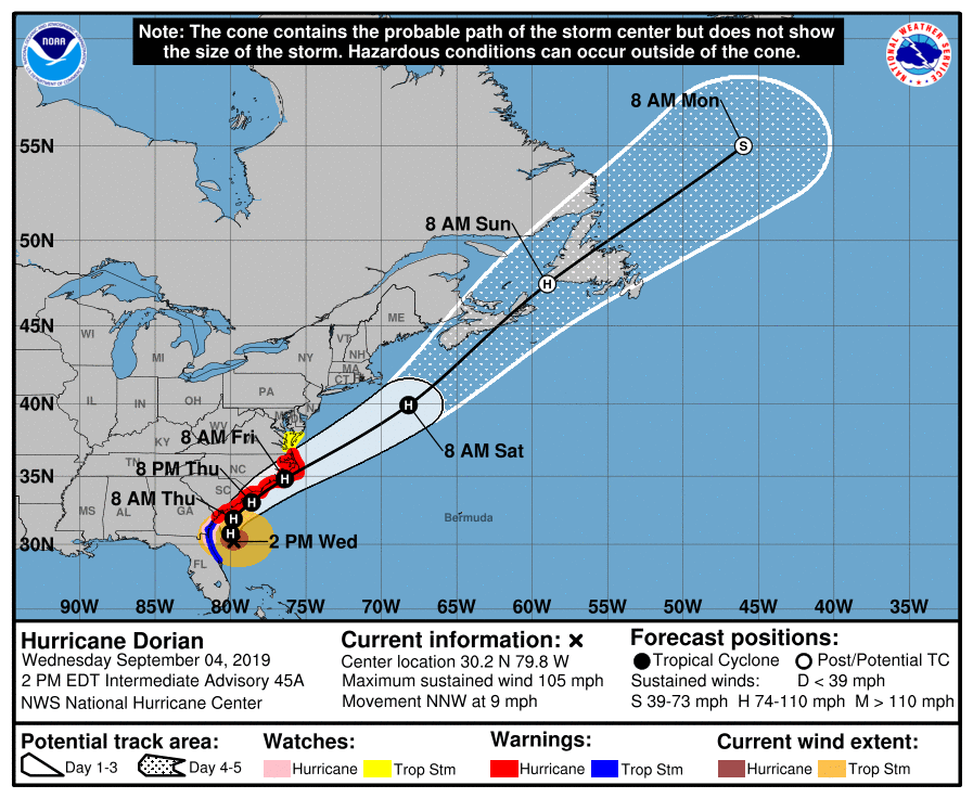
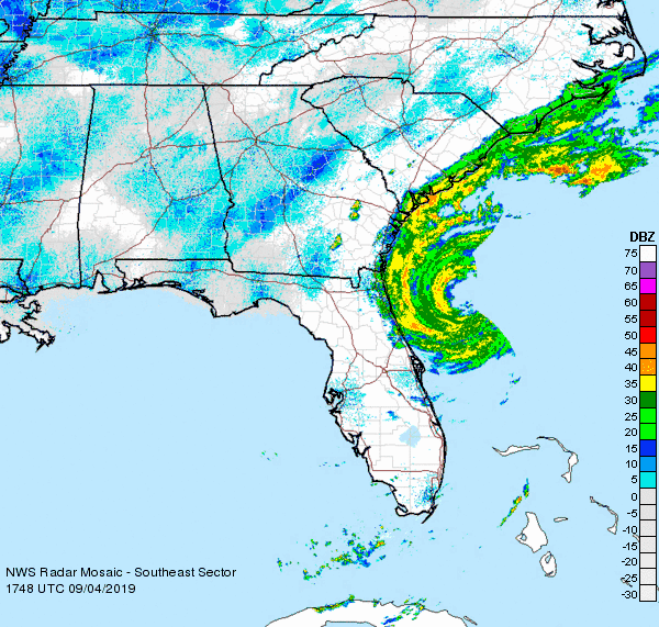
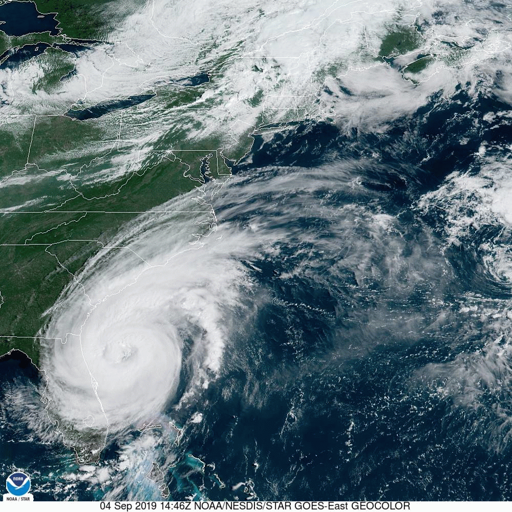
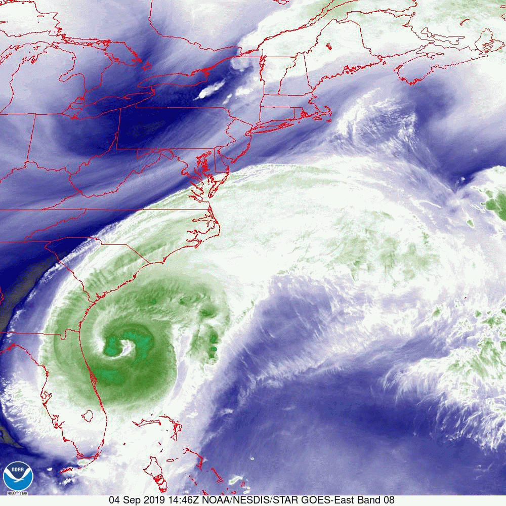
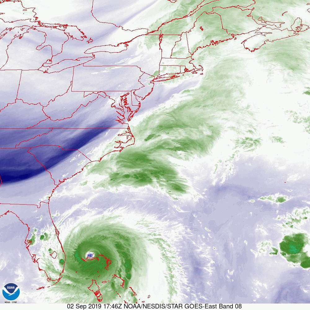
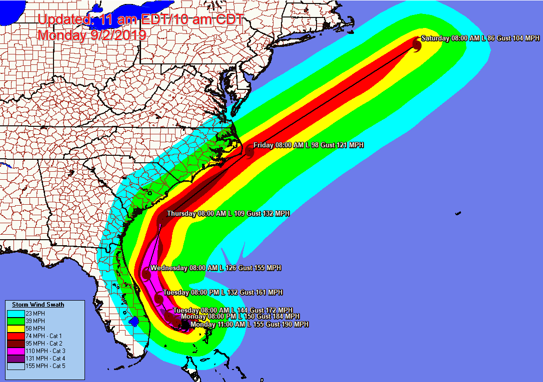
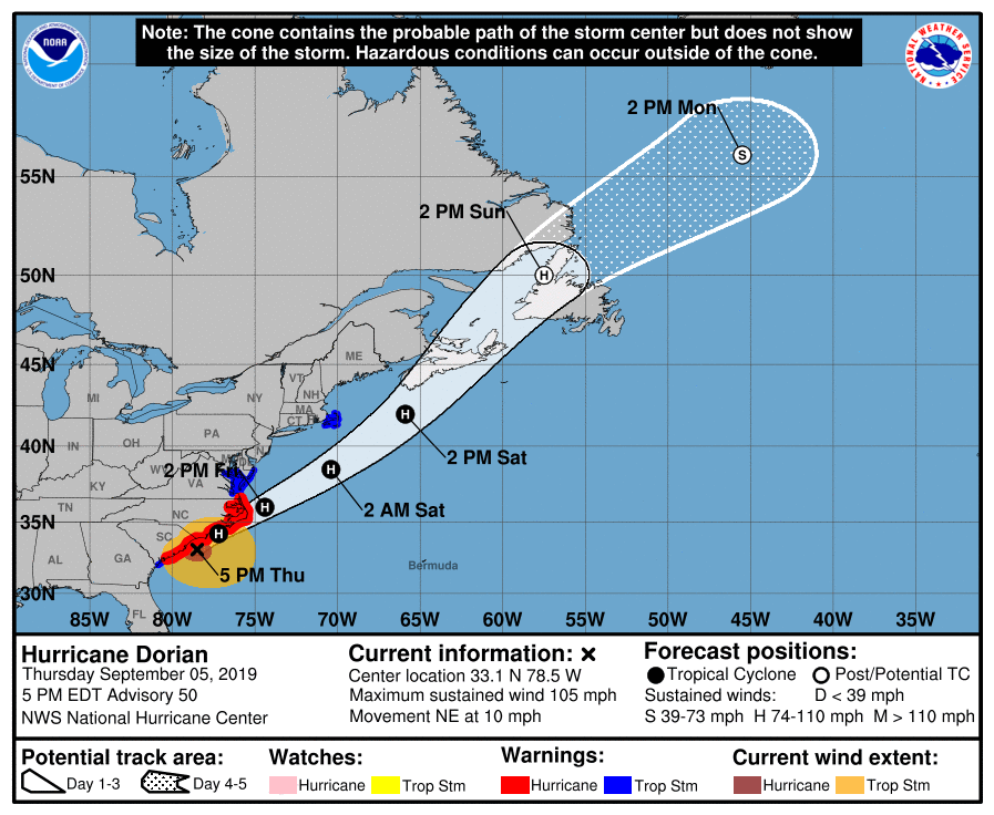
 I am writing about an area of disturbed weather over the central Bahamas which the national hurricane center has designated potential tropical cyclone number nine. It’s still lacks a closed circulation however the NHC is giving it a 70% chance of tropical development within the next 48 hours and an 80% chance within the next five days. If you look at the water vapor loop below you’ll notice that the upper level low which a few days ago was over the north east Bahamas has now looped over Georgia and has subsequently  moved south west and now is situated over the Gulf of Mexico and is slowly moving to the west. If it had remained over the Bahamas it would have to deflected the system through the Florida Straits however being in the Gulf of Mexico now it will tend to deflect the system further north. Notice on the surface map bottom diagram high pressure will be tending to steer the system to the east, what impact that upper level low has before it moves out of the area will be the main factor determining how far north the system gets. The NHC  Is currently forecasting it to become a tropical storm in the Vero Beach area. There is significant uncertainty in the forecast and will have to keep an eye on it. Due to significance shear it is unlikely to become a strong system.   But things can change. Note there is wide discrepancy in the computer models at this time with a few taking it across Florida into the Northeast Gulf of Mexico several making land fall on East Central Florida and an equal number of taking it out to sea missing the state altogether. Until it forms there is high speculation as to just where it will go.

I’ll keep a close eye on it.

Until  next time .  Matt.

Picture
Picture
Picture
Picture

Tropical updates 9-10-19, 8:30 am

9/10/2019

 
Good morning.

Just a quick post about a few areas in the tropics. In a nutshell, nothing to worry about at this time. High pressure over Florida, a strong upper level low over the NE Bahamas and high shear are currently protecting the state of Florida. The only one we'll have to watch is the one just off the coast of Africa which is still  10-14 d away, as conditions will likely change by the time it is anywhere near us.

Of note are the extremely warm sea surface temperatures in the Gulf of Mexico. It is a potential bomb. Something is likely to happen there before the end of the season, unless some cold fronts can cool it off.

​Until later,   Matt. 
Picture
Picture
Picture
Picture
Picture
Picture

tropical Update friday 9-6-19, 4 pm

9/6/2019

 
Good afternoon.

At 4 pm Hurricane Dorian was moving out to sea with peak winds of 90 mph. Last night and this am Dorian brought Cat 1 conditions to coastal North Carolina from Wilmington to Cape Hatteras with peak sustained winds recorded on land (reported so far in Hatteras) of 77 mph with gust to 89 mph.
Fortunately it remained approximately 70 miles off the Florida coast and Florida only experienced minimal tropical storm conditions. (See Wind Field Analysis below.)

Unfortunately Dorian was a life changing and history changing event for those with in its eye wall in Great Abaco and Grand Bahama. When it made landfall the eye was 10 miles wide and the eye wall only 2-3 miles thick. Unbelievably many areas remained 12-20 hours within that 15 mile wide zone of destruction. It was unprecedented and hopefully we'll never see anything like it again. It will likely take decades for them to really recover. 

I hopefully will not need to write further about Dorian.

Until next time,              Matt.

Picture

tropical update friday 9-6-19, 8 am

9/6/2019

 
Good morning.

At 8 am Dorian was clipping the Outer Banks with the eye currently right over Cape Hatteras. See radar below. Peak winds so far have been in the 70s due to a forward of 14 mph. It will be moving out to sea over then next couple of hours and will lead to storm conditions over Nova Scotia and Newfoundland over the weekend.

Elsewhere there is a wave which came off of Africa on Wednesday, the one I'd spoken about over a week ago which we'll need to watch. Fortunately we have blocking high pressure to our east. Unless it should get south of Cuba, we should be okay with that one.

Until next time,                Matt.

Picture
Picture

Tropical update thursday 9-5-19, 7 pm

9/5/2019

 
Good evening.

 At 5 PM Dorian was moving north east at 10 miles an hour. The forecast for Dorian has not changed since yesterday. Dorian brought tropical storm conditions to South Carolina today and it looks like it will pass and close enough to the North Carolina coast for hurricane conditions to exist from Wilmington through the Outer Banks.  With a forward speed of 10 miles an hour the peak wind should be in the 90s. 
Picture
Picture

tropical update wednesday 9-4-19, 3:30 pm

9/4/2019

 
Good afternoon.

Below I've attached several graphics. First the latest NHC's track which is in line with the current model consensus. Next SE US live radar, then live satellite feed, then the current water vapor loop and lastly the current Surface Map. They are all of the same area and yet all differ in the information that they provide. On the radar you can clearly see Dorian's eye which has now expanded to 60 miles wide. In the satellite loop you can see how the eye is becoming better defined, in the Water Vapor loop you can best see the motion of the atmosphere that surrounds it. Due to the SE flow on the east side of the storm the frontal boundary to its north has become indented. If you look at the last diagram you can see where Dorian is headed. If you look at the isobar to the NE of Dorian you can see where it intersects with the coast just west of the Outer Banks. This is the center of its current track. Coastal North Carolina from Wilmington east are presently at greatest risk.

A Different Animal. As opposed to the Dorian we saw 2 days ago, strong and compact, Dorian now is a much larger, though fortunately weaker system. Hurricane force winds now extend 50 miles NE of the center, strong storm force winds (50-70 mph) 80 miles and weak storm force winds (40s) 160 miles to the NE of the Center. The Carolinas are going to have a tropical storm and coastal North Carolina probably a hurricane. Peak winds are anticipated to be in the 90-100 mph range. *** Note as it will be moving in the opposite direction of the winds the peak winds (out of the NE) will be reduced by its forward speed, if it accelerates this could significantly decrease the impact. *** Due to the wide eye it is unlikely that it is going to be a total miss. This should be primarily a coastal event and hopefully the strongest winds will stay off shore with the exception of the Outer Banks which will likely get clipped.

After it starts it's NE move tomorrow we'll have a better idea as to where precisely it will likely go.

Until tomorrow,              Matt.

Picture
Picture
Picture
Picture
Picture

Tropical uddate tuesday 9-3-1, 6 pm

9/3/2019

 
 Good evening.

At 5 PM hurricane Dorian was finally moving north west at 6 miles an hour. The current NHC track is below. Dorian is moving well off shore of Florida and only mild tropical storm conditions are anticipated with peak winds in the 30s to 40s for the state. Dorian remains a potential threat to the Outer Banks but it’s still too early to say for sure. Elsewhere there are several new system  most notably is Fernand in the Gulf of Mexico which should move into Mexico tomorrow. Hopefully it will remove some of the built-up heat in the Gulf. None of the other systems pose a threat to the US at this time. 

 Until next time.

Matt .

Picture
Picture

Tropical update tuesday 9-3-19, 5 am

9/3/2019

 
Good morning.

At 5 am Dorian was located just north of Grand Bahama at 26.9° north 78.4° west and was stationary. The barometric pressure was 950 mbs and peak sustained winds were 120 mph. Of note is that Dorians coordinates are exactly the same as they were at 6 PM. During that time Dorian has been wobbling slightly in the same area with the southern eye wall moving on and off of Grand Bahama. The devastation after it pulls away will be extensive. I suspect that there will be near complete loss of all vegetation as well as extensive damage to many structures. Also of note is that Dorian is weakening. This is due to land interactions, the shallow waters north of Grand Bahama Island as well a possibly a component from a phenomenon known as upwelling. The northern portion of the eye is over deep water. When Dorian was a CAT 5 with winds of  185 mph it created a storm surge or wall of water moving in all directions approximately 20 feet high, with the winds of 120 mph the storm surge is probably in the range of 10 to 12 feet. This wall of water moving in all directions needs to be replaced. This occurs from the depths. Normally storm draw from the top 200 feet of the water column however when they are stationary over long periods of time water is drawn from much deeper. This very deep water is often much cooler than 80°. Especially in northern latitudes the phenomenon can be dramatic.


Dorian remains well east of the yesterday’s NHC’s projected track at this point in time and my track has not changed since yesterday evening. Note the NHC has now moved its track in line with mine. However until it begins it’s north west and north move later today we won’t know for sure as furthers wobbles or drifts to the west could occur. I’ll be writing again later this evening, sooner if significant changes occur. 

Until next time,

Matt. 

Picture

Tropic update Monday 9-2-19, 6 pm

9/2/2019

 
Good evening.

 At 6 PM hurricane Dorian was located at 26.9° north and 78.4° west was stated to be stationary with a minimum pressure of 940 mbs and peak winds of 145 mph. If you look at the water vapor loop below which is current you’ll notice an interesting feature. Over the past hour Dorian has wobbled northward approximately 7 miles and the eye wall for the first time today has lifted off the island of Grand Bahama. Hopefully this trend will persist. Of note for the current latitude the NHC forecast had Dorian at 79.0 W.  It is 42 miles east of that now. The NHC‘s track has not changed since this morning and brings Dorian approximately 30-50 miles east of the Florida East Coast. In light of this deviation my current track brings Dorian approximately 70 miles east of the coast line. If this holds Florida would avoid hurricane conditions. It is still way too early to say and we will have to wait until Dorian begins it’s northwest and northern move tomorrow but I’m encouraged by its current position.

I’ll write again tomorrow morning .

Matt.

Picture

tropical Update, 9-2-19, 1:00 pm

9/2/2019

 
Good afternoon,

As promised, here is the latest wind swath forecast. As you can see, on its current track, Florida is not forecast to experience hurricane-force winds.

Until next time,
Matt
Picture
<<Previous
Forward>>

    Categories

    All
    Preseason Update