Matt on the Tropics
Tropical Updates
  • Home
  • About
  • Archive (pre-blog)
  • Contact
  • Weather Links
  • Weather Trivia

TRopical Update 8-15-18, 9 am

8/15/2018

 
Good morning.

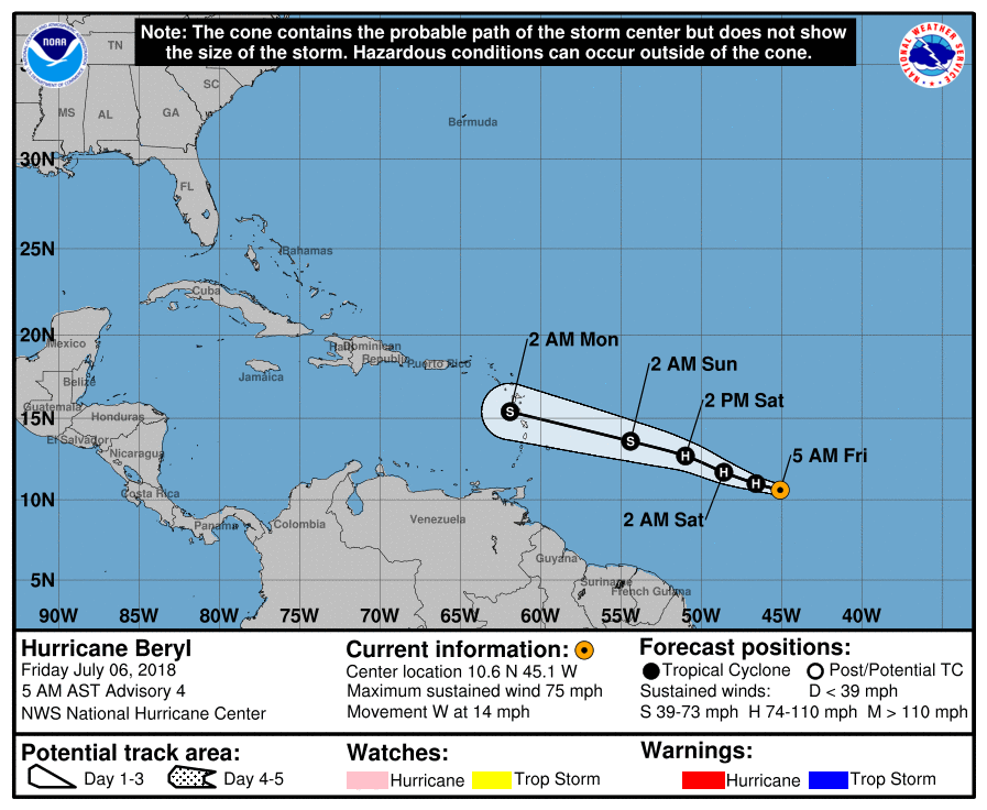
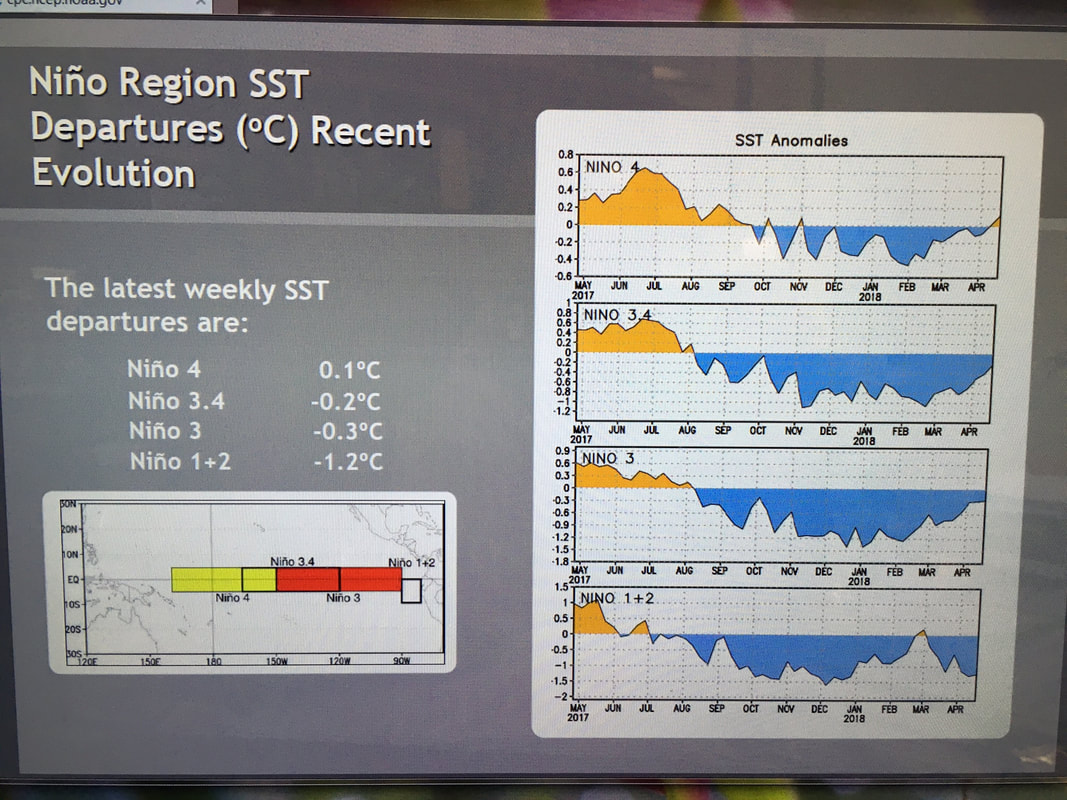
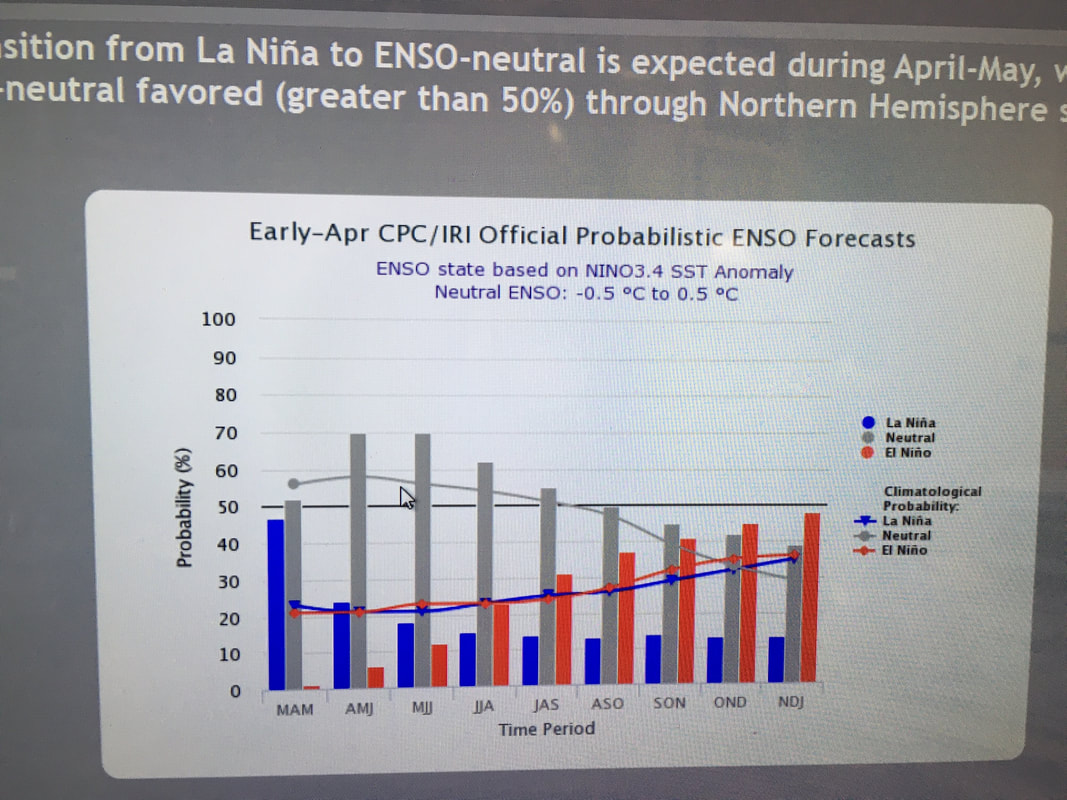
So far so good. The tropics have remained quiet so far however we are still early in the Hurricane Season. The NHC which had earlier in the year forecast an above average season is now in agreement with my Preseason forecast of 4/27/18 and is forecasting an average to below average season. Water temperatures remain below average in the eastern Atlantic which should lessen the number of Care Verde storms, which is good as they tend to be the strongest. However all it take is one.
South Florida appears to be at below average risk for this year.

Until later,

                                            Matt.


Tropical Update Friday 7-6-18, 7 am

7/6/2018

 
Good morning.

Tropical Storm Beryl formed yesterday and this am became the first Hurricane of the 2018 Atlantic Season. Beryl is a tiny storm with a 5 nm wide eye and a very small circulation as well. It is currently moving west across the southern tropical Atlantic. See NHC track below, first diagram. Beryl is expected to dissipate as it approaches the Lesser Antilles on Monday due to high shear as it approaches the Caribbean. It's small size will make it particularly vulnerable. High pressure over Florida, see bottom diagram, should keep it away from the state. My current track is south of the NHC's track and takes it toward northern Nicaragua, however it should not exist by that point in time. Unless things should change I do not anticipate the need to write much more about Beryl.

Have a great weekend,

                                                  Matt.


Picture
Picture

Tropical Update Tuesday 5-29-18, 7:30 AM

5/29/2018

 
Good morning.

Sub TS Alberto made landfall yesterday along the Florida Panhandle at Laguna Beach FL, just east of Pensacola. Alberto slowed and weaken prior to landfall. Peak wind gust recorded was 59 mph at Panama Beach FL. Its remnants are moving slowly inland, northward and will enhance rainfall over the South Atlantic States and the Mississippi watershed.

Elsewhere things are quiet and hopefully we won't have to deal with much for a while.

                                                                  Matt.

Tropical Update Sunday 5-27-18, 6 am Sub-TS Alberto

5/27/2018

 
Good morning.

At 5 am Sub Tropical storm Alberto was located at 25.0 N and 84.2 W and was moving NNE @ 13 mph with peak winds of 40 mph. Alberto remains in a high shear environment as it moves around the periphery of an upper level low in the central Gulf of Mexico. Alberto continues to move toward the Florida Panhandle and the NHC is now in agreement on this. Of note is that a mid level center of circulation has formed to the NE of the low level center which if it should dominate could shift the models a little further east. Alberto is currently about 270 miles due west of Miami and SE Florida should receive most of its rainfall today. The NHC is currently forcasting Alberto to transition to a Tropical Storm today and have peak winds of 60 mph when it makes landfall along the Florida Panhandle tomorrow. Storm force winds currently extend about 100 miles to the SE and 130 mile to the NE of the center. No storm force winds were noted on the west side of the system due to shear. A Hurricane Hunter aircraft will be investigating the storm this morning and we should get more details. Most importantly about the 2 competing centers of circulation.

Overall not much has changed with Alberto.

Florida should prepare for a wet day today.

My best to all,                     Matt.


PS. I am unfortunately unable to post graphics today as I am out of town and the computer in my hotel won't allow me to copy images.

Tropical Update Friday 5-25-18, 1 pm TS Alberto

5/25/2018

 
Good afternoon.

Sub-TS Alberto formed this am and at 10 am was moving NNE @ 6 mph with 40 mph peak winds. Alberto is undergoing significant shear as discussed in my 5-23-18 update, in fact that entire forecast still holds. It is currently headed for the northern Gulf Coast. My current estimate would be for landfall Monday along the Florida Panhandle near Pensacola however strengthening high pressure over the Atlantic late in the forecast period could lead to a shift to the west toward Alabama, Mississippi or  Louisiana. I currently do not expect much more than a rainy Memorial Day Weekend for Southeast Florida, (what else is new).

Have a great weekend and try to stay dry.

I'll write further if things should change.

Matt.

Picture
Picture

Tropical Update Wednesday 5-23-18, 09:30

5/23/2018

 
Good morning.

I am writing about an area of disturbed weather just east of the Yucatan Peninsula. The NHC is currently giving it a 60% chance for tropical development over the next 5 days. It is currently undergoing significant shear and development if any should be slow to occur as it slowly drifts northward. Due to the shear even if it should develop it is unlikely to become more than a tropical storm until it reaches the extreme northern Gulf of Mexico where shear will lessen. (See bottom diagram, Wind Shear Analysis, everything in Red is Unfavorable for development). Currently the northern Gulf coast appears to be at greatest risk, (see middle diagram, Surface Map, for upper level steering forces). Due to high SW shear, if it passes to our west, as forecast, we should see enhanced rainfall from it over the weekend as most of its associated weather will be on the east side of the system. I am not overly concerned at present though anticipate a wet Memorial Day weekend for South Florida.

I will update you as things develop, or not.

Matt.

Picture
Picture
Picture

Preseason Tropical Update 2018

4/27/2018

 
Good morning.

I have been following conditions in the Atlantic and Pacific for the past few months and it is starting to look more likely that an El Nino may form by the end of the year. We currently have La Nina conditions, why we had above normal activity last year, however they will probably end in June with neutral ENSO conditions for the summer with an El Nino starting between September and January. If it starts in November or December it should have little impact on the 2018 Tropical Season, however if it starts in September or October it could lead to reduced activity late in the season.

Currently we have reduced shear, related to the La Nina, below average water temperatures in the Eastern Atlantic and above average temperatures in the Gulf of Mexico and the Western Atlantic. This pattern would favor storms in the Gulf of Mexico and the Western Atlantic putting the northern Gulf Coast and the Carolinas at greater risk this year.

I currently anticipate an average Hurricane season for the Atlantic. If an El Nino develops early enough we may see some reduction in late storms. With the currently favorable conditions the possibility of late May or June storms would be greater.

On average we see 12 named storms, 6-7 hurricanes with 3 major in the Atlantic Basin each year with an approximate 14% chance of hurricane conditions being observed in Miami-Dade County.

Below are charts of, first, water temperatures in the Pacific, blue are below average, yellow are above average. La Nina is >3 months of temperatures < 0.5 degrees below average, El Nino > 3 months with water temperature > 0.5 degrees above average. Notice we are currently in the blue however temperatures are rising.
Second is the probability of La Nina, Neutral ENSO or El Nino conditions. Notice by October, November, December El Nino condition are more likely than La Nina or Neutral Enso conditions and that the probability curve is rising.

Hoping for a quiet tropical season in South Florida however remember how busy a season over all is not what counts. Its weather you get a storm or not and that is dependent on the specific conditions that exist at the time it is out there. And that is not something that anyone can predict at this time.

My best to all,                       Matt.


PS. For those new to the site I recommend viewing 3 things in the Archive Section to give you a better feel for what I do, and how I differ from anyone else. Please read my Perspective from 2005, as well as my forecasts for Ivan and Katrina.


Picture
Picture

2017 Tropical Season Recap, as of 11-15-17

11/15/2017

 
                                                         Tropical Season Recap 2017
 
2017 was a busy year in the tropics. The anticipated late season El Nino did not materialize, which combined with above average water temperatures and less than expected shear in the Caribbean and Atlantic lead to an increase in the number and intensity of storms in 2017.

For the US;

Tropical Storm Cindy made landfall near the Texas-Louisiana border bringing heavy rain.

Hurricane Harvey impacted coastal and inland Texas with record rainfall including the highest US storm total ever with 52 “ of rain recorded in the Houston area.

Hurricane Irma brushed NE Puerto Rico and then hit the Northern Coast of Cuba, the Lower Florida Keys, Marco Island and the Naples area with Cat 3-4 conditions. The entire state of Florida experienced tropical storm conditions with a prolonged weather event with 30 hour of storm conditions in Miami-Dade County. That combined with almost 8” of rain lead to numerous downed trees.

Hurricane Marie crossed the entire length of the island of Puerto Rico as a strong Cat 4 storm with 150 mph winds. Power is still out there.

Hurricane Nate made landfall in coastal Mississippi as a strong tropical storm.

And “Potential Tropical Storm” Philippe crossed over the Upper Florida Keys and extreme SE Florida with gusts to 29 mph.

Picture
Picture

Tropical Update Monday 10-30-17, 8 am

10/30/2017

 
Good morning.

“Potential Tropical Storm Philippe” officially dissipated yesterday though I’m not sure it ever existed. It supposedly passed right over us early Sunday morning though peak winds in Miami were 24 with gusts to 29. Peak wind gust in Nassau was 32 mph. It had multiple centers though none were visible on radar Saturday. The airport received 1.33” of rain though I recorded 4.01” at my house for the weekend. The rain which we received came from a different, non tropical,  low pressure center off shore of Naples which developed along the tail end of the cold front which passed through  Florida yesterday. The only significant weather was from a couple of small tornados which formed in our area.
Elsewhere in the tropics things remain quiet and hopefully we won’t see anything else this season.
 
Until next time,
                                            Matt.

Tropical Update SATURDAY 10/28/17, 8:30 AM

10/28/2017

 
Picture
Good morning.

A broad area of disturbed weather this morning over the northwest Caribbean Sea is moving generally northward. The National Hurricane Center has called it "Potential Tropical Cyclone 18." Hurricane hunters yesterday found no defined center of circulation. There is currently high shear north of it and over Florida. This should prevent any significant development.

It should enhance shower activity later today and tonight, however I do not anticipate any significant wind for South Florida. Due to high shear out of the southwest, any significant weather should remain well to our east. The Bahamas may experience winds near tropical storm force. South Florida may have winds in the 20s to low 30s. The main weather we may experience will occur between 7 pm tonight and 7 am tomorrow.

This should not be a significant weather event for South Florida. We MAY get 1-2 inches of rain.

Until next time,
​Matt
Picture
<<Previous
Forward>>

    Categories

    All
    Preseason Update