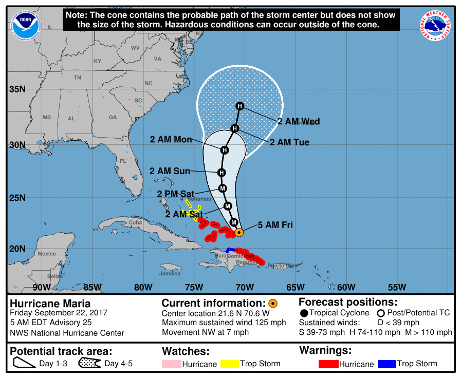
Matt on the Tropics
Tropical Updates
  • Home
  • About
  • Archive (pre-blog)
  • Contact
  • Weather Links
  • Weather Trivia

TRopical update Monday 10-9-17, 3 pm

10/9/2017

 
Good afternoon.

Tropical Storm Ophelia has formed in the Central Atlantic, however it poses no threat to land.

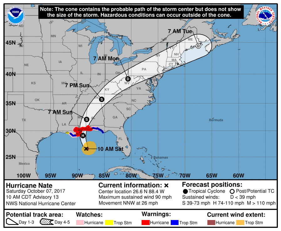
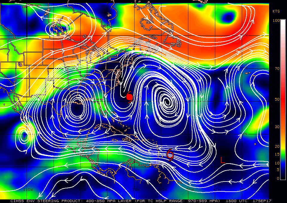
Elsewhere the remnants of Nate are over Pennsylvania and not doing much. Nate made landfall on Saturday night, 10-7-17, per the NHC as a minimal Cat. 1 hurricane, however no hurricane force winds were recorded on land and it may be retrospectively downgraded to a tropical storm. About 12 hours prior to landfall the shear caught up with it and for the last 6 hours prior to landfall radar showed a poorly formed storm with only the northern and eastern eye walls visible.

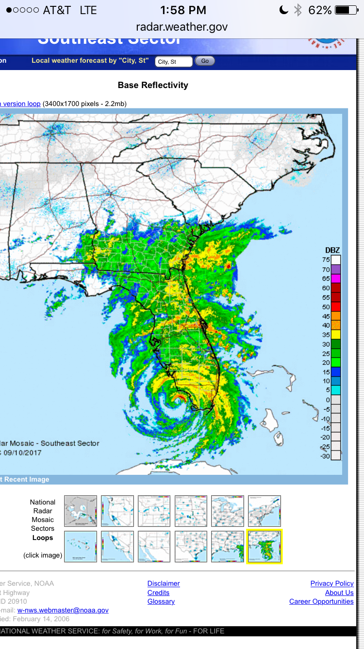
It made 2 landfalls. First over the marshes near the mouth of the Mississippi River and second along the central Mississippi coast near Biloxi. Peak winds were a gust of 74 mph near the mouth of the Mississippi River and a gust of 73 mph in Gulfport MS with peak sustained winds there of 51 mph. Peak winds in Biloxi were sustained of 35 mph with a peak gust of 52 mph. Its greatest impact was its associated 3-6' storm surge which fortunately receded quickly due to its rapid northern motion.

Until next time,                                      Matt.

tropical update saturday 10-7-17, 1 pm

10/7/2017

 
Picture
Good afternoon.

At 11 am Hurricane Nate was located at 26.6 N & 88.4 W and was moving NNW @26 mph with peak winds of 90 mph. Nate should make landfall tonight along the Mississippi coast. Due to its rapid northern motion its effective net shear has decreased ( upper level winds out of S at around 40 mph less forward speed of 26 = net shear <15 mph) which along with it missing the Yucatan Peninsula has lead to its strengthening. Nate may be a Cat 2 storm at landfall. Fortunately Nate is a small storm with Hurricane force winds extending only 30 miles on the east side of the storm, No hurricane force winds were found on the W side of the storm, due to shear and its rapid forward motion. This should spare New Orleans from hurricane conditions. After landfall it will move rapidly off to the N and NE and weaken quickly.

Until next time,                                           Matt. 

Tropical Update Thursday 10-5-17, 1 pm

10/5/2017

 
Picture
Good afternoon.

Tropical Storm Nate formed this am and at 11 am was located right along the NE coast of Nicaragua. and was moving NW @ 9 mph. Nate is moving into a weakness in the high pressure ridge to its north toward the northern coast of the Gulf of Mexico. Once it enters the Gulf of Mexico it will encounter significant shear and it is unlikey to be more than a Cat 1 storm at landfall, possibly just a tropical storm. The Global Models span from Louisiana to Alabama at this time.  Nate currently does NOT pose a threat to South Florida. We should know more specifically where its headed on Saturday am.

Until next time,                  Matt.

Picture

tropical update Friday 9-29-17, 7 am

9/29/2017

 
Picture
Good morning.

I am writing about an area of disturbed weather over South Florida, The Florida Straits, Cuba and the NW Caribbean Sea, see image above. The NHC is expecting an area of weak low pressure to form today over the Florida Straits and for it to drift northward right along the east coast of Florida over the next several days. They are currently giving it a 40% chance of tropical development over the next 5 days. Conditions are conducive for development over the next couple of days however by Sunday shear will increase and if nothing forms by then it will become less likely.
Looking at Key West radar this am there is no circulation in this area currently and development if any should be slow to occur. Showers are currently moving out of the SSE with a lot of associated tropical moisture. I anticipate a lot of showers over the next 4-5 days but probably not much more for South Florida.
I'll let you know if things should change but I am not overly concerned at present.

Elsewhere Maria and Lee are moving off to the ENE away from the US and may even Fujiwhara, see Weather Trivia Section on this site under "MORE". Not much else is out there. Tropical Africa remains quiet and I anticipate that the Cape Verde Season is over or nearly done for the year. In October the areas which we'll need to watch are the NW Caribbean and the Gulf of Mexico.

Have a great weekend, and have an umbrella or raincoat handy.

Until next time,                                               Matt.


tropical update Friday 9-22-17, 7 am

9/22/2017

 
Picture
Good morning.

At 5 am Hurricane Maria was located just east of Grand Turk Island. It is moving NW and tomorrow it should start to turn toward the N and then NE, see NHC forecast track above. High pressure over Florida should keep it away from the state, see Water Vapor Loop below. It is currently starting to encounter significant shear, see Wind Shear Analysis, bottom diagram - everything red is unfavorable for development. Pressures are  rising and it is starting to weaken. This trend should continue. Notice how its signature on the Water Vapor Loop is becoming less impressive and lopsided.

Unless things change I may not write further about Maria.

Elsewhere all is quiet on the eastern front.

Until next time,                                         Matt.

Picture
Picture

Tropical update Wednesday 9-20-17, 7 am

9/20/2017

 
Picture
Good morning.

At 7 am Hurricane Maria was located over the extreme SE coast of Puerto Rico. At 11 pm Maria was moving NW towards the extreme eastern tip of Puerto Rico with a 5 nm wide eye and its eye wall was about 25 miles wide and peak winds were 175 mph. On that trajectory it would have just brushed the extreme eastern portion of Puerto Rico. However, at around 2-3 am it underwent an eye wall replacement cycle with expansion of the eye to 30 miles wide associated with weakening of peak winds to 155 mph. At around 4-5 am it took a decided westward wobble (see Satellite Loop below) which brought it to just offshore of the SE coast of Puerto Rico. The subsequent expanded eyewall now spans approximately 50 miles and Puerto Rico is currently receiving a direct hit. Due to land interactions it is weakening and peak winds are probably around 140 mph currently. This will be a major hurricane for a large portion of Puerto Rico. Hopefully its mountainous terrain will defect the worst of its winds over a lot of structures however the damage will be extensive.

The NHC's and my track once north of Puerto Rico have not changed and it should pass well to the east of Florida. The remnants of Lee may regenerate however they do not pose a threat to land at this time.

The bottom radar image is of Puerto Rico at 06:20 EDT just before Puerto Rican radar went out. Maria appeared to be undergoing another eye wall replacement cycle with shrinkage of her eye, however with crossing land it will probably re-expand to 30 miles soon.

Wishing my best for our friends in Puerto Rico,

                                                                        Matt.

Picture
Picture

tropical update Tuesday 9-19-17. 7 am

9/19/2017

 
Picture
Good morning.

At 5 am Hurricane Maria was located at 16.0 N and 62.3 W and was moving WNW (300 degrees) @ 9 mph. In looking at the Surface Map and the Water Vapor Loop below you can see Maria moving along the periphery of the high pressure ridge to its north. It is currently headed toward the extreme eastern tip of Puerto Rico. It should pass just offshore of it and the NE Coast of Puerto Rico tomorrow.  It is going to be a close call for the extreme Eastern and NE parts of Puerto Rico. Maria is a very compact storm at present. The eye is 10 miles across and hurricane force winds only extend 20-25 miles from the center. To get major hurricane force winds the center would need to pass within 20 miles of you. A wobble either east or west could make a big difference. We'll probably have a better idea of just what they can expect early tomorrow am.

After it passes Puerto Rico it should turn to the NW and N and pass well east of Florida and most of the Bahamas. High pressure and dry air remain over Florida.

Elsewhere Lee is fizzing out being shorn by an upper level low to its NW, see Water Vapor Loop below. Not much else is out there at present. Even Tropical Africa is quiet.

Until next time,                                          Matt.

Picture
Picture
Picture
Picture

Tropical update Sunday 9-17-17, 3 pm

9/17/2017

 
Picture
Good evening.

On the satellite image above you can see Hurricane Jose, TS Maria and TD Lee. Jose should move NE and pass off shore of Cape Cod and Nova Scotia. Hopefully far enough away that they avoid any significant weather. Maria is forecast to strengthen and may threaten the Virgin Islands and Puerto Rico, see NHC forecast map below. Due to dry air and high pressure over the Gulf of Mexico, moving over Florida (see Water Vapor Loop below) Maria should stay east of Florida. The computer models, bottom diagram, also reflect this. Lee is currently very weak and may dissipate, however it too should pass well east of Florida. There is a wave over Africa which will emerge off the coast in about a week that we'll need to watch.

Hoping for a quiet rest of the season !!!

                                                                                Matt.
Picture
Picture
Picture
Picture

tropical update WEdnesday, 9-13-17, 8 am

9/13/2017

 
Picture
Good morning.

At 5 am Hurricane Jose was located at 26.1 N and 66.0 W and was moving SE @ 8 mph. Jose has weakened and should make a small loop and then turn NE out to sea. It remains primarily a threat to Bermuda however it will probably miss them as well. Unless things change I do not anticipate the need to write further about him.

Elsewhere there is not much else out there, fortunately !

Irma has caused extensive damage across the entire state of Florida with the worst damage in the Florida Keys. It will take a very long time for them to recover. I wish our friends on Big Pine Key my best.

Until the next time,                                           Matt.

Picture
Picture
Above is SE US radar of Irma just prior to second Florida landfall on Marco Island / Naples.

tropical update 9-11-17, 6 am

9/11/2017

 
​Good morning. 


At 5 am Irma was located at 28.9 N & 82.6 W and was moving NNW @ 18 mph with peak winds of 75 mph. Irma is expected to move NW into SW Georgia, Alabama and Tennessee over then next couple of days and dissipate. Irma was an expansive storm and with its more easterly move brought hurricane conditions yesterday to a large part of Florida. It made landfalls on Cudjoe Key and Marco Island. Peak winds recorded were in mph,

MIA 99

N Perry Airport Ft Lauderdale 109

Coral Gables 90

Ft Myers 89

Marathon 88

Deerfield Bch 86

NWS office Miami 81

Tampa 78

Sebring 78

West Palm Bch Intl Airport 77

Ft Lauderdale Intl Airport 75

Marco Island 130

Naples 142

Clearwater Bch 96


Reports are still not in from some of the Lower Keys where the eye crossed. 


Total storm rainfall accumulation at my house in Miami was 8.76". There is extensive tree damage however most structures in my area look good. 


Elsewhere Jose is weakening and is expected to meander for a while. We'll need to reassess him in a few days. 


Until later,              Matt. 


Sent from my iPhone
<<Previous
Forward>>

    Categories

    All
    Preseason Update