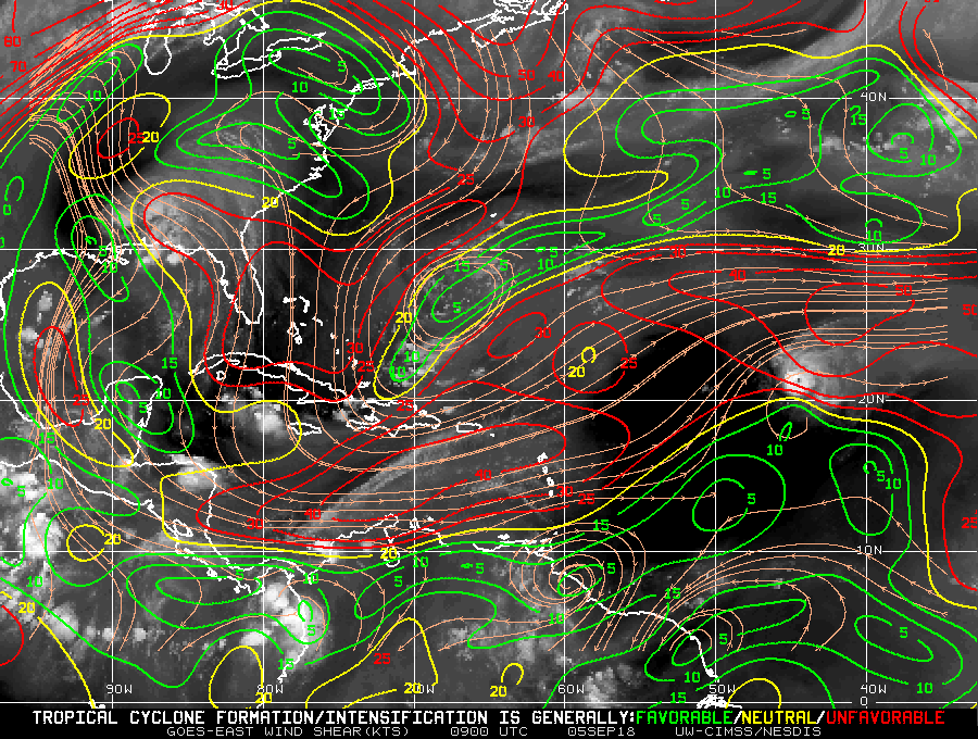
Matt on the Tropics
Tropical Updates
  • Home
  • About
  • Archive (pre-blog)
  • Contact
  • Weather Links
  • Weather Trivia

Tropical update Monday, 9-10-18, 9:30 am

9/10/2018

 
Good morning.

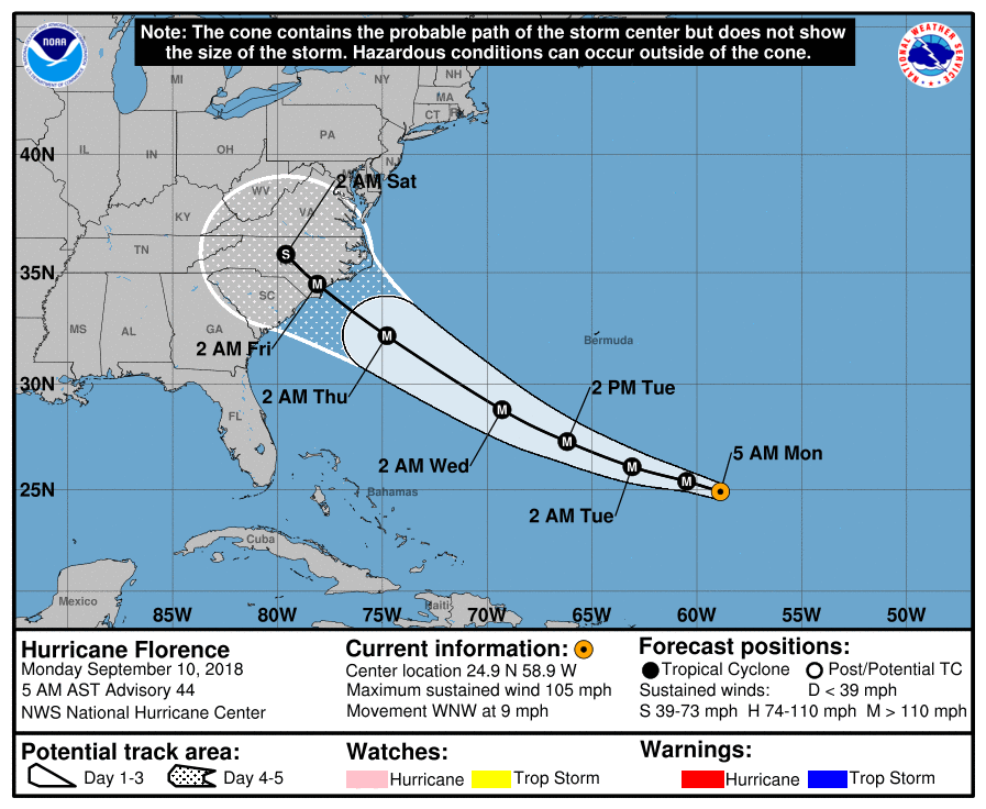
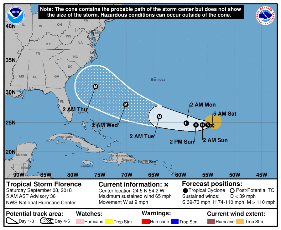
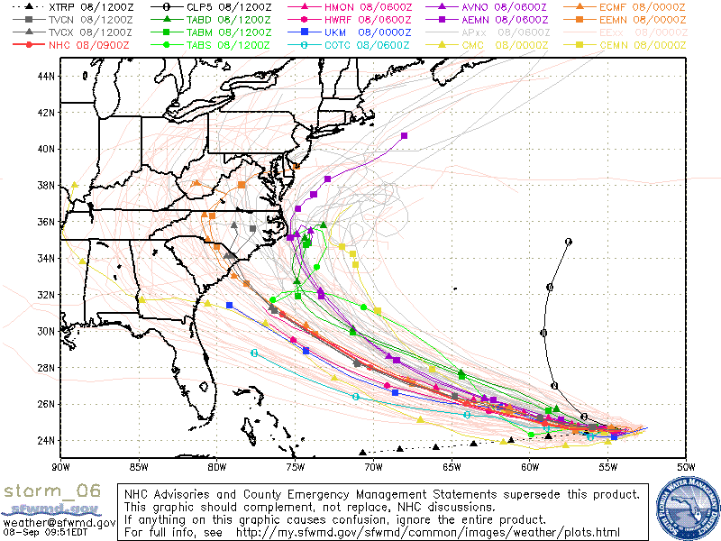
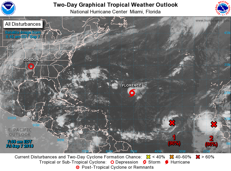
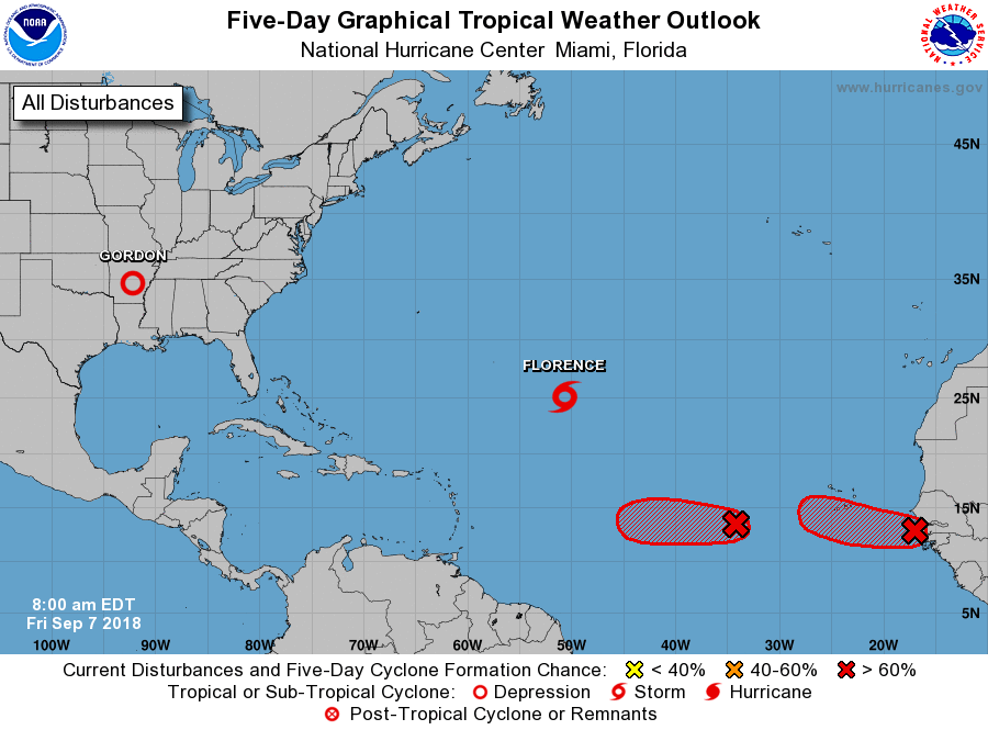
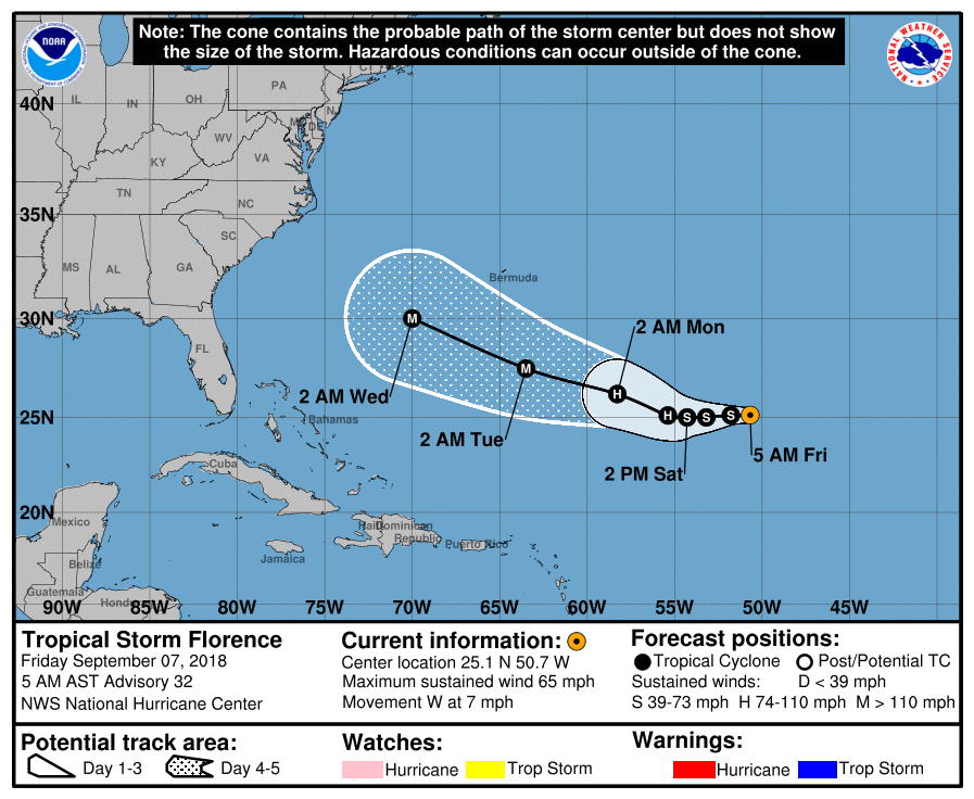
In reviewing the data this morning on Florence it is looking less likely that it will not make landfall. The NHC anticipates it to speed up which it is starting to do and make landfall before the approaching cold front from the west can deflect it out to sea. Of note the NHC is making a special trip today to evaluate the high pressure system over the Mid West that is driving the cold front. That information probably won't be factored into their forecast until this evening. We'll have to see. Of note is that Florence is south of where they had projected it to be at this time on Saturday. This may lead to a shift in the track southward closer to the SC/NC border. There are still numerous variables in play  however the Carolinas need to prepare for a major, probable Cat 4 hurricane.
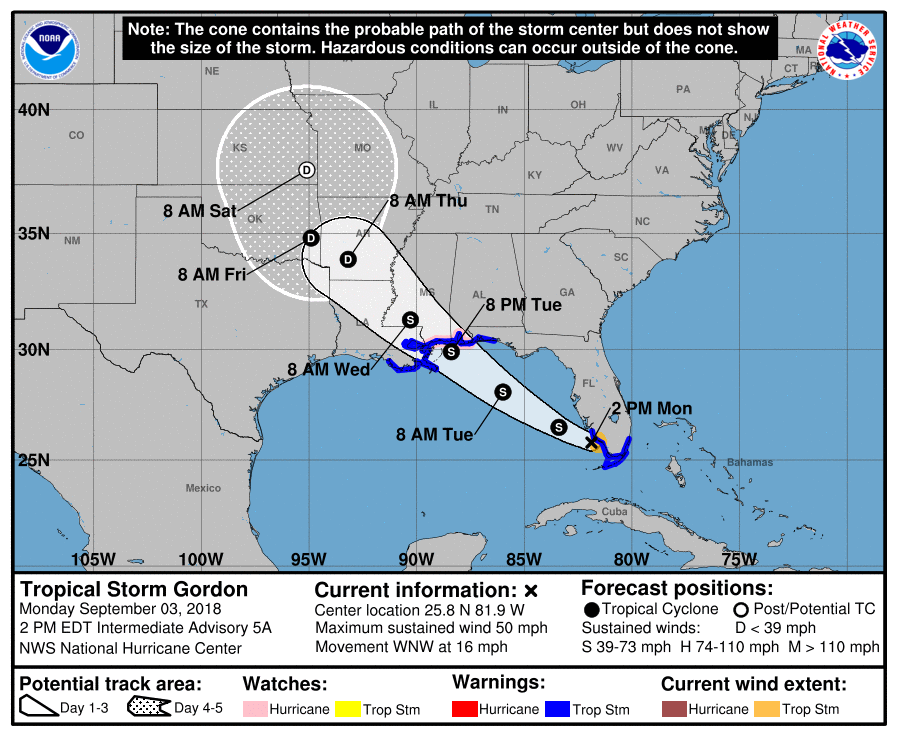
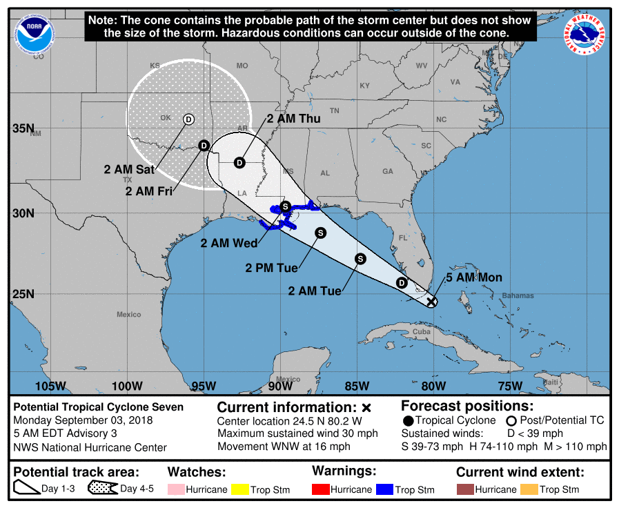
Due to the approaching front it is expected to slow down as it approaches the coast and they currently expect it to stall over land leading to potentially catastrophic flooding.

We'll have to see how things play out but it has the potential to be a devastating event.

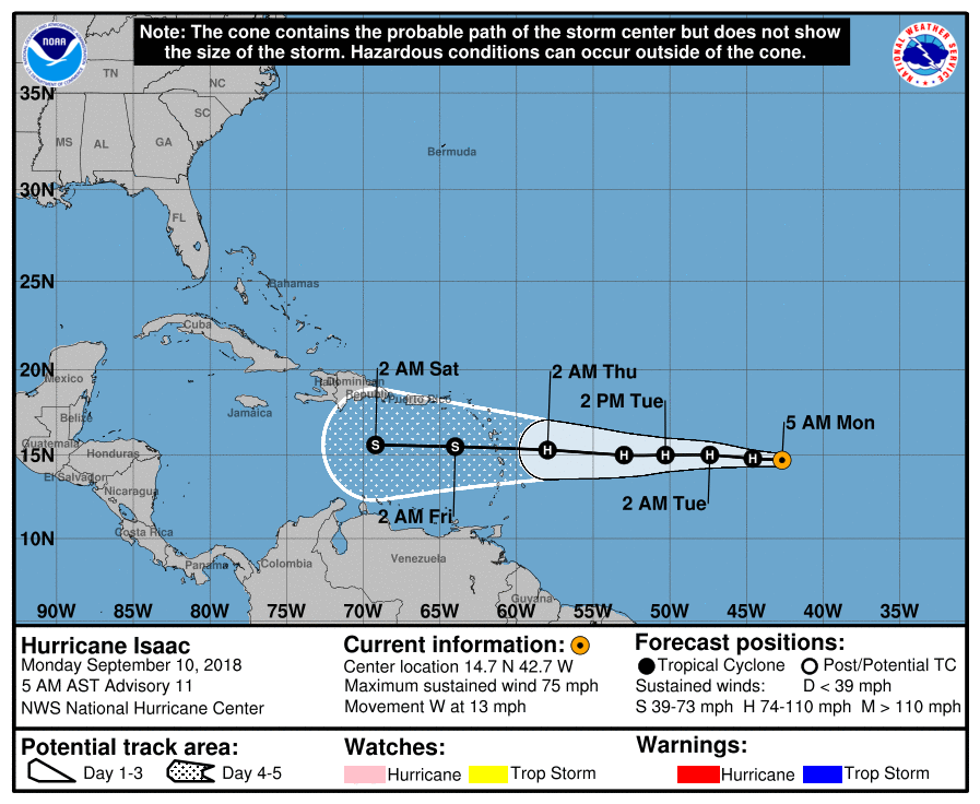
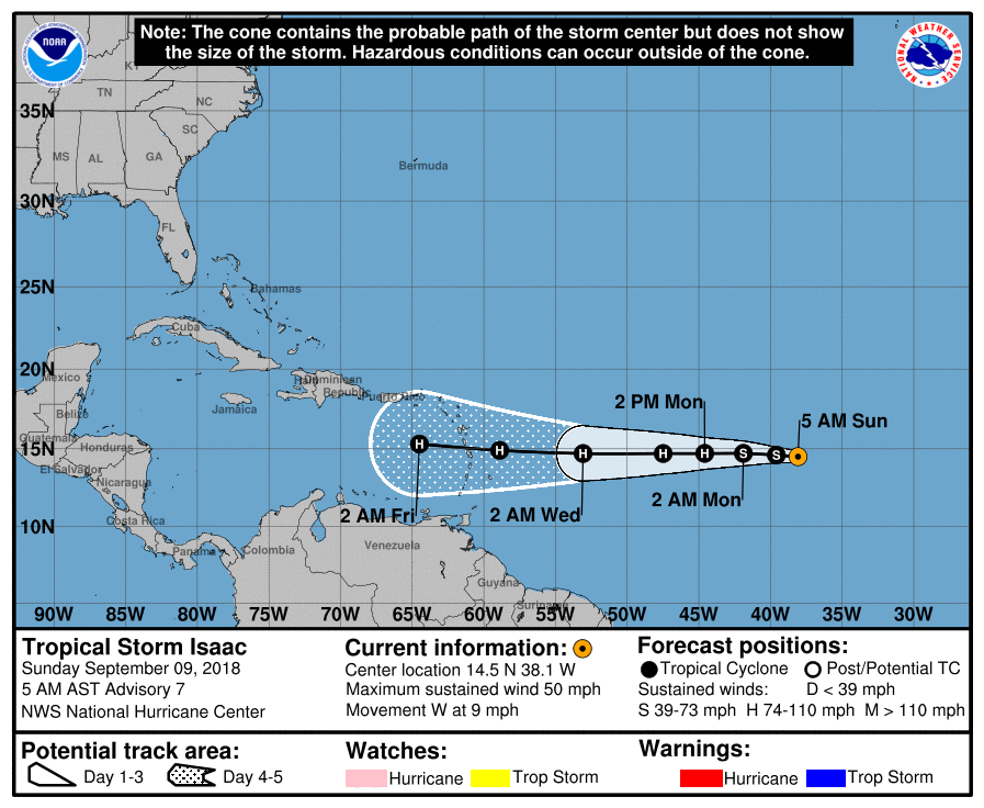
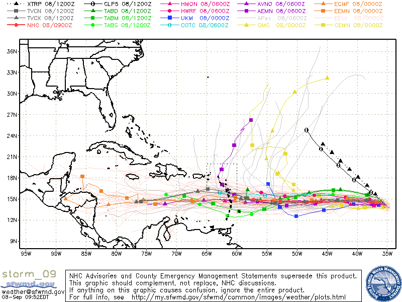
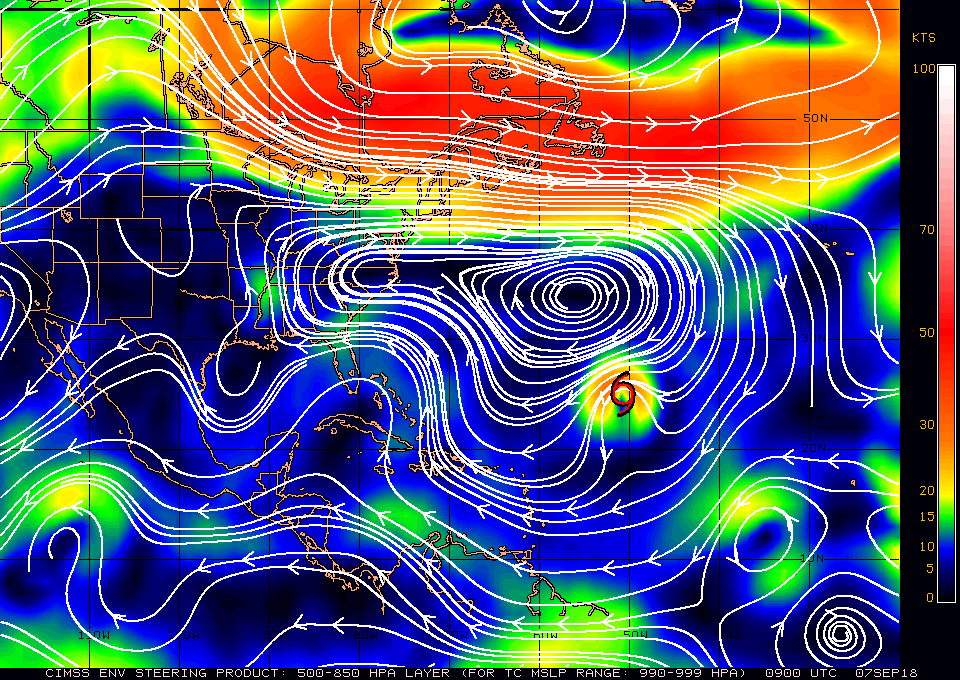
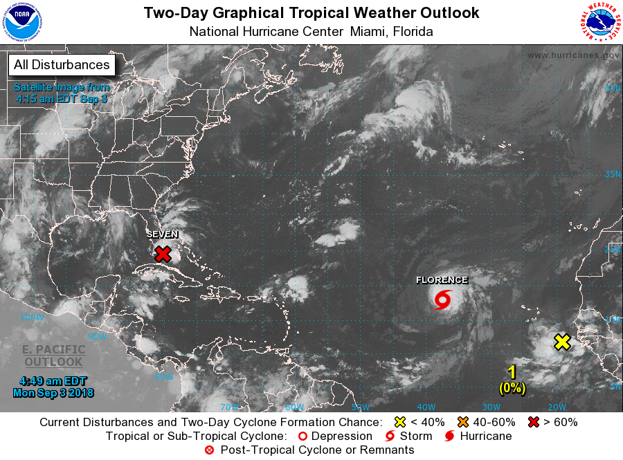
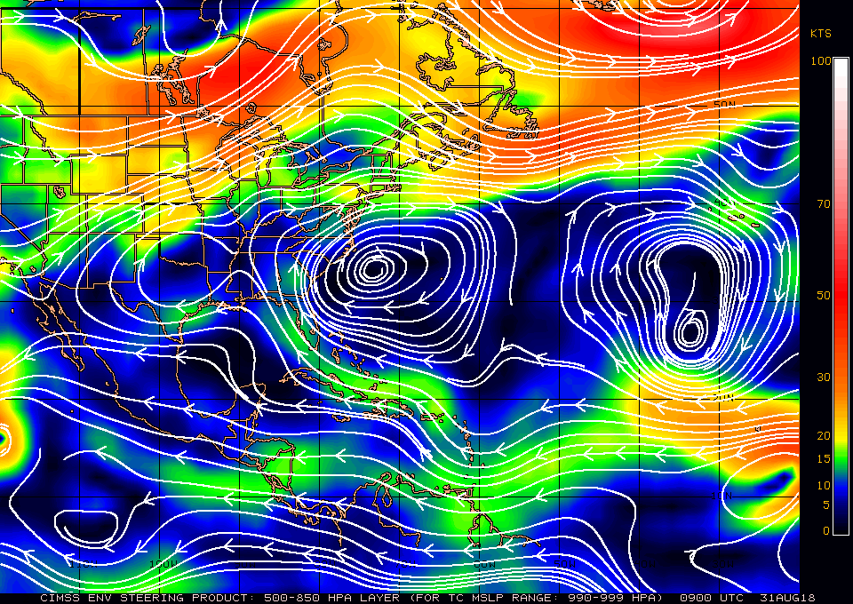
Isaac continues to move west. Note some of the models pull it north into the Atlantic, see bottom diagram. Time will tell.

Until next time,         Matt.


Picture
Picture
Picture
Picture

tropical update, sunday 9-9-18, 9 am

9/9/2018

 
Good morning.

Since yesterdays update little has changed with the NHC's projections though there are a few things of note.

First regarding TS Florence as anticipated the NHC has shifted the center of its track from South Carolina to North Carolina. Also note that Florence is moving very slowly. In general the slower the motion the more likely that things will change, thus the track. Notice the frontal system across the Central US in the first diagram. It is moving slowly eastward. This will hopefully be the "White Knight" to spare the Carolinas and the rest of the East Coast from Florence's eye wall.
My track for Florence has not changed from yesterday.

Isaac and Helene tracks so far have not changed from yesterday.

Elsewhere things are quiet.

Until later,             Matt.


Picture
Picture
Picture
Picture
Picture

Tropical Update Saturday 9-8-18, 9 am

9/8/2018

 
Good morning.

We have several area of interest this am.

First is TS Florence. Overnight it has been moving just south of W around the periphery of high pressure to its north. The NHC has shifted its track southward however this will probably be temporary. The Coastal Carolinas, particularly the Outer Banks of NC appear to be at risk. It is going to be a close call and they will need to prepare for possible major hurricane conditions. My suspicion is that it will turn away 20-50 miles off the coast but it will be too close to not be ready. Expect the models to continue to change. We'll just have to wait and see how things evolve.

Second is TS Helene, just off the coast of Africa. It is moving just north of W and the NHC is forecasting it to move WNW and eventually NW into the mid-Atlantic Trough. That would be great news for the US.

Third is TD #9, soon to become TS Isaac. This will become the one to watch. Fortunately it has numerous obstacles in front of it.  First is a lot of Saharan dust and dry air. (See SAL bottom diagram). It is in an area of modest shear, in a few days it will enter an area of low shear where it should strengthen however when it enters the Caribbean shear will increase significantly. (See Wind Shear Analysis below.) There is high shear currently over the entire Caribbean most likely thanks to a developing El Nino as discussed in my Preseason forecast in April. Building high pressure to its north should steer it into the Caribbean and hopefully south of Florida as well. It is still a long ways out and conditions as always will be changing. As long as storms are to our south we need to continue to watch them.

Elsewhere of note is that there are currently no other significant disturbances over Africa and it will likely be at least a week before we see anything else in the Eastern Atlantic.

Until tomorrow,

                                                        Matt.

Picture
Picture
Picture
Picture
Picture
Picture
Picture
Picture

Tropical Update Friday 9-7-18, 7:30 am

9/7/2018

 
Good morning.

Things are heating up in the tropics and there have been a few changes.

First, high pressure has built north of Florence and its route into the mid-Atlantic Trough has closed which will push it closer to the US. The current atmospheric conditions in the Atlantic are very complicated with numerous variable which are constantly changing. It has weakened significantly as discussed previously from a Cat 4 Hurricane to presently a tropical storm. However if you look at the wind shear analysis below you can see that it will be entering a lower shear environment in a couple of days and regeneration is likely. Fortunately it is still several day away from the US and at this time of year it is likely that a new frontal system will come in in time to prevent it from making a US landfall. The Carolinas to New England are still at risk but my gut feeling is that it will still miss the US.

Second the system labeled #1 on the 2 day map which I spoke about on 9-5 is very small and is approaching a high shear environment, being so small there is a chance that it may dissipate however if  it survives  it should pass north of the Lesser Antilles. It may pose a threat to the Carolinas however it hopefully will be deflected by a frontal system out to sea. We're just going to have to wait and watch this one.

Third, the system labeled #2, the one I've been writing about for several days, has just emerged off of the coast of Africa. It is the one I'm concerned about. As you can see it is a much larger system. I am encouraged that it has come off of the African coast at about 13 degrees, this is north of the sweet spot of 10-12 degrees which is the window that poses the greatest potential threats to South Florida and the Caribbean. The NHC is anticipating a WNW move which would be good, however with the dynamic atmosphere in front of it, it is just way too early to make an accurate prediction about it at this time. With its large size it has the potential to be a significant storm somewhere.

I'll probably write daily for a few days until things become clearer.

Until next time,
                                           Matt.

Picture
Picture
Picture
Picture
Picture
Picture

Tropical Update, Wednesday 9-5-18, 8 am

9/5/2018

 
Good morning.

Tropical Storm Gordon made landfall last night just west of the Alabama- Mississippi border as a strong tropical storm. A NOAA Coastal Marine Observing site on Dauphin Island, Alabama measured a sustained wind of 57 mph (91 kph) with a gust to 72 mph (117 kph) which have been the highest winds reported so far. The lowest minimum central pressure as estimated from NOAA Hurricane Hunter aircraft data was 997 MB (29.44 inches). Fortunately prior to landfall due to shear it lost its southern eye wall and it never made it to hurricane intensity.
I recorded 5.56" of rain at my house from Gordon, but fortunately we had no wind damage.

Elsewhere there are a few features of note.

First is Hurricane Florence in the Central Atlantic which is moving NW with 105 mph winds, it is entering an area of high shear and should start to weaken soon. (See Wind Shear Analysis, bottom diagram). Notice its well defined eye in the Saharan Air layer Analysis and the Wind Shear Analysis below. FYI that does not usually occur until hurricane force winds reach > or = 100 mph. It is entering the mid Atlantic trough as discussed previously and should miss the US.

Second is the orange X in the first diagram. This should track just south and west of Florence's track, being drawn towards the low pressure trough left in Florence's wake. It should also be drawn into
the mid-Atlantic Trough, and hopefully miss the US as well.

Third is the yellow circle in the second diagram. This disturbance is still over Africa and is the area I wrote about in my 9/3/18, 5:30 am forecast and will be the one to watch. Fortunately its a long ways out and there is still abundant Saharan Dust and high shear areas between it and us.
It has a lot of obstacles in its way, I'll be keeping an eye on it.

Until next time,                   Matt.


Picture
Picture
Picture
Picture

Tropical Update Monday, 9-3-18, 2:00 pm

9/3/2018

 
Good afternoon,

Tropical Storm Gordon formed this morning near Key Largo. It is currently located just off of Fort Myers. Gordon formed earlier and further north than the NHC had anticipated. In light of this, we'll probably see an eastern shift in its track and a more intense storm than initially forecast. I would not be surprised if it reaches hurricane strength. Fortunately, upper level shear prevented us from having any significant winds in South Florida, but we've had quite a bit of rainfall (approx. 5" at my house so far). 

I'll continue to keep an eye on Gordon as well as storms developing over Africa and the far eastern Atlantic.

My best to all,

                               Matt

Picture

Tropical Update Monday, 9-3-18, 5:30 am

9/3/2018

 
Good morning.

Since my last post the 2 disturbances discussed, Potential Tropical Cyclone 6 is now TS Florence and is headed toward the Central Atlantic and the area of disturbed weather north of Hispaniola is now centered 70 mile due south of Miami and is expected to become a tropical depression later today and a tropical storm late tonight or early tomorrow am. It is currently headed toward Eastern Louisiana and should make landfall just east of New Orleans as a tropical storm. Fortunately for them it has picked up speed and shouldn't have enough time to strengthen too much.

A new area of disturbed weather has recently moved off of the coast of Africa and is forecast to move WNW in a route similar to Florence. There is a wave over east-central Africa which we'll need to watch. It should emerge off the coast in about a week.

In the bottom diagram, Saharan Air Layer Analysis (SAL), you can see that the SAL persists over much of the tropical Atlantic and eastern Caribbean, however each wave will tend to slowly erode it as you can see Florence doing. (It has prevented Florence from intensifying.)

South Florida can expect a rainy day today as Potential Tropical Cyclone Seven passes to our south and south west. I do not anticipate much wind.

I'll keep you posted as things develop, or not,


                                      Matt.


Picture
Picture
Picture

Tropical Update Friday 7 AM, 8-31-18

8/31/2018

 
Good morning.

I'm writing about a couple of areas of disturbed weather in the tropics. Neither at this time appear to pose a significant threat to South Florida.

First is "Potential Tropical Cyclone 6" in the far eastern Atlantic. It is headed WNW and should get caught up in the  Mid Atlantic Trough and eventually move north posing no threat to the US.

Second is a tropical wave centered just north of Hispaniola. The NHC is giving it a 10% chance of development over the next 5 days. See Surface Map (second diagram), It should move along the periphery of high pressure to it's north through the Florida Straits into the Gulf of Mexico.
It is currently in a high shear environment, (see 3rd diagram Wind Shear Analysis, everything is red is unfavorable for development) however once it gets into the Gulf of Mexico shear lessens and development will be possible however it won't have a lot of time once it gets there; though water temperatures are warm.

I'll be keeping an eye on it and will write if things should change. South Florida will probably see an increase in shower activity late Sunday and Monday as the wave passes to our south.

Until next time,

                                                     Matt.


Picture
Picture
Picture

Tropical Update Wed. 8-29-18

8/29/2018

 
Picture
Picture
FYI an El Nino is probably coming. (Usually associated with decreased tropical activity due to a resultant increase in shear in the Caribbean and Southern Atlantic.)

Compare this bottom chart to the chart of 4/27/18 in Preseason Forecast. The timing will be the key. From looking at this it probably wouldn't start until October at the earliest, however shear is already high across the Caribbean and mid Atlantic, possibly related to rising Pacific Ocean sea surface temperatures?

Tropical Update Tuesday 8-28-18, 5 pm.

8/28/2018

 
Good afternoon.

FYI below average water temperatures in the Eastern Atlantic and abundant Saharan dust over the Eastern and Central Atlantic as well as the Eastern Caribbean continue to suppress tropical activity.

Below is the current Saharan Air Layer Analysis. (SAL)
Yellows, oranges and reds are Saharan dust which as it sinks through the atmosphere, suppresses convection. It is also associated with dry air.

So far so good, however above average water temperatures in the Gulf of Mexico and the Bahamas will make these areas to watch. See bottom chart of current sea surface temperatures (SSTs).

Matt.
Picture
Picture
<<Previous
Forward>>

    Categories

    All
    Preseason Update