Matt on the Tropics
Tropical Updates
  • Home
  • About
  • Archive (pre-blog)
  • Contact
  • Weather Links
  • Weather Trivia

Tropical Update Saturday 10-8-16, 8 am

10/8/2016

 
Good morning.

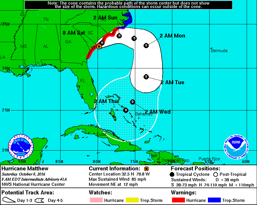
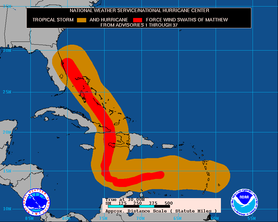
At 8 am Hurricane Matthew was located @ 32.5 N and 79.8 W and was moving NNE with peak winds of 85 mph. Earlier this am the center of its eye made its first US landfall along coastal South Carolina. In looking at radar this morning it is currently centered over Charleston, SC. The eye now measures 40 miles across which will expand the Hurricane force wind field. Heavy rains are affecting Georgia and South Carolina and will spread into Coastal North Carolina later today. The extent of Matthew effects have been remarkable and historic.

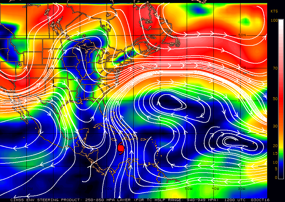
After tomorrow it will move out to sea and is expected to weaken significantly under heavy shear. We'll have to reassess around Tuesday to see what is left and whether we will have to deal with it again!

Until the next time,                                           Matt.

Picture
Picture

Tropical Update Friday 10-7-16, 7 am

10/7/2016

 
Good morning.

At 5 am Hurricane Matthew was located at 28.2 N & 80.0 W with a barometric pressure of 938 mbs and peak winds of 120 mph and was moving NNW @ 13 mph. It is currently about 25 miles offshore of the tip of Cape Canaveral and the western eye wall is just barely contacting the coast. Fortunately due to reasons noted in my 10/5/16 am forecast Matthew's actual track yesterday was about 30 miles east of the NHC's forecast track for yesterday morning. In light of this, as bad as things are and were yesterday, they would have been MUCH worse if Matthew had followed the forecast track.

From here Matthew is forecast to track parallel to the Florida coastline and then turn N and NE in response to a rapidly approaching front from the west. After that it may even loop back to re-threaten as a tropical storm??? (See forecast track below)

 Miami-Dade had minimal weather yesterday. Sometimes its just better to be lucky.

My best to all,                  Matt.

Picture
Hurricane Matthew Forecast track as of 5 am 10-7-16
Picture
Hurricane Matthew, Wind History as of 5 am 10-7-16

Update Hurricane Matthew Thursday 10-6-16, 5 am

10/6/2016

 
Good morning.

At 5 AM Hurricane Matthew was located @ 24.2 N & 77.1 W with a barometric pressure of 944 mbs and peak winds of 125 mph, moving NW at 12 mph. It is currently approaching Nassau as a Cat 3 Hurricane. Over night pressures have been dropping and it is expected to be a Cat 4 as it approaches the Palm Beach area tonight. The models are currently in good agreement with the forecast track below. Miami-Dade should still miss the heart of the storm and winds of 25-34 mph with gusts to 40-50 mph are forecast. Broward should see more as noted last night. It is still a compact storm with most of the weather on the eastern side of the storm. See forecast advisory below.

FORECAST VALID 06/1800Z 25.5N 78.4W MAX WIND 120 KT...GUSTS 145 KT.
64 KT... 35NE 30SE 25SW 30NW.
50 KT... 70NE 70SE 40SW 50NW.
34 KT...150NE 140SE 80SW 90NW.

Hurricane force winds only extend 30 miles to the west of the center, storm force winds, up to 90 miles. After it gets north of Miami it will start to cross the Gulf Stream and it should strengthen and the wind fields should expand.

If it follows the present track this would be a very severe storm from Palm Beach to Daytona with a significant storm surge. People in that area should leave coastal areas.

I wish we had better news for
Palm Beach north, I'll hope for a track slightly to the east a slight shift would make a huge difference. I have my fingers crossed.

Until later,    Matt.


Picture

Tropical Update Wednesday 10-5-16, 6 pm

10/5/2016

 
Good evening.

At 5 pm Hurricane Matthew was located over the southern Bahamas @ 22.5 N & 75.7 W and was moving NW @ 12 mph with a barometric pressure of 963 mbs and peak winds of 120 mph. Since 5 am this morning Matthew has been moving steadily just north of NW. This track is forecast to continue for 1-2 days after which time high pressure to its east over the Atlantic is expected to move eastward allowing Matthew to move N and then NE as a new front approaches from the west. The timing of that shift will be the key to just how much weather Central and North Florida receive.

The NWS is currently forecasting winds of 25-30 mph with gusts into the low 40s for Miami-Dade County. The forecast for Broward County is for peak winds of 45-55 mph with gusts to 75 mph.

Most of the associated weather should occur between 12 pm Thursday and 2 am Friday for Miami-Dade and  Broward Counties, lasting a bit longer for Broward.

I've attached the 72 hour Rainfall Projections below.


I'll write again early tomorrow am.

Hoping for no surprises,    Matt.
Picture
Picture
72 hour Rainfall Projections for Hurricane Matthew as of 5 pm 10-5-16

Tropical Update Wednesday 10-5-16, 5:30 am

10/5/2016

 
Good morning.

At 5 am Hurricane Matthew was located at 21.1 N and  74.6 W, moving N @ 10 mph with a barometric pressure of 962 mbs and peak winds of 125 mph. In looking at the data on Matthew this morning there are a couple of things of note. First is that it had slowed down and moved very little overnight and is currently located just north of the eastern tip of Cuba. Due to land interactions it has weakened and is currently a Cat. 3 storm. This however will be temporary and re-intensification is forecast after it gets away from Cuba. Unfortunately due to its slower movement the NHC's track has shifted slightly further to the west. Second, the front over north Florida has moved eastward and most of Florida currently has dry air over it. (This may be good news)
At 24 hours the NHC's forecasts tend to be very accurate. On its present track Miami-Dade County could see tropical storm conditions. Broward is on the edge of Hurricane conditions and Palm Beach County north could see Hurricane conditions. On its present track it would traverse a large portion of the Gulf Stream which is not good and a very intense Hurricane is possible. The hurricane force wind field is not very large however a minor shift in the track could bring Hurricane conditions on shore, or well off shore. Because it could be a close call we should all from Miami north prepare for Hurricane conditions; though frankly I don't expect them south of Palm Beach County.

The current forecast advisory when it is in our area ,
{ "
FORECAST VALID 06/1800Z 25.5N 78.2W MAX WIND 115 KT...GUSTS 140 KT.
64 KT... 50NE 40SE 30SW 50NW.
50 KT... 80NE 80SE 60SW 70NW.
34 KT...160NE 160SE 90SW 110NW. " }
only has storm force winds extending 110 mile to the NW of the center. On the current track it would pass 155 miles to the east of Miami. IF that happens Miami would only receive peak winds in the 30s.

My suspicion due to the movement of the front through most of Florida is that we will see a track slightly east of the present one. If you look at the models below, there are many that agree with me. However better safe than sorry.


I'll write further as things develop. On the present track strongest winds will be out of the NE and East, and after it passes, out of the north. Park cars close up on the west side of strong buildings. It should be at its closest approach tomorrow afternoon for Miami-Dade County. In Miami-Dade it should be primarily a coastal event. In general the further west and south you are the less weather you will receive.

Until later,                             Matt.


Picture
Picture
Hurricane Matthew Wind History as of 5 am 10-5-16
Picture
Models for Hurricane Matthew 5:36 am 10-5-16

Tropical Update Tuesday 10-4-16, 5 Pm

10/4/2016

 
Good evening.

At 5 pm Hurricane Matthew was located at 19.8 N and 74.3 W moving N @ 9 mph with a barometric pressure of 949 mbs and peak winds of 140 mph. The northern eye wall is currently making landfall along the very eastern tip of Cuba and should just barely  graze the edge of "The Box". The NHC's current track is very similar to this am. At 11 am it has shifted a little to the east however on the last run due to a forecast of the Western Atlantic High getting  a little stronger it has shifted again a little more to the west. On this track it brings Matthew on closest approach to Miami, about 155 miles off shore. Storm force winds are currently forecast to extend 140 miles to the NW and 110 miles to the SW of the center. In light of that they should remain off shore however just barely. A minor shift in positions could bring storm force winds of 40-50 mph to Miami-Dade and Broward Counties. Palm Beach County could receive more. Note on the present track peak winds would be in the 30s for Dade and Broward. Hopefully its northern motion will persist longer than forecast and bring Matthew a little more to our east. We'll just have to see.

I'll write again early tomorrow am. Things will get clearer with time.

Matt.
Picture
Live radar of Windward Passage 5 pm 10-4-16
Picture
Surface wind field of Hurricane Matthew and track history 5 pm, 10-4-16

Update hurricane Matthew 5 am Tues.10-4-16

10/4/2016

 
Good morning.

At 5 am Hurricane Matthew was located at 17.8 N & 74.4 W and was moving NNE @ 9 mph with a barometric pressure of 934 mbs and peak winds of 145 miles. Matthew is about to make landfall along the western tip of Haiti and is headed toward the Windward Passage and "The Box" (see Weather Trivia section). In viewing the water vapor loop this am there are a few things of note. First is that the stalled frontal system across northern Florida is now moving eastward and a tropical disturbance is forming in the Central Atlantic just east of Matthew. Both of these factors along with its slightly more eastern location and trajectory than forecast yesterday could well lead to a slight eastern shift in the models. The high pressure ridge to its east is forecast to build slightly westward in 36 hours which is why the NHC models shifted to the west yesterday which I had anticipated and mentioned in yesterday AM's forecast.
My current track is about 30 miles to the east of the NHC's current track.
If the NHC's current track holds Matthew would pass approximately 200 miles to the east of Miami and storm conditions would not be anticipated. Due to SW shear when it is near Florida Hurricane force winds are forecast to extend only 30 miles on the west side of the storm. On its present forecast track Florida would not experience hurricane conditions.

HOWEVER due to uncertainty of the forecast it is likely that the east coast of Florida will be placed on a Hurricane Watch and Tropical Storm Warnings later today. Please do not panic. It does not mean that it will come here only that we need to keep an eye out and prepare. I anticipate that the models will shift slightly to the east late today or tomorrow. We may even see some Fujiwhara Effect which could shift the track slightly east too. (see Weather Trivia Section).

As we get closer the forecasts will become more accurate. I'll write again tomorrow, things should be clearer by then,

Matt.

Picture
Surface Map 950-969 mbs, 10-4-16
Picture
Surface Map <940 mbs, 10-4-16
Picture

Tropical Update Monday 10-3-16, 11 am

10/3/2016

 
Good morning.

At 11 am Hurricane Matthew was located at 15.6 N and 75.0 W and was moving N @ 6 mph with 140 mph winds, a barometric pressure of 941 mbs and an eye spanning 14 miles. Matthew has been moving due north since late last night and the NHC models are in strong agreement with the track of yesterday for the next 48 hours. After it gets north of Cuba shear will increase and there is some divergence in the models. The stalled frontal boundary now over north Florida is not as strong as was anticipated and a shift in the models more westward is possible after it is north of Cuba. It should still miss South Florida however it is possible that it could get closer to Central and North Florida than the current tracks project. Other models however are further east. I suspect a track close to the current one, possibly just slightly west of it. One thing to note is that the weaker it gets the more westward potential the track. North of Cuba the shear is significant and weakening is anticipated however so far Matthew has been able to fend off most of its shear due to the strong high pressure above it.

I'll write again tomorrow but no cause for alarm at this time.

Matt.

Picture
Surface Map at 940-949 mbs
Picture

Tropical update Sunday 10/2, 5 pm

10/2/2016

 
Good evening,

Hurricane Matthew, since last night, has been drifting steadily northwest and is currently located at 14.6 N and 74.8 W and is moving NW at 5 mph with winds of 145 mph and barometric pressure  of 945 mb. The NHC models have shifted little since yesterday and the NHC is projecting a turn to the north tomorrow. It remains a compact storm and on its present course should pass near the western tip of Haiti. In light of its small hurricane-force wind field, Jamaica may not see hurricane conditions. Due to slow movement, heavy rain is forecast for southern Haiti of 15-25 inches and 10-20 inches in eastern Jamaica. If its current track holds, South Florida should not receive storm conditions. 

I will write more detailed projections as it gets closer to our area. 

Have a good night, I'll write again tomorrow. 
Matt

Picture
Picture

Tropical Update, Saturday 10/1/16, 5 pm

10/1/2016

 
Good evening,

At 5:00 pm, major Hurricane Matthew was located at 13.5 N and 73.4 W, moving northwest at 3 mph with peak winds of 150 mph and a barometric pressure of 940 mb. During the day today, Matthew has been relatively stationary, meandering just off the north coast of Colombia. Its northwest move over the past three hours may just be a wobble or possibly the start of its turn northwest-north.

Matthew is a very compact storm. The eye spans only 5 nautical miles, and the eye wall just 6 nautical miles. Hurricane force winds span a total of 35 miles. Currently, if you are not within 20 miles of the eye, you would not be experiencing hurricane conditions.

Last night at 11 pm, Matthew was briefly a Cat 5 with 160 mph winds. Due to shear to its north, weakening is forecast as it moves north towards eastern Cuba. Shear is expected to decrease over the Bahamas, and reintensification may occur once it is in that region.

Overall, the forecast track of Matthew has changed little over the past four days. High pressure near Bermuda is expected to weaken and drift slowly to the east. This should allow Matthew to stay well east of South Florida.

By tomorrow, if this northwest move is real, we should have a better feel for its ultimate track, though presently things are looking positive for South Florida avoiding significant weather.

I'll write again tomorrow.

Until then, have a great weekend.
Matt
Picture

    Categories

    All
    Preseason Update