Matt on the Tropics
Tropical Updates
  • Home
  • About
  • Archive (pre-blog)
  • Contact
  • Weather Links
  • Weather Trivia

tropical update wednesday 10-9-24, 6 pm

10/9/2024

 
Good evening.

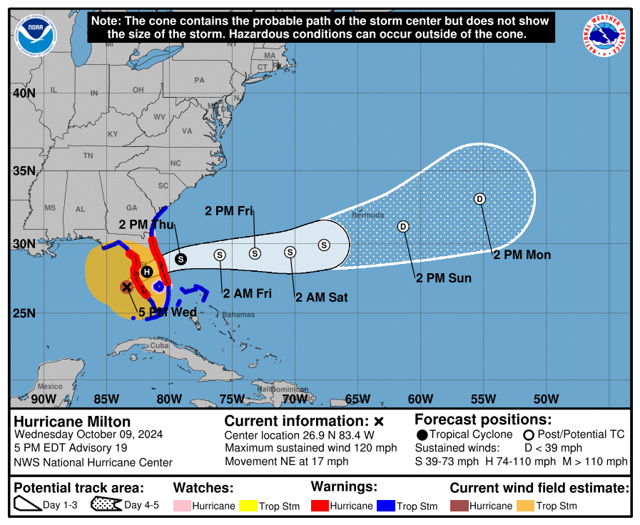
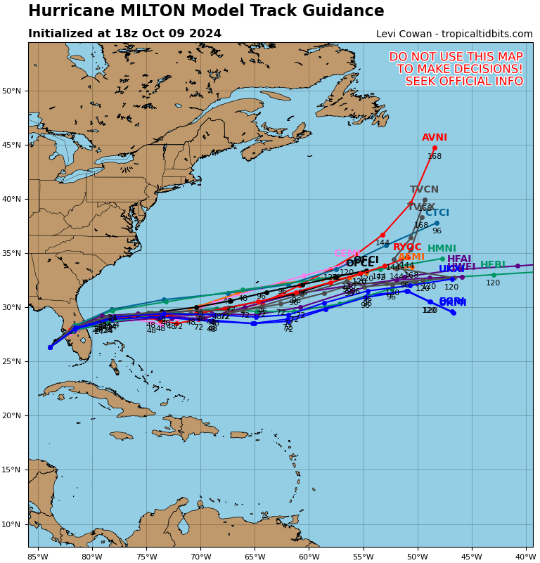
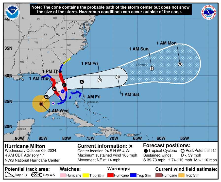
Since this morning there have been several changes with Milton. Most importantly it is encountering significant shear and it is weakening. During the day it has been moving faster and well north of where the NHC had anticipated it to be at this time. The models and the NHC track now take the center just south of Tampa Bay, near Sarasota and Bradenton.

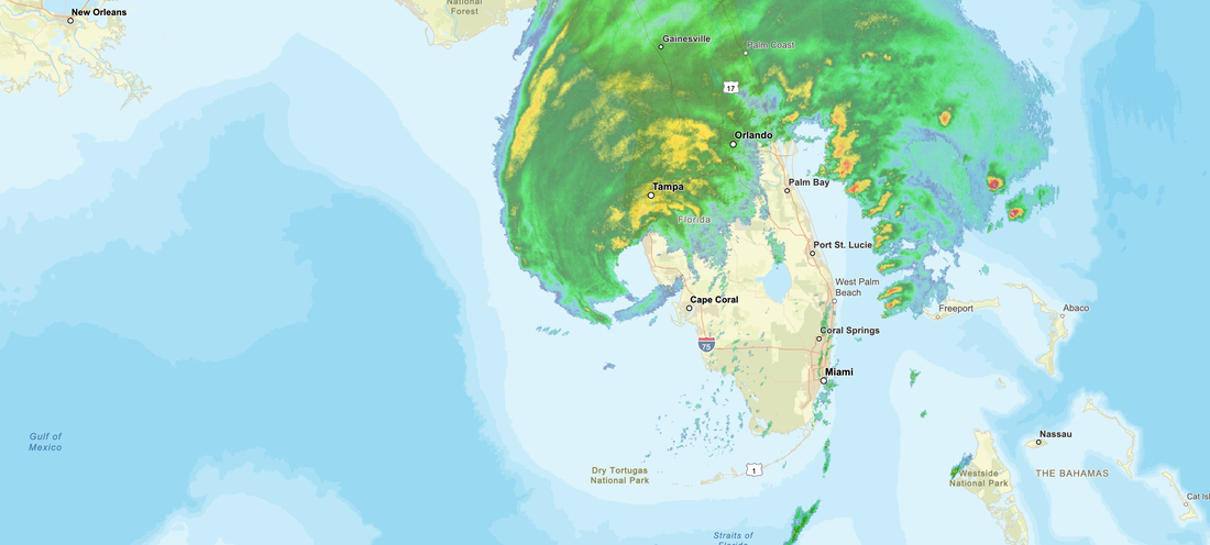
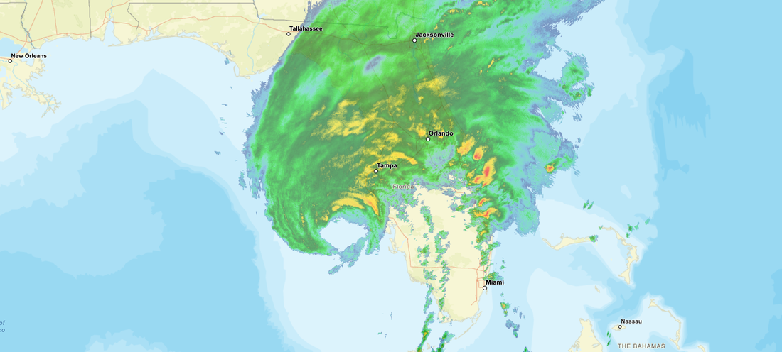
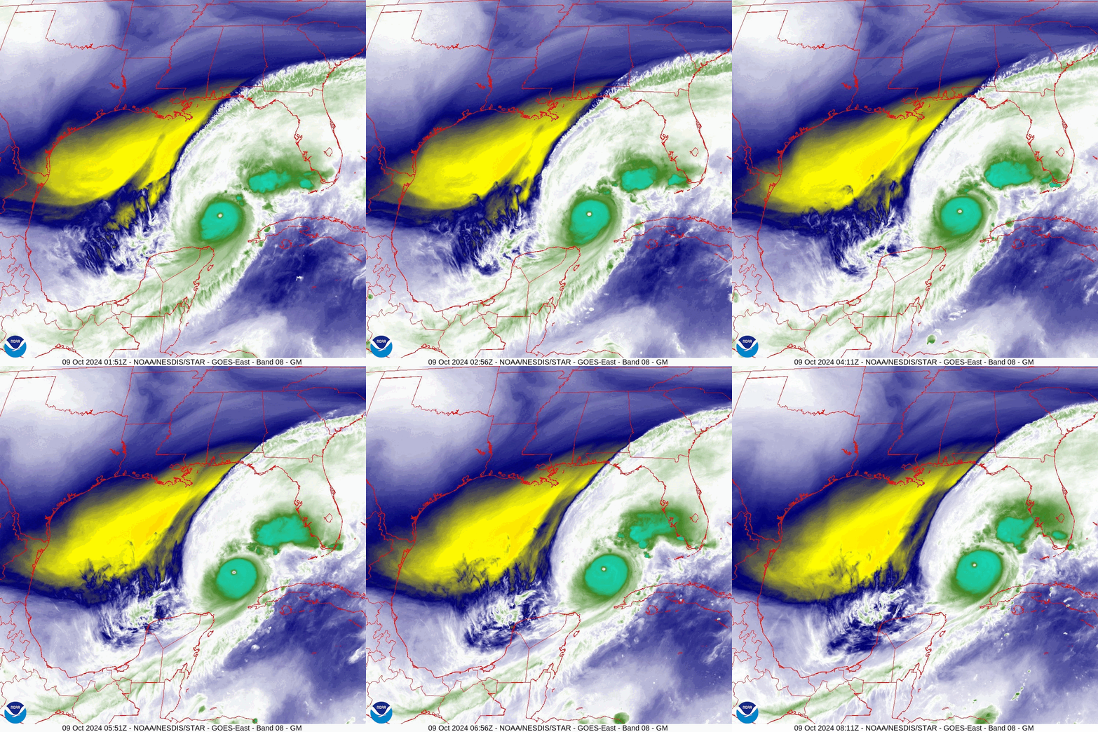
If you look at the radar below you notice first is that the eye now is very large, probably 40-50 miles across and all of the areas which we've been talking about the past few days will probably receive eye wall. The pressures have been rising steadily all day and have risen from 909 mbs this am to 948 mbs at 5 pm. They will continue to rise and Milton will continue to weaken. The center is around 70 miles from shore however with the large eye, the eye wall will arrive much sooner than the center. Most of the weather due to shear is now north of the center and the SW eye wall is now open. This will lead to further weakening. ? will it be enough, probably not however every little bit will help to reduce the extent of damage and injuries. The NHC is currently forecasting peak sustained winds to be around 115 mph, 100-110 may be more likely however it will still be enough to to cause extensive damage particularly to wooden structures. At least it is not the 165 mph Cat 5 we saw this morning.

SE Florida will likely experience little effects, especially with almost all of the weather now north of the center.

If you look at the water vapor loop below you will notice a lot of dry air behind it, yellows and blues. This is also helping to weaken it. After it passes this will move into the state.

Elsewhere everything else is moving out to sea.

Hoping everyone out there is safe.

Until next time,

                                                           Matt.
​
Picture
Picture
Picture
Picture

tropical update wednesday 10-9-24, 5 am

10/9/2024

 
Good morning.

Since yesterday Milton's track hasn't changed nor the reasoning, however if you look at the water vapor loop below you can see that Milton's eye has gotten smaller which has allowed it to fend off the shear north of it. You can see dry air moving in behind it however it has not yet begun to wrap into it. In light of this the NHC has adjusted their intensity forecast upwards and is now predicting it to be a 130 mph Cat 4 at landfall. They expect the shear to start affecting it today however, we still need to see that happen. The only other difference in their forecast is that they now anticipate the hurricane force winds to extend up to 35 miles on either side of the eye. In other words a 70 mile wide swath could experience hurricane conditions. Major hurricane conditions will be in the eye wall, the breath of which will depend on the size of the eye at landfall. At the intensity forecast I would expect a 20-30 mile wide eye, with an eye wall 3-5 miles wide, which means you would need to be within 20 miles of the center to get the major hurricane, a 40 mile wide swath. It will start to weaken after landfall.

It's forward speed has increased to 14 mph and it should approach the coast tonight.

I'll write again this evening.

Until next time,
                                                            Matt.
​
Picture
Picture

tropical update tuesday 10-8-24, 8 pm

10/8/2024


Good evening.

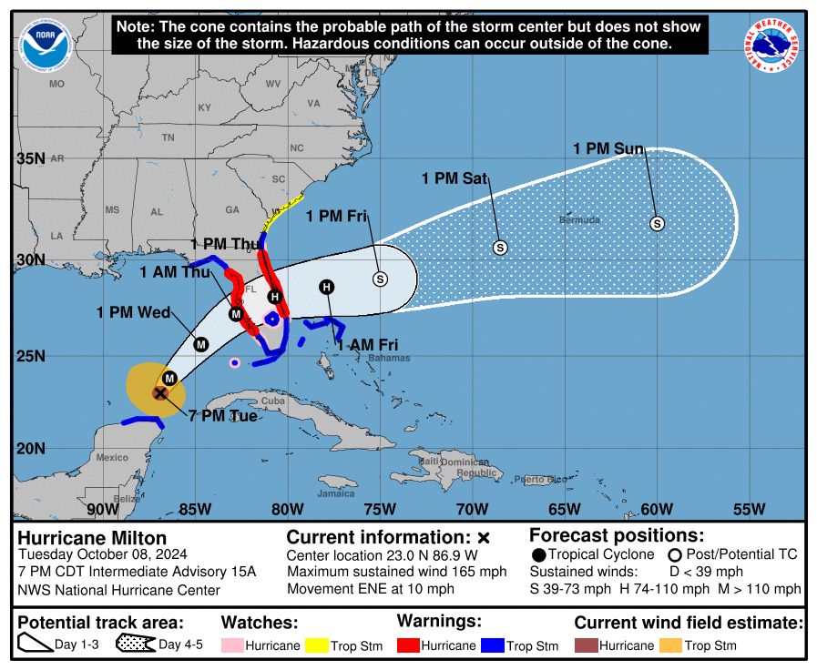
Here we go. Milton has remained south of where the NHC had forecast it to be at most of the day today. This has allowed it to re-intensity back to Cat 5 status. Over the past 3 hour however it finally appear to have begun its NE move and if its current trajectory holds it should make landfall along the west central Florida coast in the vicinity of Oaks Club/ Osprey Florida. (27.21 degrees north). The NHC has moved the center of its track a little southward though theirs still remains a little north of mine, towards Sarasota. 

Due to its intensity and small 10 mile wide eye it has been fending off the shear to its north. As it moves further north it should start to weaken, however it may not weaken enough. Only time will tell. The longer it maintains its compact structure, the less time it will have to weaken, however it will be encountering ever increasing shear as it moves northward. I really want to see how it does overnight.

The current forecast wind fields for when it makes landfall are as are as follows:

Hurricane force winds to extend 35 miles to the NE and SE of the center
Strong storm force winds (50-70 mph) to extend 80 NE and 60 miles SE of the center.
Weak storm force winds (40-50 mph) to extend 230 miles to the NE and 140 miles to the SE of the center.

On the NHC's track it would pass
35 miles south of Tampa.   (50 miles N of my track)
60 miles south of Orlando
200 miles north of Miami
35 miles north of Ft Myers ( 20 miles N of my track)
140 miles north of Boca Raton

SE Florida should experience winds in the 20s with gusts in the 30s in squalls. 1-3" of rain.
Those closer to the center of the path could receive up to 4-8 inches of rain. Potentially more including the pre storm rain tomorrow.
​
Ft Myers to Sarasota will probably receive the most weather. My best wishes extend to everyone in its path. I'm still hoping for a white knight to come in late in the forecast period and weaken it, every bit will help.

I will continue to monitor it closely and update as needed.

Until next time,

                                                              Matt.

Picture
Picture
Picture

tropical update tuesday 10-8-24, 5 am

10/8/2024

 
Good morning.

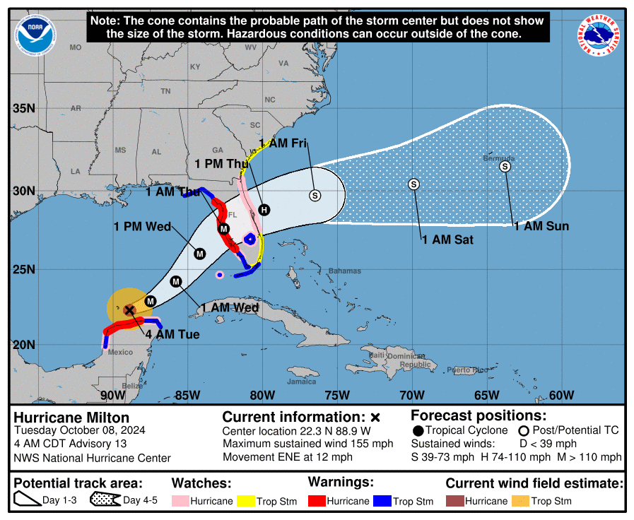
If you look at the water vapor loop below you will notice a few things. Most obvious is that Milton is starting to become more asymmetric and wobbling more, its eye is fluctuating and larger. It is also gaining latitude. It is starting to feel the affects of the shear to its north. It has weakened some and is currently a strong Cat 4 hurricane. Further weakening is anticipated and the NHC is currently forecasting a 125 mph Cat 3 at landfall, which is currently at the high end of their guidance. That would be a very strong hurricane and everyone in its path should be making preparations and plans.

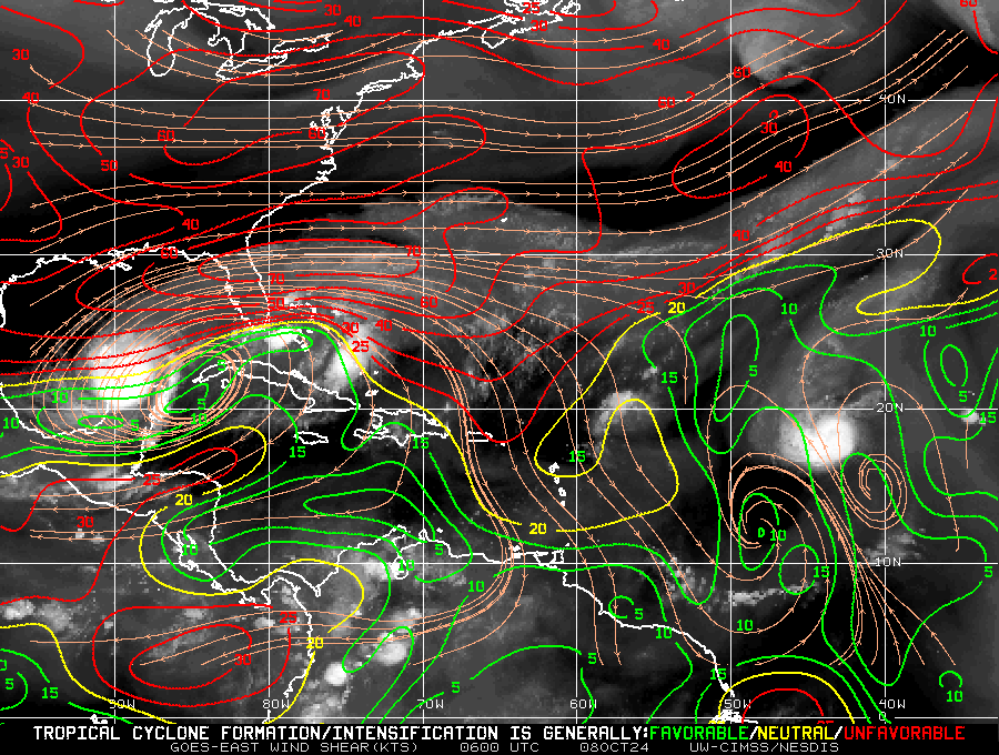
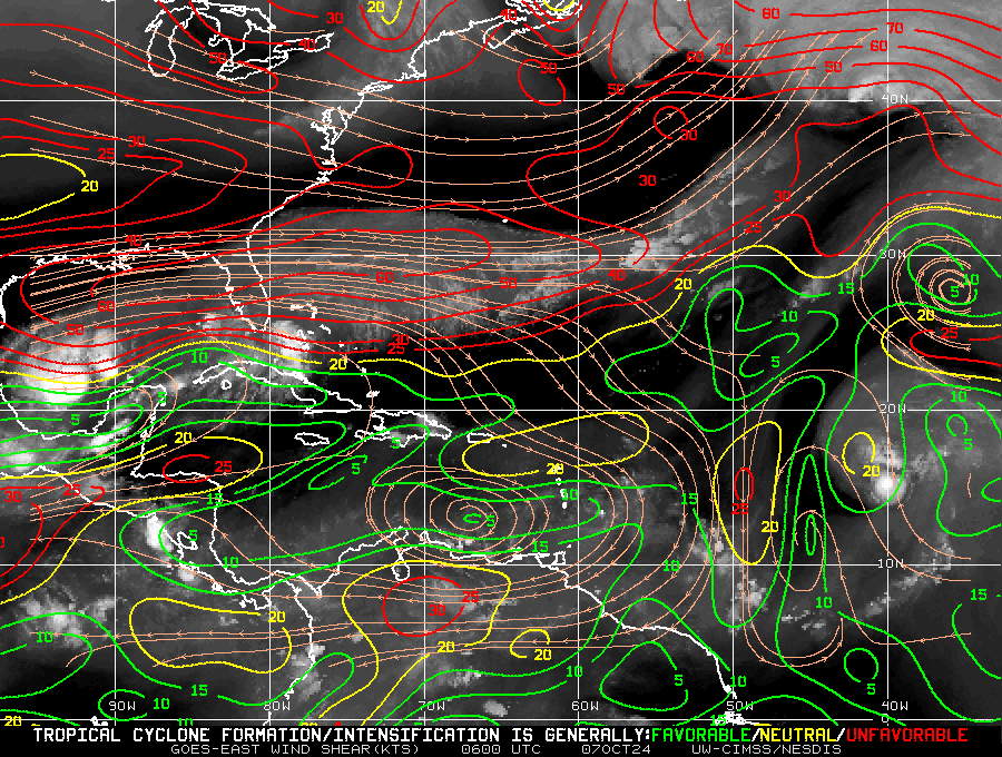
My track has not changed since yesterday. If you look at the wind shear analysis below you can see that Milton will be steadily encountering increasing shear as it gains latitude. We can only hope that it weakens as much as possible. We'll know more about intensity tomorrow.

I will write tonight about what specific regions can expect.

Until next time,

                                                       Matt.
​
Picture
Picture
Picture

tropical update Monday 10-7-24, 8 pm

10/7/2024

 
Good evening.

Today has been a historic day in the tropic with Hurricane Milton going from a 100 mph Cat 2 at 5 am to a 180 mph Cat 5 at 8 PM. Its barometric pressure of 897 mbs is the 4th lowest recorded in the Atlantic basin. (The lowest ever recorded was with Hurricane Wilma on 10/16/05 of 882 mbs.) Fortunately it will NOT be a Cat 5 at landfall along the West Coast of Florida early Thursday. The longest any hurricane has maintained Cat 5 intensity is around 24 hrs. Conditions have to be perfect for Cat 5s to exist. Conditions will not be perfect for Milton on Wednesday and Thursday.
If you look a the water vapor loop below you will notice a few things. First you will notice Milton's eye during its incredible intensification period. Watch it shrink. Like a ballerina folding in her arms the eye tightens as it intensifies. It goes from approximately 10 miles across to probably less than 3 miles, incredibly small. Next notice that it is starting to gain latitude. This is good news because the sooner it gets further north the sooner it will start to encounter significant shear. As it does so the eye should start to expand and the winds should start to lessen, just how much we will have to see.
 Also notice the dry air, yellow, to its north. This should start to entrain into the system tomorrow as it moves further north which should also tend to weaken it. 

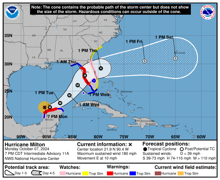
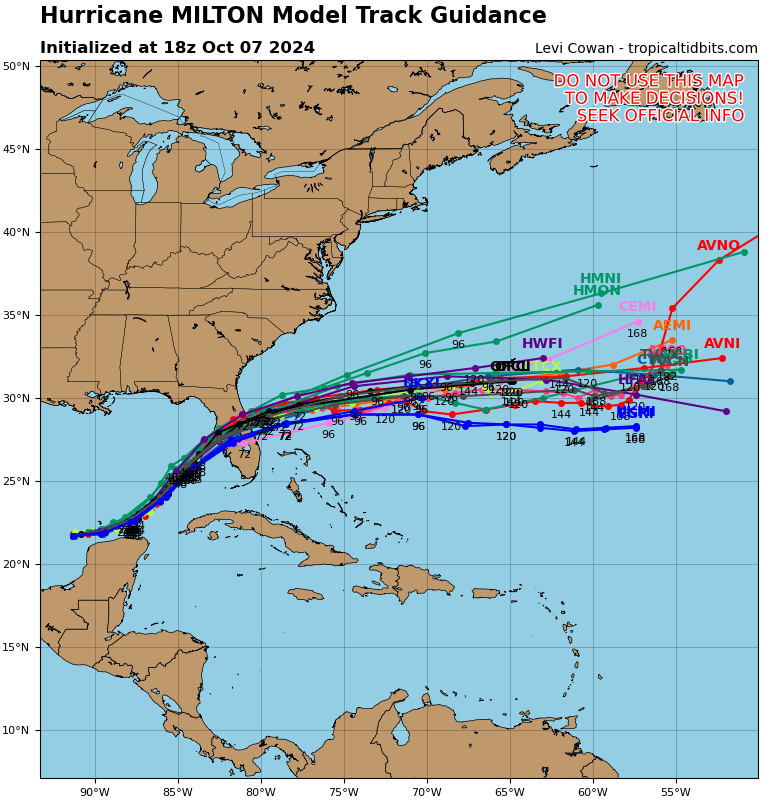
If you look at the models below you will notice extremely tight agreement amongst them over the next 24 hours after that there is a little spread. The models are currently pretty much in line with the track I noted this morning. The official NHC track continues to point to towards Tampa. 

Tomorrow will be key in predicting Milton's precise path. We should have a better idea by about this time tomorrow. The NHC is currently calling for landfall around 1 am Thursday morning. Timing will also be key. The slower it goes the better as it will give the shear more time to weaken it, ie if it arrives sooner it will be stronger, the later the weaker. In addition centripetal forces will tend to expand the wind field with time at the expense of intensity which along with widening of the eye should lead to some more weakening. All we can hope for is as weak a system as possible at landfall, though it will not be weak. By Wednesday morning we should have better idea as to just what we can expect. This is likely to be a significant hurricane. 

I'll be writing again tomorrow.

Until then,

                                                      Matt.

​
Picture
Picture
Picture
Picture
Picture

tropical update Monday 10-7-24, 5 am

10/7/2024

 
Good morning.

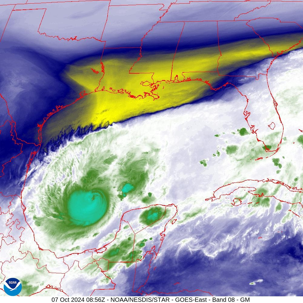
Milton has continued to intensify overnight. If you look at the water vapor image below you will notice a few things. First is that the cold front has moved further south and now spans across North Florida. Next notice that Milton has not moved very much since yesterday. Lastly notice that it has moved ESE and is well south of where the NHC had forecast it to be at this time. It remains in an area of low shear though notice that the shear has moved south as well.

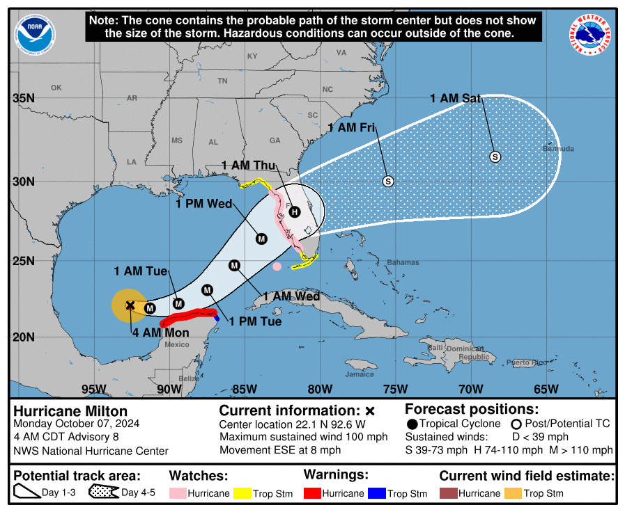
The NHC's track hasn't changed much. Based on its current position I suspect that a more southerly track will be more likely and my current track takes it mid way between Tampa and Ft Myers, currently centered near Oaks Club, FL, a little north of where Ian made landfall. The NHC is still forecasting it to be a Cat 3 at landfall. The intensity forecast will be difficult with this one due to the increasing shear. In general the further south it goes the potentially stronger it may me, as shear will steadily increase the further north it gets. Timing will also be a factor. The slower if goes the potentially weaker it may become due to a longer time in the high shear environment. I currently suspect it will arrive a little later that currently forecast due to how slow it is moving now.

Where it is tomorrow night will be key.

I'll Be watching it closely.

Until next time,

                                                    Matt.


Picture
Picture
Picture
Picture

tropical update sunday 10-6-24, 8 pm

10/6/2024

 
Good evening.

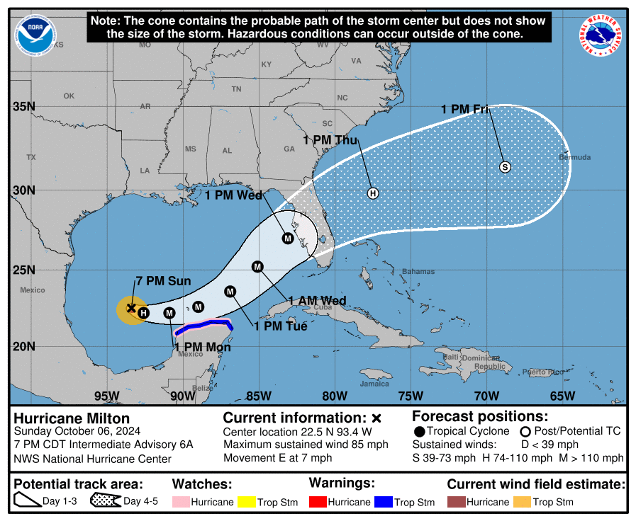
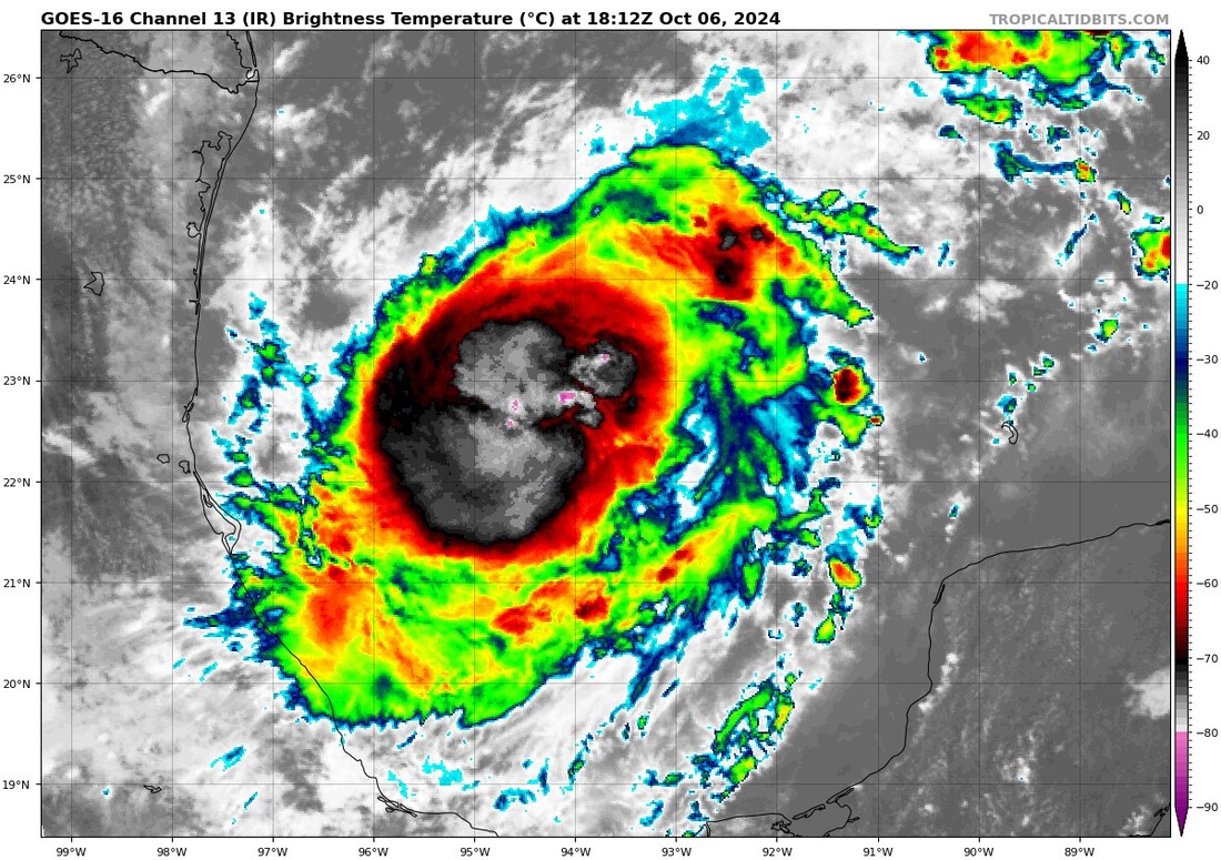
Just a quick update. Milton has been steadily intensifying all day and is currently an 85 mph Cat 1 Hurricane. The NHC's track and reasoning have not changed since this morning. The only  thing that has changed is their intensity forecast. They expect it to become a major hurricane tomorrow and peak out with winds of 145 mph, and then weaken to a 120 mph Cat 3 at landfall. Intensity forecasts are very difficult and both a stronger or weaker system could come ashore as discussed this am.

Milton is currently a very small storm with hurricane fore winds only extending 15-20 miles south of the center, none to its north. With a stronger storm forecast the wind field is also forecast to expand and Milton is expected to be much larger at landfall on Wednesday. As things become clearer I will give a more detailed analysis of what people in Florida can expect.

Until next time,

                                                            Matt.

​
Picture
Picture

tropical update sunday 10-6-24, 5 am

10/6/2024

 
Good morning.

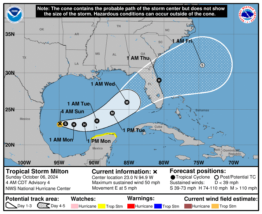
Since yesterday a couple of things have changed with regards to TS Milton's forecast. The biggest is the increasing uncertainty as to its projected intensity at landfall. If you look at the Wind Shear Analysis below you can see that Milton is currently in a low shear environment however once it starts to move more to the north it will encounter significant shear. Since yesterday Milton has moved little. If formed yesterday shortly after my forecast about 2 d prior to when the NHC had originally anticipated it to. This is going to give it more time over water. Unlike Helene, Milton is a very small system, this makes it potentially more susceptible to shear, however, rapidly strengthening small systems can sometimes overcome the affects of shear due to the rapid outflow above them while they are intensifying.

Milton is currently moving slowly eastward towards a stationary front across South Florida. A cold front over the SE US is forecast to move southward to over North Florida as Milton approaches Florida and the weaker stationary front is forecast to dissipate, this will allow Milton to be drawn further north. How much time it has in the low shear environment, before it turns NE will be key in how strong it becomes. The NHC expects it to become a major hurricane on Tuesday however it may rapidly weaken prior to landfall, or as noted above it may not. The intensity models vary from Cat 1 to Cat 5 with mean currently forecasting a 110-120 mph hurricane. It will be a tough call. It will start to accelerate to the NE as it approaches Florida.

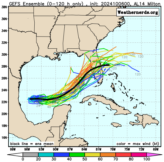
The models as you can see are all over the place and vary as to when Milton starts to perceive the northern front, for Florida the sooner the better as the intensity will likely level off or decline once it gets north of around 25 degrees.

I will be writing at least daily until Milton passes. Areas from Ft Myers to the Southern Big Bend need to prepare for possible hurricane conditions.

Until next time,

                                                          Matt.


Picture
Picture
Picture
Picture
Picture
Picture

tropical update saturday 10-5-24, 5:30 am

10/5/2024

 
,Good morning.

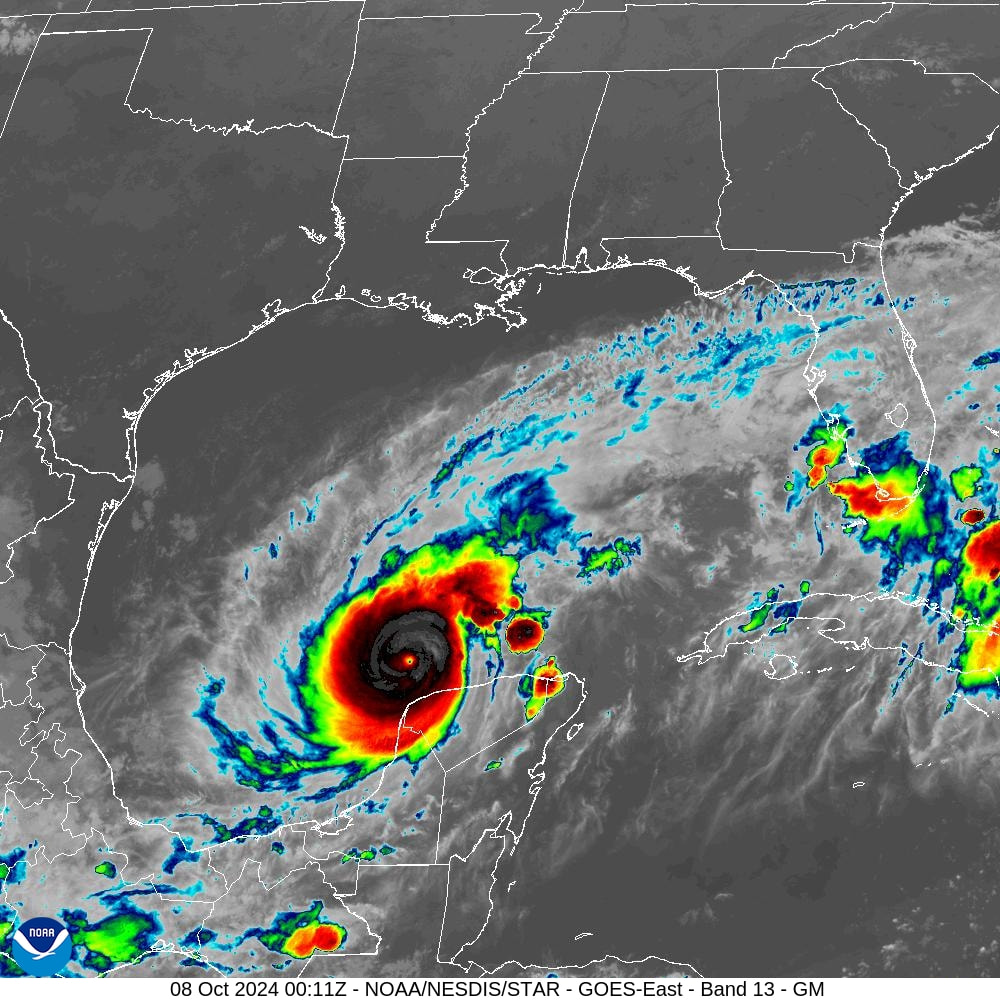
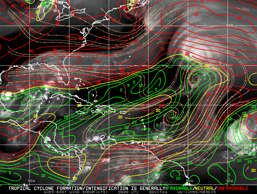
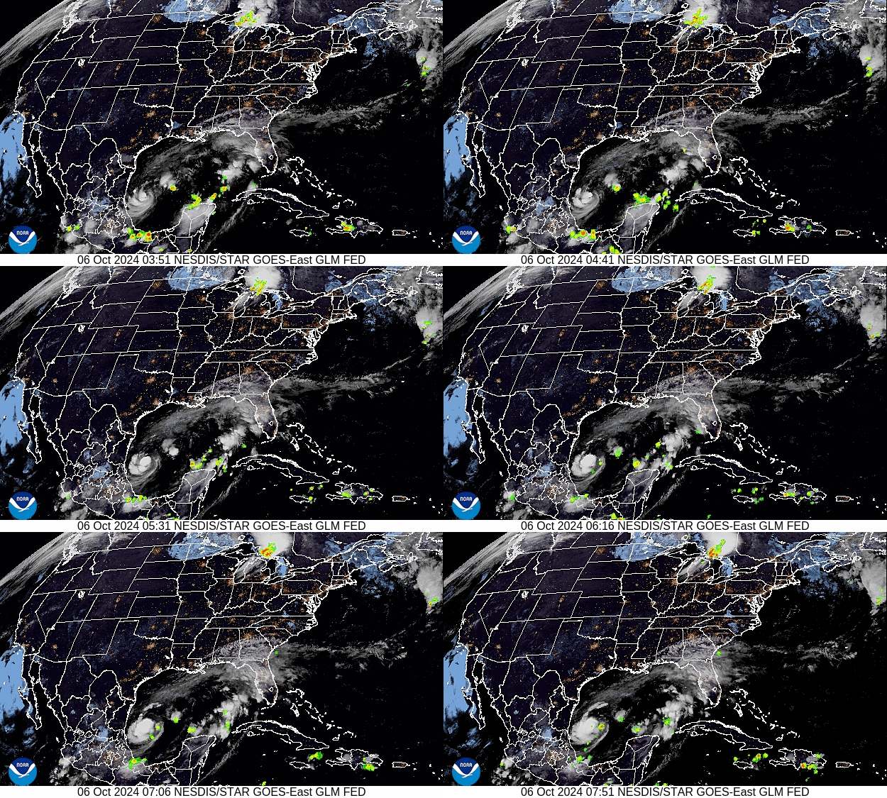
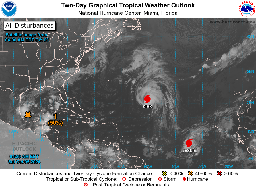
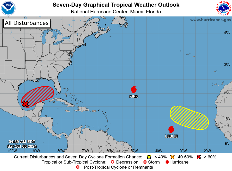
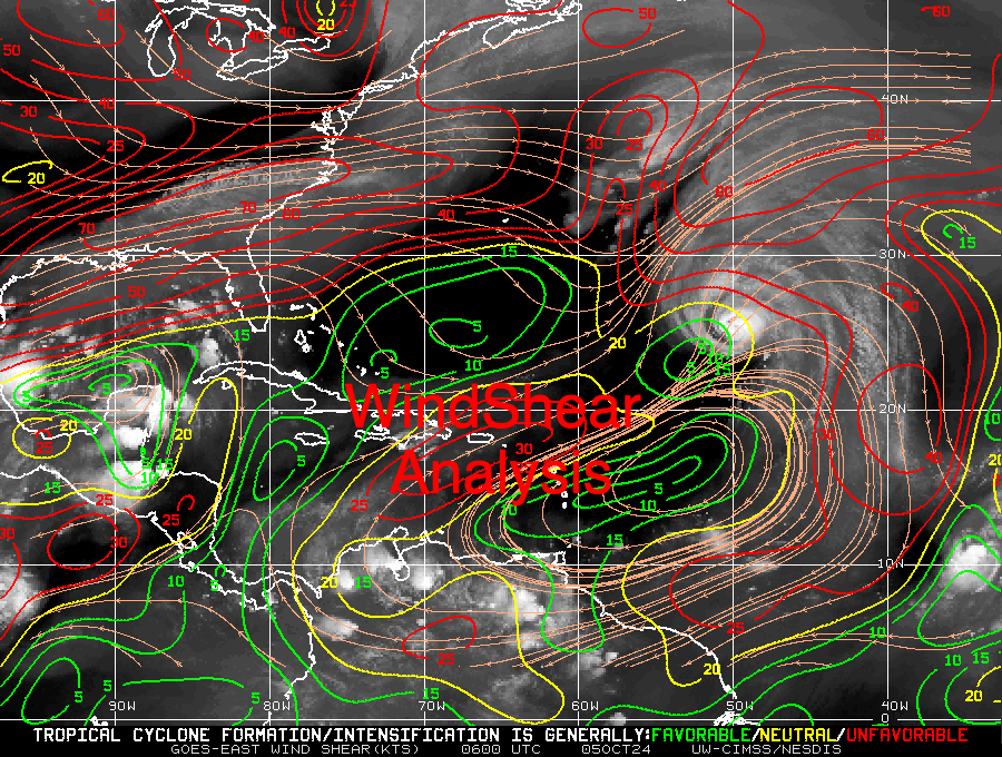
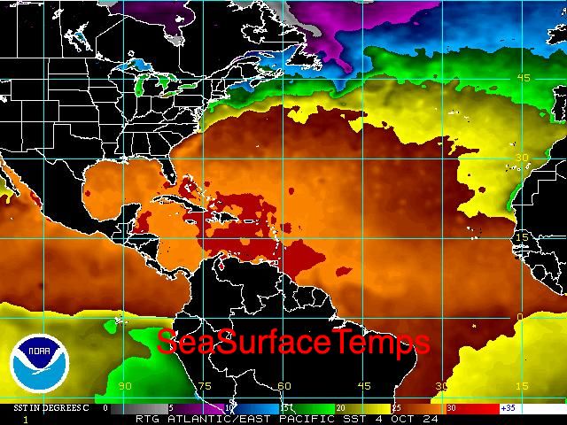
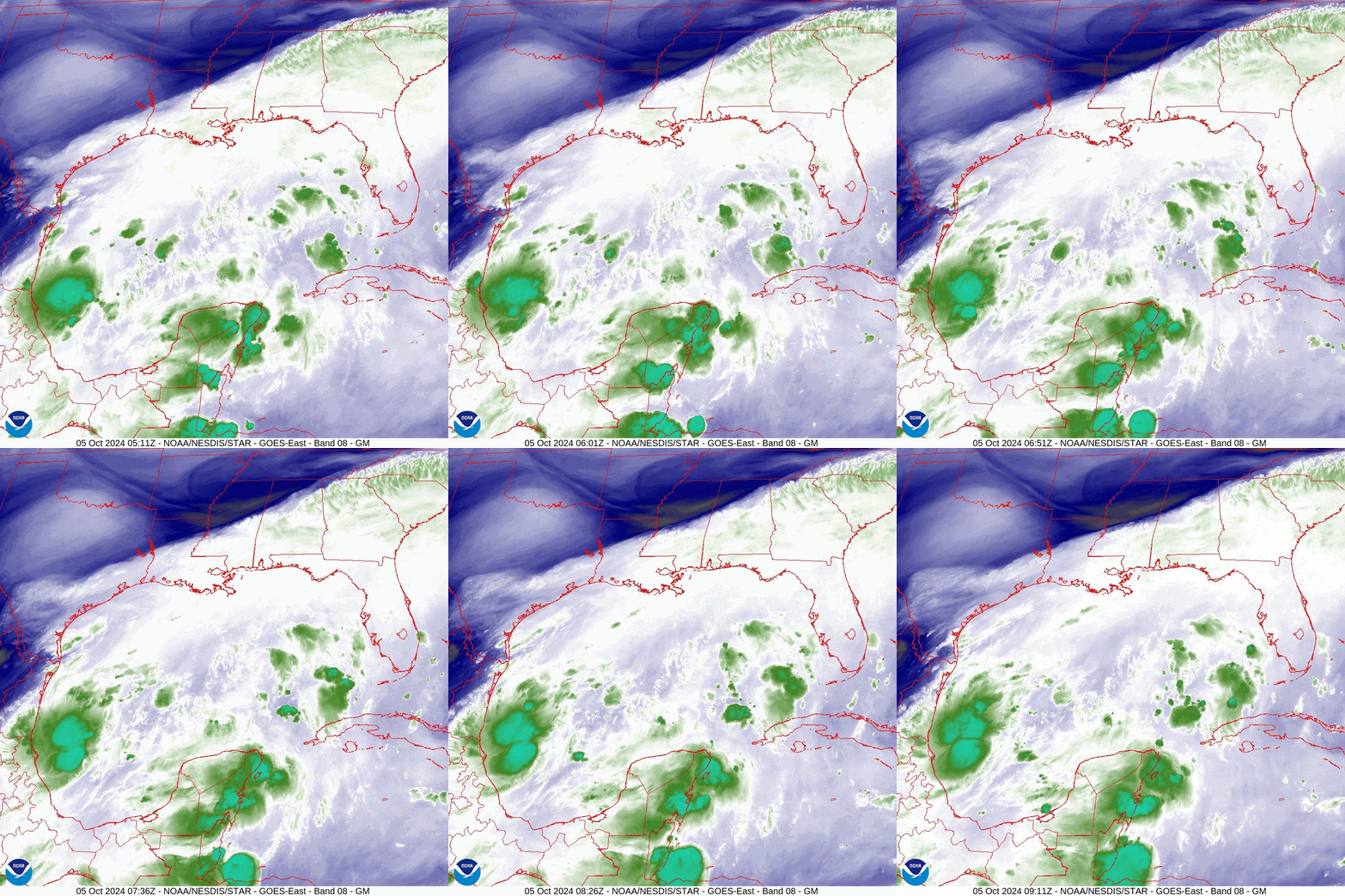
I am writing about the area of disturbed weather that I last wrote about on Tuesday, 10/1/24. At that time the NHC was watching a broad area of shower activity in the SW caribbean which was slowly moving norhtward and they had their watch area covering the entire Gulf of Mexico. Since then an area of low pressure has formed however it is well west of where they had anticipated, in the far southwestern Gulf of Mexico right along the Mexican coast. See satellite and water vapor images below. Wind shear remains extremely high across the Gulf, see Wind Shear Analysis below, and it is unlikely that this will become a strong system. Then NHC however is giving it a 80% chance of tropical development within the next 7 days. The most likely scenario is that we will see a Tropical Storm making landfall along the west central Florida coast late Wednesday or Thursday. The timing currently is highly variable as it has not formed yet.

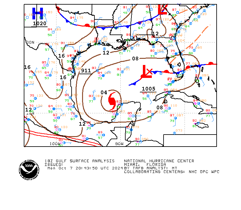
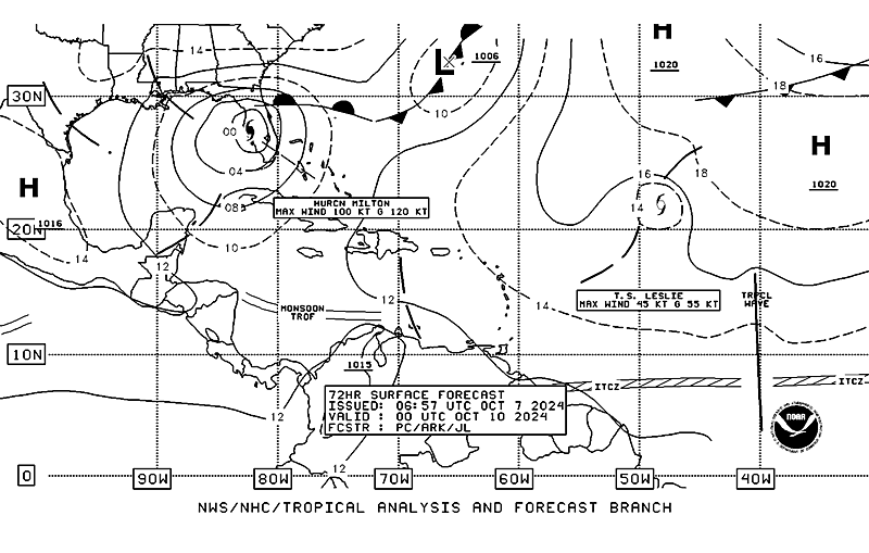
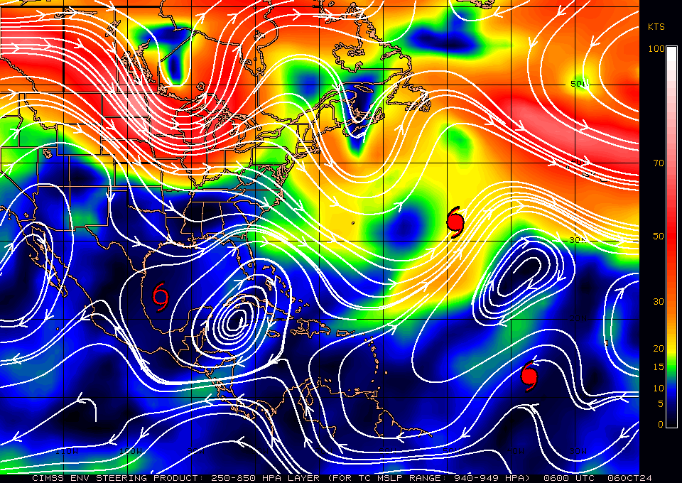
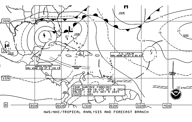
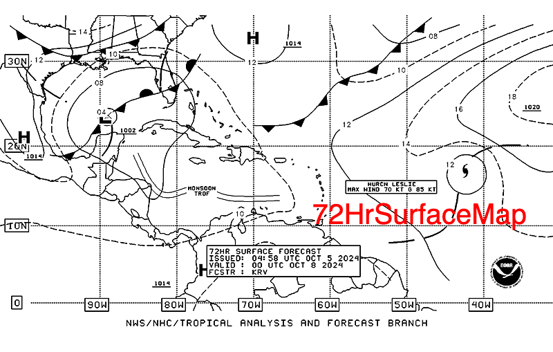
The most important diagram which I have included is the 72 hour forecasted Surface Map. An old frontal boundary and stationary front is forecast to cross Florida in the region of Lake Okeechobee. This will be the guiding force for this system. Where exactly it is on Wednesday will predict just where the center of the system makes landfall. That said as only a tropical storm is being forecast, weather is not usually focused in those systems and a fairly broad area will receive a lot of rain and modest winds. Just how much, its too early to say. Central and South Florida should see the most of it. With a stalled front in this region intermittent waves of moisture and rain will pass over these same areas for the next several days until after the system moves off into the Atlantic.

Elsewhere in the Atlantic, all of the systems out there continue to be forecast to move out to sea.

I am not overly concerned at this time but will be watching it closely.

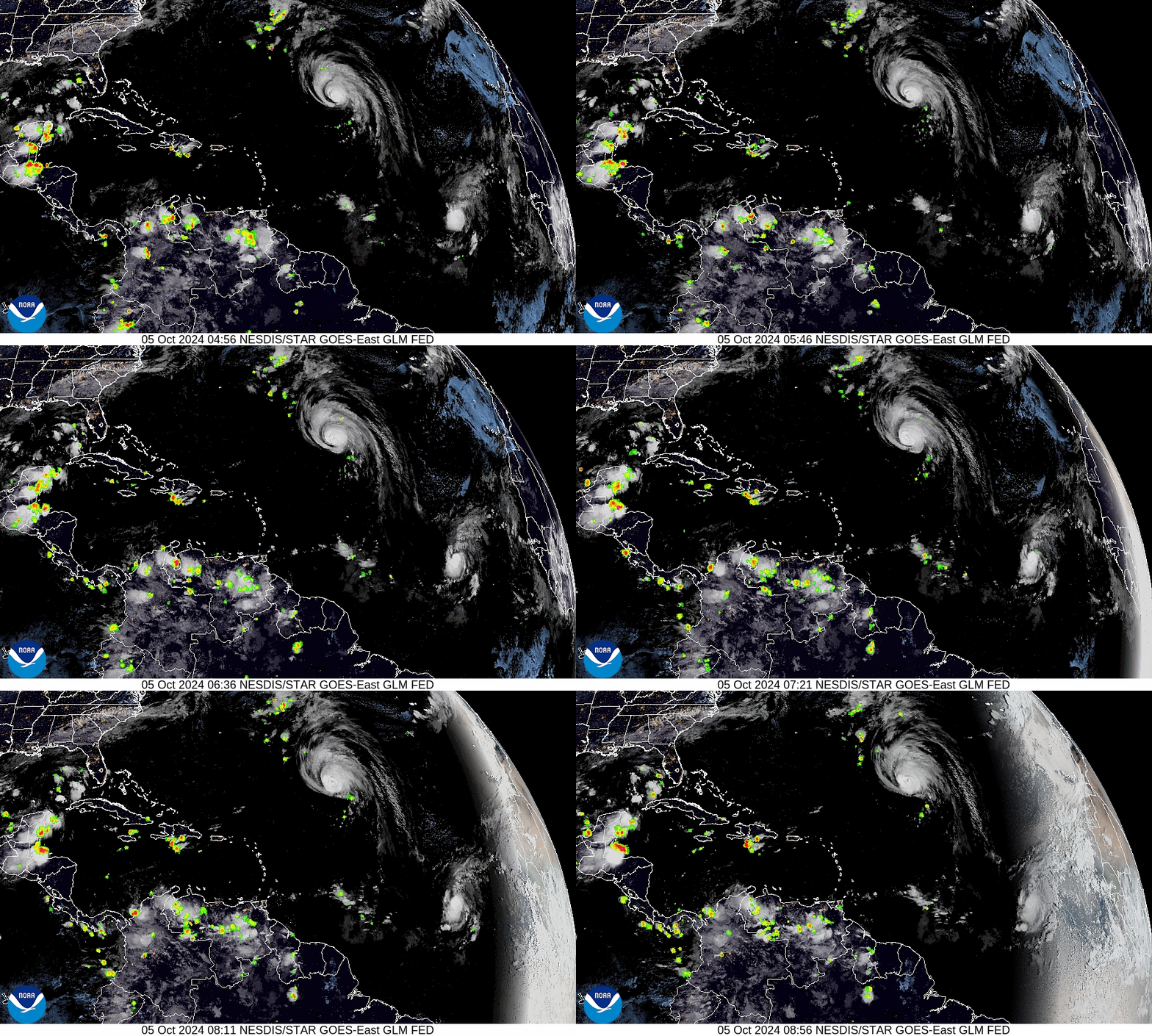
I have included a current visible satellite loop where you can all of the current lightning in the pre dawn hours. Notice Lake Maricaibo, the lightning capital of the world, along northwestern Venezuela.

Until next time,

                                               Matt.

​
Picture
Picture
Picture
Picture
Picture
Picture
Picture

tropical update tuesday 10-1-24, 8 am

10/1/2024

 
Good morning.

There are a few systems out there, though only one poses any threat to the US. All of the current Atlantic systems should all move out to sea and miss the US. A very weak disturbance in the SW Caribbean the NHC is giving a 40% chance of development over the next 7 days. A low pressure center currently does not exist though it is over very warm water. If it makes it into the Gulf of Mexico it will encounter high shear and is unlikely to become a strong system. Its greatest threat would be to to potentially add to the historic rainfall from Helene in North Carolina. Western NC has been devastated by up to 30+ inches of rain. Whole towns have been wiped out, many are without power or phone service. Hundreds of roads are closed/washed out. Many people are stranded unable to get out to get food or water. Its unbelievable. 

Helene was a massive storm which contained an unprecedented amount of water. It traversed some extremely warm water with a broad circulation and tracked right over the Gulf Stream's Loop Current for almost its entire trip across the Gulf of Mexico capturing its enormous heat content from the hot Caribbean which contained some of the hottest water in the ocean not having had a significant storm there last year. (ie 2 years worth of heat). It was a massive vacuum cleaner that dropped the water temperatures across the Western Caribbean and much of the Gulf of Mexico by almost 10 degrees. It then converted all of that heat energy into wind energy and rain.

If you really want to be impressed look at the Sea Surface temperatures map from my 9/23/24 forecast a week ago and compare it to the Sea Surface Temperature map of today. That really sums up what happened.

Until next time,

                                                       Matt.


Picture
Picture
Picture
Picture
<<Previous
Forward>>

    Categories

    All
    Preseason Update