Matt on the Tropics
Tropical Updates
  • Home
  • About
  • Archive (pre-blog)
  • Contact
  • Weather Links
  • Weather Trivia

tropical update, sunday, 10-7-18, 10 am

10/7/2018

 
Good morning.

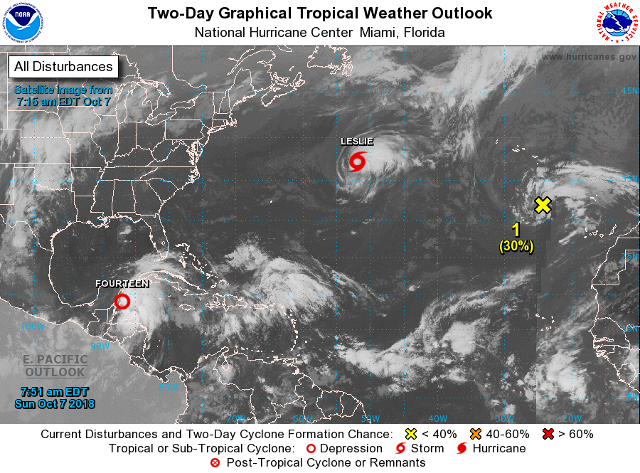
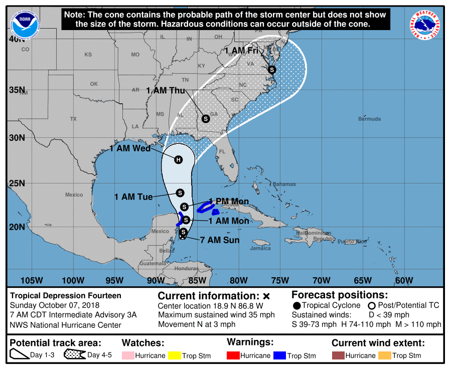
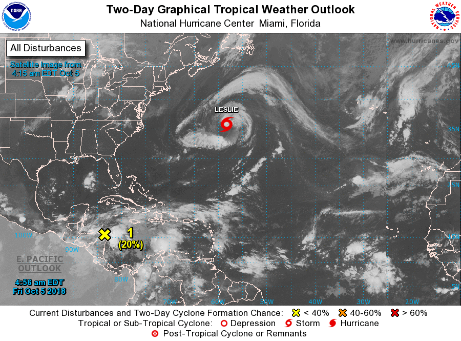
TD # 14 formed this morning along the coast of the Yucatan Peninsula. It is moving NNW (340 degrees) @ 3 knots and is expected to become Tropical Storm Michael later today. It is currently in an area of 20-30 knots of shear and development should be slow until it reaches the northern Gulf of Mexico where shear will lessen. (See Wind Shear Analysis below.) The NHC is currently forecasting landfall Wednesday afternoon between coastal Mississippi and the Big Bend area of Florida centered around the Florida Panhandle as a 75 mph Cat 1 Hurricane. Due to shear a strong Tropical Storm may be more likely but it is too early to say. The real key as to location of landfall and intensity will be timing. The slower it goes the further east will be its track and the potentially stronger it could become.

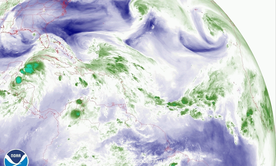
If you look at the first Water Vapor Loop below you will see several things. Moving left to right, first a frontal system across the west-Central US (extreme western portion  of image) with an upper level low over the Northern Gulf of Mexico, TD #14 just east of the Yucatan Peninsula, an upper level low North of Hispaniola, TS Leslie and then an upper level low in the far eastern Atlantic near the NW coast of Africa which corresponds to the "Yellow X" in the first diagram. Of these features it is the frontal system moving slowly eastward that will determine where Michael will make landfall. If the front were stationary it would go to Texas or Louisiana (see Surface Map), however it is moving. The slower the system moves the further east that front will be. Conversely if it should move faster, the further west the track, and the less intense as it would have less time to strengthen.

We'll just have to see, it should enter the southern Gulf of Mexico tomorrow afternoon. Where it is in relation to the current projections will be key.

As its shear is out of the west moisture will increase across all of Florida starting tomorrow. Expect increased rainfall the next few days.

I'll write again tomorrow, possibly in the afternoon when we should know more,

                                                                 Matt.


Picture
Picture
Picture
Picture
Picture
Picture

tropical update, Friday 10-5-18, 7 am

10/5/2018

 
Good morning.

I am writing about an area of disturbed weather in the western Caribbean. The NHC is currently giving it a 20% chance of development in the next 2 days and a 60% chance for development within the next 5 days. It is currently drifting slowly NW and is in an area of high shear. (See Wind Shear Analysis, bottom diagram, everything in red is hostile for development.) As you can see once it enters the Gulf of Mexico the shear will subside and development will be possible. Currently Louisiana appears to be at greatest risk. I'll be keeping an eye on it and will let you know if it develops, or not.

Elsewhere Leslie is moving out to sea, and pulling heat out of the ocean.

Until next time,
                                               Matt.


Picture
Picture
Picture

tropical update sunday, 9-23-18, 10 am

9/23/2018

 
Good morning.

There are several new features in the Tropics this morning though none appear to be of great concern at this time. If you look at the Water Vapor Loop, second graphic, you will see several things.
First an upper level low spinning over the Gulf of Mexico, with a frontal system moving north of it over the Central US, next an upper level low east of Florida, labeled #1 on 1st diagram , a large stronger upper level low labeled #2  in red, spinning over the central Atlantic, next a whisp of clouds being heavily sheared in the southern central tropical Atlantic east of the Lesser Antilles (this is TD #11) and last a spin of convection in the far south eastern Atlantic (this is TS Kirk).

Briefly, the NHC is giving #1 a 30% chance of development in the next 5 days. It may approach the Carolinas however the front across the Central US moving east should keep it offshore as well as shear it preventing significant development.

#2 is expected to move off to the NE away from land.

TD #11 is undergoing significant shear and is about to enter an area of even greater shear. (See Wind Shear Analysis below). It will likely dissipate in the next 1-2 days.

TS Kirk is currently in an area of low shear however it is being limited by dry air to its north and west,(see Saharan Air Layer Analysis, SAL, last diagram). In looking at the Surface map it is being steered quickly west by high pressure to its north. It is currently moving west at 18 mph however that speed is expected to increase to 25 mph or more. This is good news because it will even further enhance shear over it once it reaches the south central Atlantic just south of where TD #11 is now. Both the GFS and European models are forecasting dissipation in 5-7 days after it enters that area of high shear which is extensive. (See Wind Shear Analysis below.)

I'll be watching if things should change however I anticipate that the high shear over the Caribbean and southwestern Atlantic (likely due to a developing El Nino) should keep a damper on southern systems.

Until next time,                      Matt.


Picture
Picture
Picture
Picture
Picture
Picture

Tropical Update Monday 9-17-18, 8 am

9/17/2018

 
Good morning.

The Carolinas had a record weekend with regard to rainfall. It will take some time for the waters to recede and to clean up all of the damage from Florence. Rainfall totals have exceeded 30" in places and it is still raining in certain parts however it should hopefully finish up today as Florence pulls away quickly to the NE. We may be able to get storm totals by tomorrow.
Peak winds occurred over the Outer Banks with highest winds recorded on land being sustained of 83 mph and a peak gust of 106 at Cape Lookout, NC.

Elsewhere in the tropics Isaac dissipated as expected. The NHC is currently giving it a 10% chance of regeneration over the next 5 days. Saharan dust has re-established itself over the tropical Atlantic, (see below). The first wave in over a week should emerge off the coast tomorrow however it appears to be north of the "Sweet Spot" and will be running into a lot of dry air. We'll see but its prospects of making it to the US are low.

Overall we look ok for now,

                                                       Matt.


Picture
Picture

tropical update Friday 9-14-18, 6 am

9/14/2018

 
Good morning.

At 6 am Florence was located at 34.2 N & 77.6 W. Florence is making landfall now between Wilmington and Porters Neck NC. The eye, which is about 20 miles wide, should pass over both areas with highest potential winds in the Porters Neck area. So far the highest sustained wind recorded has been 83 mph at Cape Look Out, NC in the Outer Banks. This may be surpassed this am in the Wilmington area. Gusts will be higher. After coming on shore it is expected to drift slowly SW over land. This is relatively good news, compared to if it had remained just offshore, as it should continue to weaken. Florence is making landfall, as projected yesterday, as a Cat 1 hurricane however due to the duration of the event and copious rainfall it is still going to cause a lot of damage, especially to trees and areas along the coast that receive storm surge. It is going to be a long weekend for the Carolinas.

Elsewhere, Isaac, due to dry air and shear, has been downgraded to a tropical depression and the NHC is forecasting dissipation within the next 1-3 d. Hopefully it will not regenerate after it reaches the western Caribbean however it should remain well south of Florida.

All else is quiet on the Eastern Front.

Until next time,                        Matt.


PS. For what its worth the NHC did an outstanding job in forecasting Florence's track. In looking back over my posts for this storm they've had the Wilmington area as the center of their track for the past 5 days.
Picture
Picture
Picture
Picture

Tropical Update Thursday, 9-13-18, 9:00 AM

9/13/2018

 
Good morning, I 
There have been some interesting developments overnight with regards to Florence and Isaac.

First, with regards to Florence. In looking at the water vapor loop this morning (image #3 below), Florence is starting to slow and shift its movement from a NW to a WNW direction. We also notice that the eye is no longer well-defined. In support of this, when Hurricane Hunters investigated the system this morning, they found a peak wind of only 98 mph. Florence is currently a Cat 2.  If you look at the surface map (image #4 below), you can see an interesting development. The high pressure over the Midwest has merged with the Bermuda High, creating a blocking ridge to its northwest. This is why Florence will turn to the west and stall, followed by a slow drift to the southwest. The exact location of where this occurs will be key to how much weather the Carolinas receive. Due to shear and upwelling as it slows and approaches the coast, Florence should continue to weaken and is likely to be a Cat 1 storm when it makes landfall. Its windfield, however, is quite large, with hurricane-force winds extending 60 miles to the northwest and 50 miles to the southwest , and with storm-force winds extending 140 miles NW and 110 miles SW. This will create a prolonged weather event, though not of the intensity as originally forecast.

With regards to Isaac, there is good news. If you look at the Two-Day satellite map (image #5), you can see that all its weather is displaced from the center. Peak winds have decreased to 45 mph and the NHC is currently expecting it to degenerate into an open trough in 2-4 days. More likely this will happen in 1-2 days as it is entering an area of even higher shear. In looking at the surface map, even if it should regenerate, it should still miss the state of Florida and is unlikely to pose a significant threat to the US.

Elsewhere, Joyce and Helene are weakening, and the area in the Gulf doesn't look like it will have time to develop.

Until next time,
Matt (and Cassie)
​
Picture
Picture
Picture
Picture
Picture

tropical update Wednesday, 9-12-18, 7 am

9/12/2018

 
Good morning.

There have been a few significant changes since yesterday.

First with regards to Florence the NHC and most of the models are now in agreement that Florence will stall off the central coast of North Carolina Thursday night and Friday. This will lead to a few things. Most important will be how far off shore it stalls. It will certainly enhance rainfall totals and if close to shore prolong the wind and surge event. It will also cause it to weaken. Both due to increasing shear as it approaches the coast but also due to upwelling of colder water under the eye when it moves too slowly.
After it stalls its forecast will become very difficult. In general once a tropical cyclone stalls its course inherently becomes very hard to predict. Of note is that the small upper level low that was between the NC coast and Florence yesterday has moved SW. You can see it on the satellite water vapor loop below just off the coast of Georgia. Its not very large or strong however once it is stalled it may be one of the few things to influence it. If you look at the flow along the SC coast it is towards the SW. This is may be why the models are now trending to the SW after it stalls. The NHC is currently calling for a landfall near the NC/SC border as a Cat 2 storm, however the track is likely to continue to change. If the upper level low persists and doesn't move out of the area I would not be surprised by a track further south.
Time will tell.

Second with regards to Isaac note that the models have shifted northward and are no longer pointing at Central America. Fortunately as previously discussed it has weakened due to shear and the projections are for it to remain a tropical storm in the Caribbean however once it leaves the Caribbean things may change.

We're just going to have to wait on that one too. Currently it does not appear to pose a significant threat to South Florida but as I stated earlier, until it is north of us we'll have to continue to keep an eye on it.

I'll probably write next tomorrow afternoon.

Until next time,                Matt.


PS. As a general rule the worst part of a major hurricane is the eye wall. It is where the strongest winds and surge occur. The eye wall usually is around 5 miles thick. Florence's eye is currently 20 miles wide therefore the swath of ocean below it that is experiencing major hurricane conditions is around 30 miles wide. I usually add 5-10 miles to account for the wobbling motion of the storms, thus conservatively 40 miles wide. Outside of the eye wall one usually does not experience sustained winds over Cat 1, though it can vary with the size and intensity of the storm. Therefore unless the center of the eye  were to pass within 20 miles of you (at its current eye size) you would not likely experience major hurricane conditions. Note the eye could expand significantly after it stalls, ie. pay close attention to the size of the eye.

Picture
Picture
Picture
Picture
Picture

Tropical update Tuesday, 9-11-18, 7 am

9/11/2018

 
Good morning.

There are a few interesting changes of note in the tropics this am.

First with regard to Florence it is moving faster though not as fast as the NHC had predicted and it is moving further north than they had projected. It is currently approximately 40 miles north and east of where they had expected it to be at this time, per yesterdays forecast. As a result of this and other data the models have shifted north and have slowed some. They also found the high pressure over the Mid-West to be stronger than they had anticipated. In addition a new disturbance over the NW Caribbean is forecast to move into the western Gulf of Mexico, (See top 2 diagrams) . If that occurs it would tend to  strengthen and nudge NE the Mid West high. If Florence slows enough it may be just enough to keep it off shore. If you look at the models below the Global models still bring it on shore however 30-40% of the GFS models remain offshore. This trend is up significantly from yesterday. Trends are important. In general the Globals do a better job in dealing with upper level lows than the GFS, however when we are just dealing with high pressure systems GFS tends to out perform. There is currently only one tiny upper level low between the Carolinas and Florence. This should have a negligible affect on it therefore I would favor the GFS solutions for this storm. It does not mean that it will miss, but the possibility may be increasing. We'll have to see.
The Outer Banks still appear to be at greatest risk. It is expected to slow down before landfall as the high pressure to its west moves eastward. It may reach Cat 5 status today however due to shear and slowing it is expected to be a Cat 4 as it approaches the coast.

With regard to Isaac, due to shear it has weakened some and there has been an increase in  spread of the models with several turning it north into the open Atlantic. (See "Models Isaac" below.) The NHC's track has not changed. We're just going to have to wait on that.

In the bottom diagram you can see that the Western Gulf of Mexico remains very warm. The system over the NW Caribbean may use that to strengthen, fortunately it should not have much time to develop significantly but we'll see.

I have my fingers crossed for the Carolinas.

Until next time,                 Matt.

Picture
Picture
Picture
Picture
Picture
Picture
Picture
Picture

Tropical update Monday, 9-10-18, 9:30 am

9/10/2018

 
Good morning.

In reviewing the data this morning on Florence it is looking less likely that it will not make landfall. The NHC anticipates it to speed up which it is starting to do and make landfall before the approaching cold front from the west can deflect it out to sea. Of note the NHC is making a special trip today to evaluate the high pressure system over the Mid West that is driving the cold front. That information probably won't be factored into their forecast until this evening. We'll have to see. Of note is that Florence is south of where they had projected it to be at this time on Saturday. This may lead to a shift in the track southward closer to the SC/NC border. There are still numerous variables in play  however the Carolinas need to prepare for a major, probable Cat 4 hurricane.
Due to the approaching front it is expected to slow down as it approaches the coast and they currently expect it to stall over land leading to potentially catastrophic flooding.

We'll have to see how things play out but it has the potential to be a devastating event.

Isaac continues to move west. Note some of the models pull it north into the Atlantic, see bottom diagram. Time will tell.

Until next time,         Matt.


Picture
Picture
Picture
Picture

tropical update, sunday 9-9-18, 9 am

9/9/2018

 
Good morning.

Since yesterdays update little has changed with the NHC's projections though there are a few things of note.

First regarding TS Florence as anticipated the NHC has shifted the center of its track from South Carolina to North Carolina. Also note that Florence is moving very slowly. In general the slower the motion the more likely that things will change, thus the track. Notice the frontal system across the Central US in the first diagram. It is moving slowly eastward. This will hopefully be the "White Knight" to spare the Carolinas and the rest of the East Coast from Florence's eye wall.
My track for Florence has not changed from yesterday.

Isaac and Helene tracks so far have not changed from yesterday.

Elsewhere things are quiet.

Until later,             Matt.


Picture
Picture
Picture
Picture
Picture
<<Previous
Forward>>

    Categories

    All
    Preseason Update