Matt on the Tropics
Tropical Updates
  • Home
  • About
  • Archive (pre-blog)
  • Contact
  • Weather Links
  • Weather Trivia

Tropical Update Saturday 9-2-17, 11 am

9/2/2017

 
Picture
Good morning.

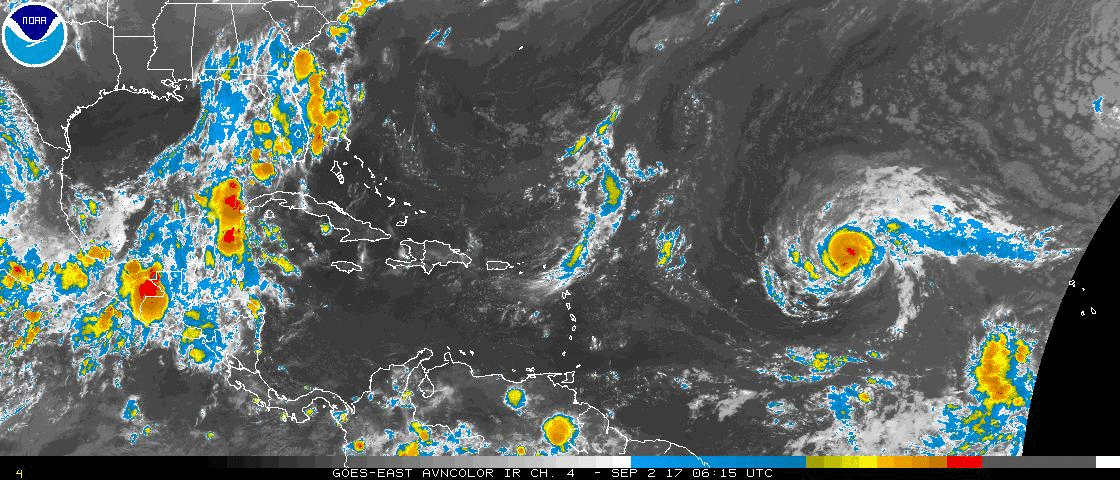
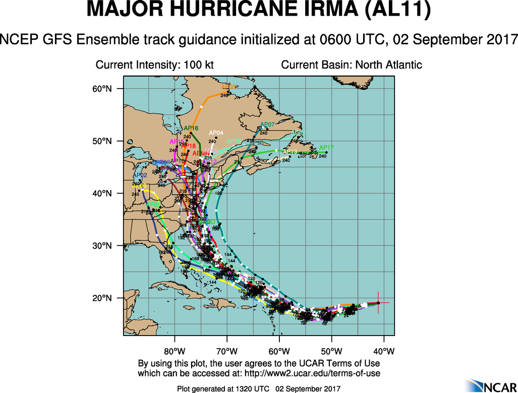
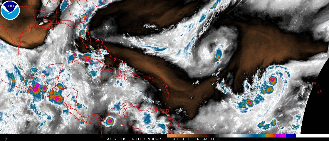
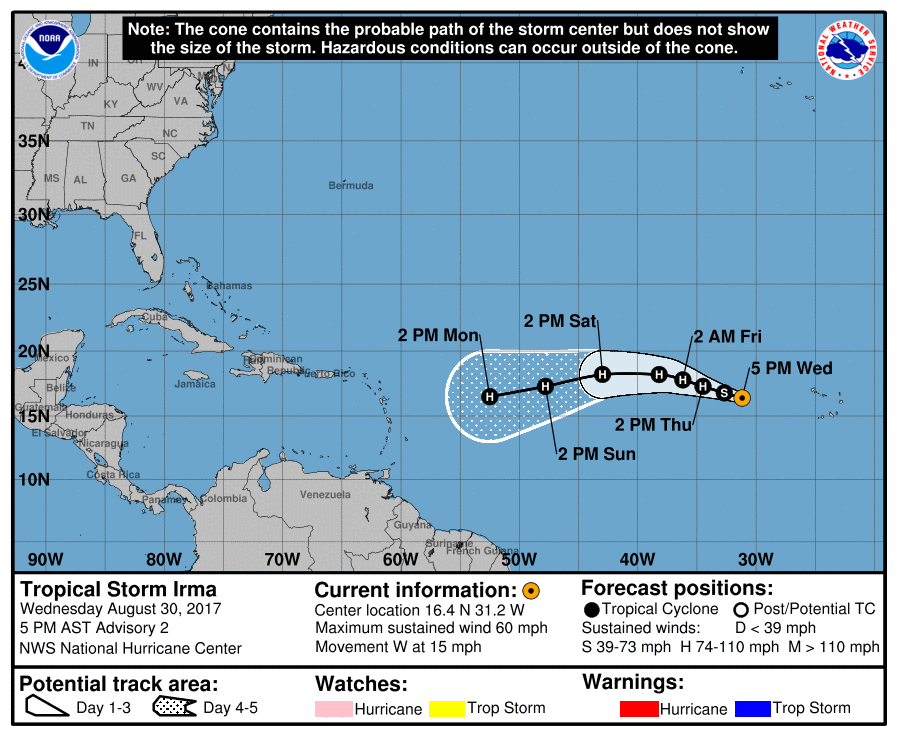
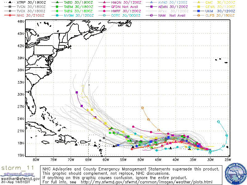
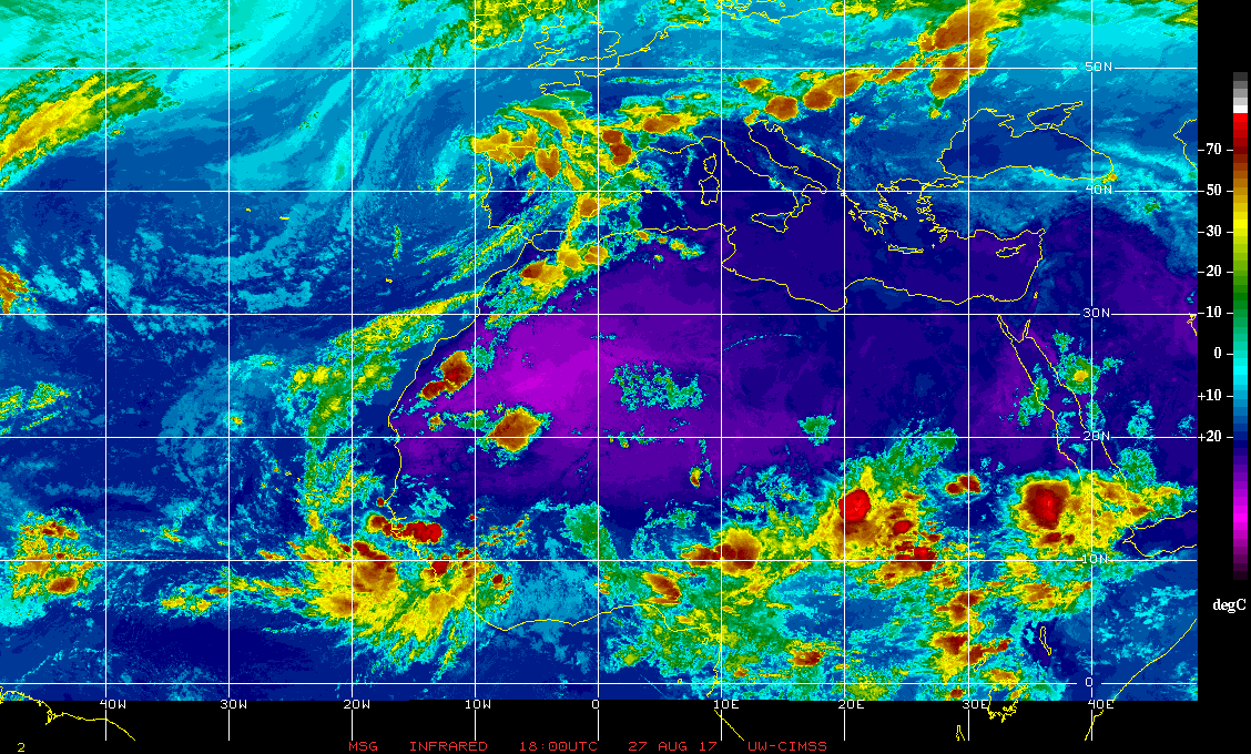
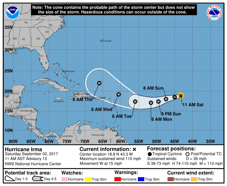
At 11 am Hurricane Irma was located at 18.8 N & 43.3 W and was moving just south of west at 15 mph. Due to somewhat cooler water and dry air around it , see below Sahara Air layer image, it has weakened a little and is now a Cat 2 storm. This will be temporary as conditions will become more favorable as it approaches the Leeward Islands and the Bahamas. In looking at the Infra Red loop below you can see a frontal trough has moved a little eastward and is now across NW FL extending into the eastern Gulf of Mexico. This should help to keep it away from Florida. The main concern for Florida would be if Irma would slow down, building high pressure over the Atlantic could shift it westward. This is expected to occur later in the forecast period and which is why models are suggesting a more westward move toward the US east coast after it is past Florida. (see Ensemble models below). It is still too early to make an accurate prediction as to ultimate landfall for Irma. There are numerous variables in play which are in constant flux. For now the risk for Florida appears to be lessening however we'll just have to see.

I'll be writing daily for now. Elsewhere the wave to the SE of Irma has weakened, but I'll continue to keep an eye on it.

Until tomorrow,                         Matt.
Picture
Picture
Picture

Tropical Update Friday 9-1-17, 7 am

9/1/2017

 
Picture
Picture
Good morning.

At 5 am Hurricane Irma was moving WNW @ 12 mph, see above, first diagram. Yesterday am the models of Irma were trending southward however due to steady WNW motion over the past 24 hours they are now trending northward which may be good news for us all. An upper level low in front of Irma is moving SW, (see above, second diagram, Water Vapor Loop) which could shift her slightly more northward. The key will be if Irma enters the Caribbean or not. Yesterday it was looking likely, today that is not the case. If Irma stays north of the Caribbean a track through or near the Bahamas followed by a turn to the N and then NE near or along the Coastal Carolinas, hopefully missing the US, would be more likely. If it enters the Caribbean a track toward the NE Gulf Coast would be more likely.


Elsewhere in the tropics one of the other Tropical Waves over Africa has emerged off the coast. see below. This one is significantly lower that Irma, about 10 degrees and has a much greater chance of getting into the Caribbean. This is the one we'll really need to keep an eye on. It is almost 2 weeks away and the weather patterns will certainly change by then. We'll just have to see.

*** FYI waves coming off of Africa between 10 and 12 degrees N latitude are the ones which pose the greatest potential threat to South Florida. Those are the ones with the greatest chances of getting into the Caribbean and getting south of us. Note due to the Coriolis Effect all storms want to move north. They only move in other directions when something is preventing them from moving north. ***

Have a good weekend and I'll keep you posted.   Matt.

Picture

Tropical update 5 pm Wednesday 8-30-17

8/30/2017

 
Picture
Good evening.

Tropical Storm Irma formed this afternoon, see above. It is in an area conducive for development and it is expected to become a hurricane tomorrow. Despite the fact that it is fairly far north, high pressure to its north is expected to deflect it to the SW, see above. Most of the models however still turn it away from South Florida into the Atlantic, (see below), however  I am concerned that high pressure over the Atlantic could build to the west and it could potentially threaten Florida. It is way too early to make any accurate predictions at this time. Current weather patterns would move it to our east however weather is not static and in a week when it approaches the Caribbean things may be different. If it were to get south of Cuba I would be concerned with a landfall along the Florida Panhandle. We'll have to see how things progress over time but we're not out of the woods yet with this one.

Elsewhere Harvey is finally moving inland however has left historic rainfall in its wake. Areas around Houston have received up to 52" of rain and 46" have fallen in Beaumont, TX leaving behind devastating flooding. Two more waves over Africa will be emerging, like Irma did, over the next couple of days and will need to be watched as well. It generally takes about 10-14 days for storms to make it from the coast of Africa to our vicinity.

I'll probably write again on Friday,                  Matt.
Picture

Tropical Update Sunday 8-27-17, 4 pm

8/27/2017

 
Good evening.

Hurricane Harvey made landfall late Friday night on southern Matagorda Island, Texas near the town of Rockport, TX. Peak wind gust recorded was 132 mph in Aransas, just west of Matagorda Island. Peak wind in Rockport was 108 mph. Fortunately for Corpus Christie, Harvey passed 31 miles to its north (north of the NHC's forecast track) and as hurricane force winds only extended 20 miles to the south of the center they did not experience hurricane conditions. Peak wind gust recorded in Corpus Christie was 69 mph. Harvey is currently a minimal Tropical Storm with peak winds of 40 mph. Peak wind gust in Texas in the past hour has been 41 mph. Almost all of its weather is currently north of the center which is now just west of Victoria, Texas.

The biggest effect of Harvey will be rainfall. Houston has already received 25" of rain and it is still raining heavily. Many major roads are currently flooded and the NWS is predicting total accumulations of up to 50-60" possible !!!

Closer to home the low pressure system near the SW Florida coast on Friday is now off the coast of Georgia and South Carolina. We have received about 5 and a half inches of rain so far since Thursday from this system Some development is possible as it moves along the South and North Carolina coastal regions on its way out to sea. It would likely not be more than a Tropical Storm for them, if it should form and if it were to make landfall or a close enough approach.

Elsewhere in the tropics there is not much at present. There are a couple of large thunderstorm complexes over tropical Africa which will bear watching for development after they emerge off the coast in about 5-7 days. (See Infra Red image of Africa below.)

Until next time,            Matt.

Picture

Tropical update Friday 8-25-17, 7 am

8/25/2017

 
Picture
Good morning.

Hurricane Harvey this morning is intensifying and headed toward coastal Texas. The NHC is currently forecasting a landfall tonight just north of Corpus Christi, however radar images this am suggest a move a little more northward and my current track brings it onshore over Matagorda Island & Peninsula near Seadrift, Port Lavaca and Victoria. Though intense Harvey is a compact storm with Hurricane force winds only extending about 20 miles from the center. At landfall they are forecast to extend 30 miles to the NW and 20 to the SW. Steering forces are weak and it is forecast to slow down and meander as it approaches land, see above. Hopefully its meandering will occur over land and not immediately offshore which would be devastating. In addition to wind due to slow movement it will be a major rain event with areas with over 2 feet of rain forecast.

Closer to home an area of low pressure just off the SW Florida coast is forecast to drift NE over the peninsula this weekend. Shear overhead and land interaction should prevent any development until it is past Florida. Some development is possible after it emerges into the Atlantic as it moves away from shore. Expect enhanced shower activity this weekend in South Florida from this system.

Wishing my best to Texas,             Matt.

Update Tuesday 8-22-17

8/22/2017

 
Picture

Hillside Orchard FaRM JUST SOUTH OF cLAYTON, GA.

Picture

same view 10 seconds later

Picture
Picture
Good afternoon.

For those of you that missed it the Total Eclipse yesterday was incredible. We went to a perfect place, well worth a visit with or without an eclipse, Hillside Orchard Farm just south of Clayton GA off of route 23. Farm stand, bakery, café, corn maze, U pick apples, blackberries and figs in season. At first the sky gradually drew darker, like dusk, then suddenly as if a switch was turned off it was dark and crickets started chirping loudly. We looked up to see an amazing corona with a visible solar flare. We were in the path of totality with 2 min 37 seconds of darkness. When the sun returned it was instantly bright and we had to turn away and twilight returned.
In 2024 a total solar eclipse will return, this time from Texas to Maine. If at all possible try to make plans on being in the Path of Totality for that one !  It is something that everyone should experience first hand at least once in your lifetime.

In the tropics all of the systems which I spoke of last have fizzled. The only one of concern is the remnants of Harvey which have been pulled northward by an upper level low in the Gulf of Mexico. If it should reform expect models to shift significantly to the NW towards the Texas coast. Nothing else is out there that poses a potential threat to South Florida at this time.

Until next time,              Matt.
Picture

Tropical Update Friday 8 am, 8-18-17

8/18/2017

 
Picture
Picture
Good morning.

I'm writing about a few areas in the tropics which we'll need to watch. See charts above. The first is a tropical wave just north of Hispaniola which is on the back side of an upper level low. It is headed our way and should enhance rain chances this weekend. High shear from the upper level low should prevent development. Harvey is headed toward Belize and should not affect us. The area in the mid Atlantic labeled 1 is headed in our general direction. It is currently in a high shear environment and should remain so until just prior to getting into our vicinity which should be middle of next week. If it should form it would probably be a tropical storm at best. Depending on the exact location of the center if and when that occurred it would tend to head either toward South Florida (currently around or south of the Lake Okeechobee region) or approach the coast and then move N and NE missing the state. The area labeled 2 and the wave currently over Africa should both be pulled north into the Mid Atlantic Trough and miss the US.

I'll write further as things develop, or not.

Have a good weekend,    Matt.

PS. I'll be in NE Georgia on Monday 8-21, hopefully weather permitting, watching the Eclipse !

Tropical Update Sunday 8-13-17, 11 am

8/13/2017

 
Picture
Good morning.

The area of low pressure over the Central Atlantic which I spoke about in my last update is now TD #8 and will likely become TS Gert later today. Due to factors previously discussed it is already north of us and moving away and posses no threat to Florida or elsewhere in the US. The disturbance over Africa which I had mentioned previously has emerged off the coast of Africa and has the potential to develop over the next week. It is still too early to make any accurate predictions for this one but I'll be watching it and will let you know if it should develop.

                    Matt.

Tropical Update 8-7-17, 7 AM

8/7/2017

 
Picture
Good morning.

Just a quick update. TS Franklin formed overnight and is currently headed for the Yucatan Peninsula and Mexico. The NHC is forecasting it to be a 60-65 mph tropical storm at landfall. It is entering a low shear environment and currently has deep convection and I would not be surprised if it becomes a hurricane prior to landfall. Currently I anticipate landfall a little south of the NHC track above, into Northern Belize. It poses no threat to South Florida. Elsewhere surface low pressure over the Central Atlantic is currently interacting with a large upper level low north of Puerto Rico and is undergoing significant shear. The net affect of this interaction will be either it will be torn apart or deflected to the north. Both of which scenarios make a South Florida impact unlikely. There is nothng else out there at present. A low pressure area currently over Central Africa will emerge off the coast in about 4 days, this will be the next area that we'll need to watch.

Have a great week,

Matt.

Tropical Update Tuesday 7-18-17,  7:30 am, TS Don

7/18/2017

 
Picture
Good morning.

Just a brief note on TS Don, see chart above for location and intensity. Don is being steered by a very strong Bermuda high, well to our south. It should move along the northern coast of South America. Due to high shear across the Caribbean it is anticipated to dissipate in 3 days. It currently does not pose a threat to South Florida or the US at this time. Unless things change I do not anticipate the need to write further about this system.

My best to all,       Matt.
<<Previous
Forward>>

    Categories

    All
    Preseason Update