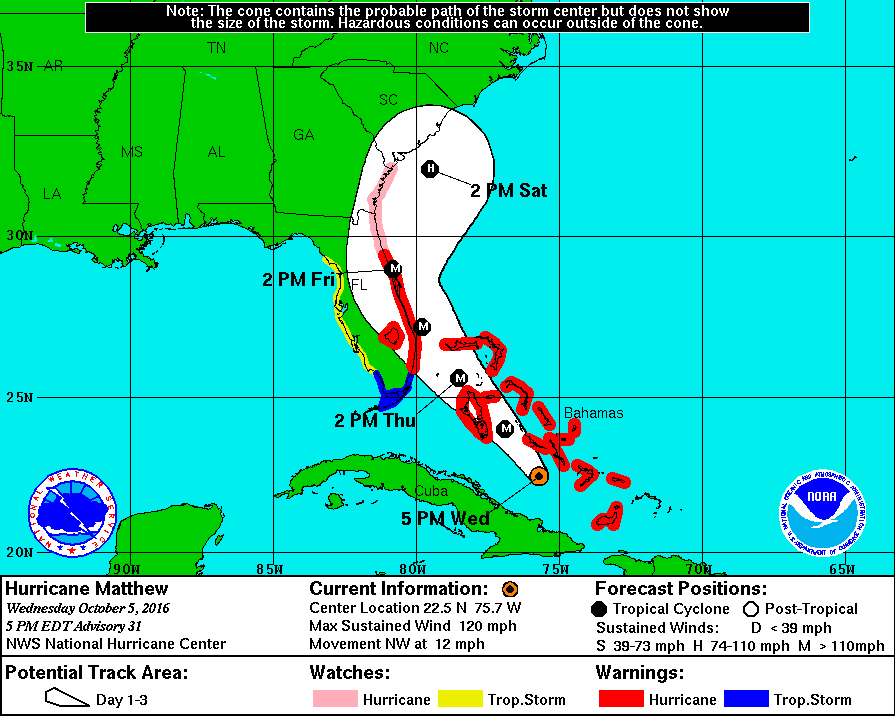
Matt on the Tropics
Tropical Updates
  • Home
  • About
  • Archive (pre-blog)
  • Contact
  • Weather Links
  • Weather Trivia

Tropical Update 8 am Monday 6-20-17

6/19/2017

 
Good morning.

I'm writing about 2 areas of disturbed weather in the tropics this am.

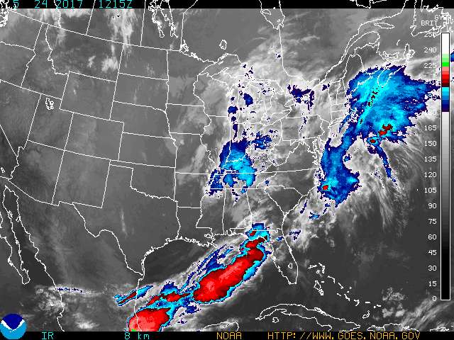
NEITHER poses a threat to South Florida at this time. One is approaching the northern coast of South America. It should move along the northern coast where it is expected to encounter significant shear on Wednesday. It is expected to dissipate on Wednesday or Thursday. The other is currently over the Yucatan Peninsula. It is expected to emerge over the SE Gulf of Mexico today and development is expected. There is significant shear to its north. The NHC is forecasting it to become a tropical storm. Due to shear it is not expected to strengthen to a hurricane. It should move northward and currently Louisiana appears to be at greatest risk. It is expected to make landfall along the northern Gulf of Mexico as a  tropical storm in 2-3 days. Unless things change I do not anticipate the need to write further about either of these systems.

My best to all,   Matt.

Potential Severe Weather Alert for South Florida                  5-24-17,  11 am

5/24/2017

 
Good morning .
I am writing about the potential for severe thunderstorms with possible hail this evening and tonight. An approaching cold front is associated with cold temperatures aloft as well as very high winds aloft.

Attached is a recent Infrared image of the SE US and Gulf of Mexico. No specific precautions, just keep an eye out for any local alerts as there will be a slight risk for tornados.

Picture

Preseason Tropical Update 2017

3/21/2017

 
Subject: Pre-Season Tropical Update 2017  

Good morning.
June 1st marks the official start of the 2017 Hurricane Season.
2016 was an above average season in the Tropical Atlantic due to a weak La Nina with 15 named storm, with 7 Hurricanes and 3 Major Hurricanes. On average there are 12 named storms and 6 Hurricanes with 3 Major. Most of the storm last year formed late in the season, 10 from September on, 7 in September. Last year South Florida was threatened by 2 storms. Hermine which the NHC had initially targeted to hit SE Florida,  went through the Florida Straits (as forecast) eventually making landfall as a minimal Cat 1 in the Big Bend area of Florida; and Matthew which fortunately passed about 30 miles to the east of NHC's forecast track. Miami saw minimal effects though Florida from West Palm Beach north was effected along with coastal Georgia, South Carolina and North Carolina.
Rainfall at my house totaled 65.76 inches a little below my 27 year running average of 68.13". Months of heaviest rainfall were May, July, August and October led by August with almost 13 inches.
I am expecting an average year in the tropics for 2017. We currently have a neutral El Nino cycle. Last years La Nina is over and it is possible that a weak El Nino may form later in the season. If that happens it could lessen late storm activity. We also have above average temperatures in the eastern Atlantic and the Gulf of Mexico which potentially could lead to stronger storms if they do form in those areas. But remember you need 3 conditions to make a tropical system. Water temperatures  80 degrees or greater, spin and the absence of shear. The most important being the absence of shear. El Ninos are associated with an increase in shear across the Caribbean.


May the winds of shear blow and the Mid Atlantic Trough send all the storms out to sea!


Wishing everyone a great summer and a quiet Hurricane Season,
                                                                                                                                Matt.


Tropical Update Saturday 10-8-16, 8 am

10/8/2016

 
Good morning.

At 8 am Hurricane Matthew was located @ 32.5 N and 79.8 W and was moving NNE with peak winds of 85 mph. Earlier this am the center of its eye made its first US landfall along coastal South Carolina. In looking at radar this morning it is currently centered over Charleston, SC. The eye now measures 40 miles across which will expand the Hurricane force wind field. Heavy rains are affecting Georgia and South Carolina and will spread into Coastal North Carolina later today. The extent of Matthew effects have been remarkable and historic.

After tomorrow it will move out to sea and is expected to weaken significantly under heavy shear. We'll have to reassess around Tuesday to see what is left and whether we will have to deal with it again!

Until the next time,                                           Matt.

Picture
Picture

Tropical Update Friday 10-7-16, 7 am

10/7/2016

 
Good morning.

At 5 am Hurricane Matthew was located at 28.2 N & 80.0 W with a barometric pressure of 938 mbs and peak winds of 120 mph and was moving NNW @ 13 mph. It is currently about 25 miles offshore of the tip of Cape Canaveral and the western eye wall is just barely contacting the coast. Fortunately due to reasons noted in my 10/5/16 am forecast Matthew's actual track yesterday was about 30 miles east of the NHC's forecast track for yesterday morning. In light of this, as bad as things are and were yesterday, they would have been MUCH worse if Matthew had followed the forecast track.

From here Matthew is forecast to track parallel to the Florida coastline and then turn N and NE in response to a rapidly approaching front from the west. After that it may even loop back to re-threaten as a tropical storm??? (See forecast track below)

 Miami-Dade had minimal weather yesterday. Sometimes its just better to be lucky.

My best to all,                  Matt.

Picture
Hurricane Matthew Forecast track as of 5 am 10-7-16
Picture
Hurricane Matthew, Wind History as of 5 am 10-7-16

Update Hurricane Matthew Thursday 10-6-16, 5 am

10/6/2016

 
Good morning.

At 5 AM Hurricane Matthew was located @ 24.2 N & 77.1 W with a barometric pressure of 944 mbs and peak winds of 125 mph, moving NW at 12 mph. It is currently approaching Nassau as a Cat 3 Hurricane. Over night pressures have been dropping and it is expected to be a Cat 4 as it approaches the Palm Beach area tonight. The models are currently in good agreement with the forecast track below. Miami-Dade should still miss the heart of the storm and winds of 25-34 mph with gusts to 40-50 mph are forecast. Broward should see more as noted last night. It is still a compact storm with most of the weather on the eastern side of the storm. See forecast advisory below.

FORECAST VALID 06/1800Z 25.5N 78.4W MAX WIND 120 KT...GUSTS 145 KT.
64 KT... 35NE 30SE 25SW 30NW.
50 KT... 70NE 70SE 40SW 50NW.
34 KT...150NE 140SE 80SW 90NW.

Hurricane force winds only extend 30 miles to the west of the center, storm force winds, up to 90 miles. After it gets north of Miami it will start to cross the Gulf Stream and it should strengthen and the wind fields should expand.

If it follows the present track this would be a very severe storm from Palm Beach to Daytona with a significant storm surge. People in that area should leave coastal areas.

I wish we had better news for
Palm Beach north, I'll hope for a track slightly to the east a slight shift would make a huge difference. I have my fingers crossed.

Until later,    Matt.


Picture

Tropical Update Wednesday 10-5-16, 6 pm

10/5/2016

 
Good evening.

At 5 pm Hurricane Matthew was located over the southern Bahamas @ 22.5 N & 75.7 W and was moving NW @ 12 mph with a barometric pressure of 963 mbs and peak winds of 120 mph. Since 5 am this morning Matthew has been moving steadily just north of NW. This track is forecast to continue for 1-2 days after which time high pressure to its east over the Atlantic is expected to move eastward allowing Matthew to move N and then NE as a new front approaches from the west. The timing of that shift will be the key to just how much weather Central and North Florida receive.

The NWS is currently forecasting winds of 25-30 mph with gusts into the low 40s for Miami-Dade County. The forecast for Broward County is for peak winds of 45-55 mph with gusts to 75 mph.

Most of the associated weather should occur between 12 pm Thursday and 2 am Friday for Miami-Dade and  Broward Counties, lasting a bit longer for Broward.

I've attached the 72 hour Rainfall Projections below.


I'll write again early tomorrow am.

Hoping for no surprises,    Matt.
Picture
Picture
72 hour Rainfall Projections for Hurricane Matthew as of 5 pm 10-5-16

Tropical Update Wednesday 10-5-16, 5:30 am

10/5/2016

 
Good morning.

At 5 am Hurricane Matthew was located at 21.1 N and  74.6 W, moving N @ 10 mph with a barometric pressure of 962 mbs and peak winds of 125 mph. In looking at the data on Matthew this morning there are a couple of things of note. First is that it had slowed down and moved very little overnight and is currently located just north of the eastern tip of Cuba. Due to land interactions it has weakened and is currently a Cat. 3 storm. This however will be temporary and re-intensification is forecast after it gets away from Cuba. Unfortunately due to its slower movement the NHC's track has shifted slightly further to the west. Second, the front over north Florida has moved eastward and most of Florida currently has dry air over it. (This may be good news)
At 24 hours the NHC's forecasts tend to be very accurate. On its present track Miami-Dade County could see tropical storm conditions. Broward is on the edge of Hurricane conditions and Palm Beach County north could see Hurricane conditions. On its present track it would traverse a large portion of the Gulf Stream which is not good and a very intense Hurricane is possible. The hurricane force wind field is not very large however a minor shift in the track could bring Hurricane conditions on shore, or well off shore. Because it could be a close call we should all from Miami north prepare for Hurricane conditions; though frankly I don't expect them south of Palm Beach County.

The current forecast advisory when it is in our area ,
{ "
FORECAST VALID 06/1800Z 25.5N 78.2W MAX WIND 115 KT...GUSTS 140 KT.
64 KT... 50NE 40SE 30SW 50NW.
50 KT... 80NE 80SE 60SW 70NW.
34 KT...160NE 160SE 90SW 110NW. " }
only has storm force winds extending 110 mile to the NW of the center. On the current track it would pass 155 miles to the east of Miami. IF that happens Miami would only receive peak winds in the 30s.

My suspicion due to the movement of the front through most of Florida is that we will see a track slightly east of the present one. If you look at the models below, there are many that agree with me. However better safe than sorry.


I'll write further as things develop. On the present track strongest winds will be out of the NE and East, and after it passes, out of the north. Park cars close up on the west side of strong buildings. It should be at its closest approach tomorrow afternoon for Miami-Dade County. In Miami-Dade it should be primarily a coastal event. In general the further west and south you are the less weather you will receive.

Until later,                             Matt.


Picture
Picture
Hurricane Matthew Wind History as of 5 am 10-5-16
Picture
Models for Hurricane Matthew 5:36 am 10-5-16

Tropical Update Tuesday 10-4-16, 5 Pm

10/4/2016

 
Good evening.

At 5 pm Hurricane Matthew was located at 19.8 N and 74.3 W moving N @ 9 mph with a barometric pressure of 949 mbs and peak winds of 140 mph. The northern eye wall is currently making landfall along the very eastern tip of Cuba and should just barely  graze the edge of "The Box". The NHC's current track is very similar to this am. At 11 am it has shifted a little to the east however on the last run due to a forecast of the Western Atlantic High getting  a little stronger it has shifted again a little more to the west. On this track it brings Matthew on closest approach to Miami, about 155 miles off shore. Storm force winds are currently forecast to extend 140 miles to the NW and 110 miles to the SW of the center. In light of that they should remain off shore however just barely. A minor shift in positions could bring storm force winds of 40-50 mph to Miami-Dade and Broward Counties. Palm Beach County could receive more. Note on the present track peak winds would be in the 30s for Dade and Broward. Hopefully its northern motion will persist longer than forecast and bring Matthew a little more to our east. We'll just have to see.

I'll write again early tomorrow am. Things will get clearer with time.

Matt.
Picture
Live radar of Windward Passage 5 pm 10-4-16
Picture
Surface wind field of Hurricane Matthew and track history 5 pm, 10-4-16

Update hurricane Matthew 5 am Tues.10-4-16

10/4/2016

 
Good morning.

At 5 am Hurricane Matthew was located at 17.8 N & 74.4 W and was moving NNE @ 9 mph with a barometric pressure of 934 mbs and peak winds of 145 miles. Matthew is about to make landfall along the western tip of Haiti and is headed toward the Windward Passage and "The Box" (see Weather Trivia section). In viewing the water vapor loop this am there are a few things of note. First is that the stalled frontal system across northern Florida is now moving eastward and a tropical disturbance is forming in the Central Atlantic just east of Matthew. Both of these factors along with its slightly more eastern location and trajectory than forecast yesterday could well lead to a slight eastern shift in the models. The high pressure ridge to its east is forecast to build slightly westward in 36 hours which is why the NHC models shifted to the west yesterday which I had anticipated and mentioned in yesterday AM's forecast.
My current track is about 30 miles to the east of the NHC's current track.
If the NHC's current track holds Matthew would pass approximately 200 miles to the east of Miami and storm conditions would not be anticipated. Due to SW shear when it is near Florida Hurricane force winds are forecast to extend only 30 miles on the west side of the storm. On its present forecast track Florida would not experience hurricane conditions.

HOWEVER due to uncertainty of the forecast it is likely that the east coast of Florida will be placed on a Hurricane Watch and Tropical Storm Warnings later today. Please do not panic. It does not mean that it will come here only that we need to keep an eye out and prepare. I anticipate that the models will shift slightly to the east late today or tomorrow. We may even see some Fujiwhara Effect which could shift the track slightly east too. (see Weather Trivia Section).

As we get closer the forecasts will become more accurate. I'll write again tomorrow, things should be clearer by then,

Matt.

Picture
Surface Map 950-969 mbs, 10-4-16
Picture
Surface Map <940 mbs, 10-4-16
Picture
<<Previous
Forward>>

    Categories

    All
    Preseason Update