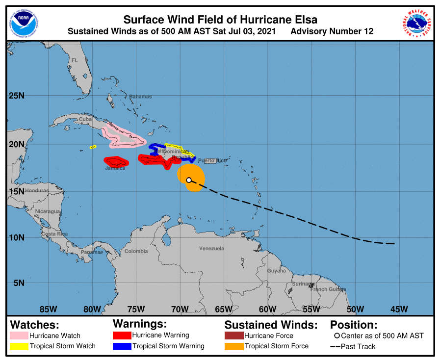
Matt on the Tropics
Tropical Updates
  • Home
  • About
  • Archive (pre-blog)
  • Contact
  • Weather Links
  • Weather Trivia

tropical update tuesday 8-10-21, 8 am

8/10/2021

 
Good morning.

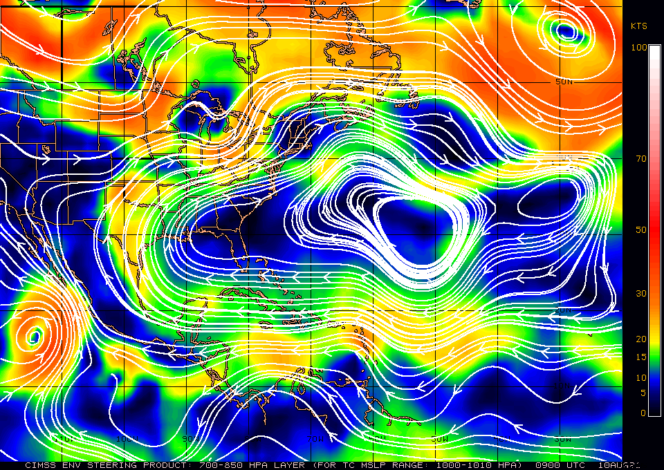
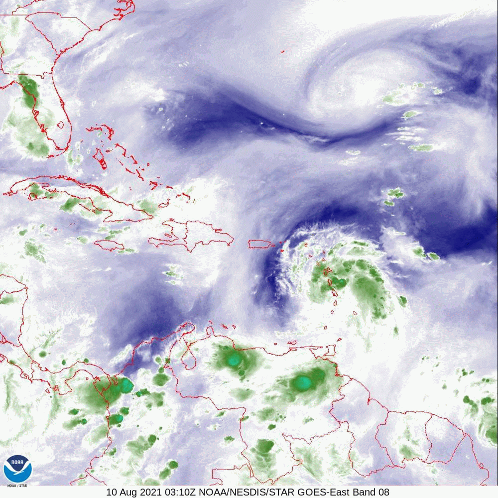
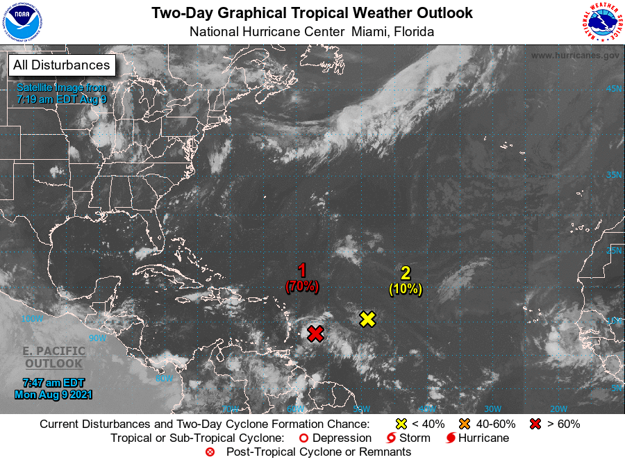
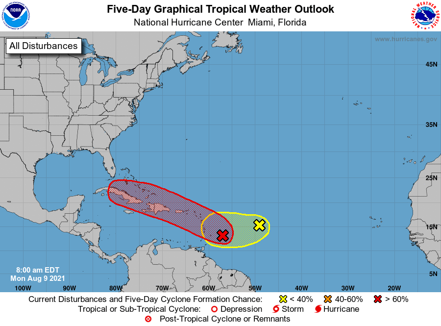
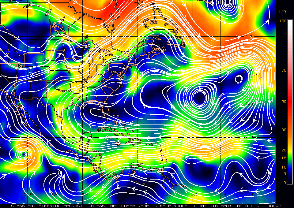
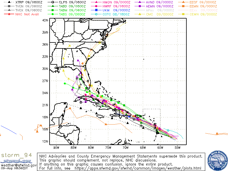
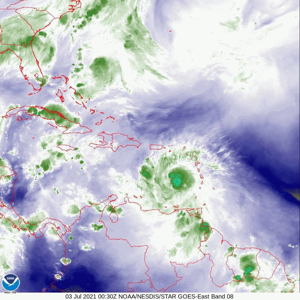
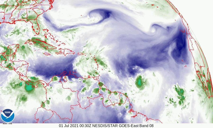
The NHC has named the disturbance discussed yesterday Potential Tropical Cyclone #6. If you look at the water vapor loop below you can see that it is becoming better organized and will likely become TS Fred later today or tonight. There are a couple of features to note on the water vapor loop. First is the upper level low to its north, south of Bermuda. Second is a smaller upper level low over Andros Island which appears to be moving slowly westward. Also note SW shear over Cuba. Just note these for now, they may or may not have an impact on where Fred goes later. The Hurricane Hunters will be flying into the system later today to better evaluate it.
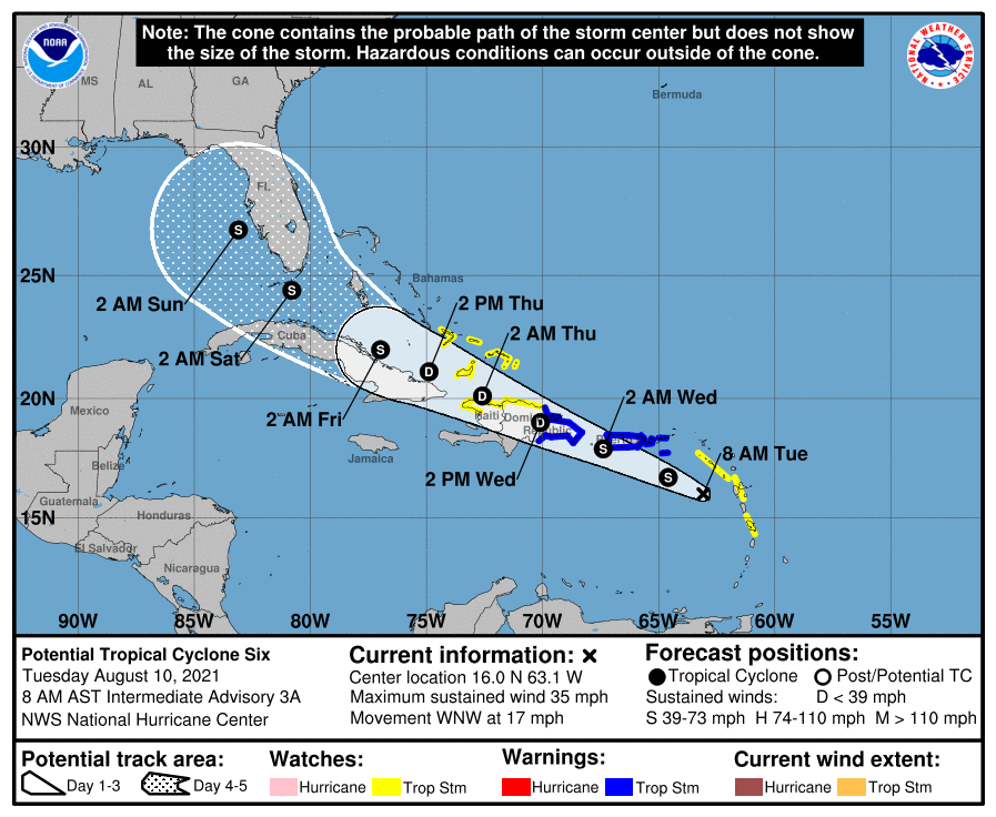
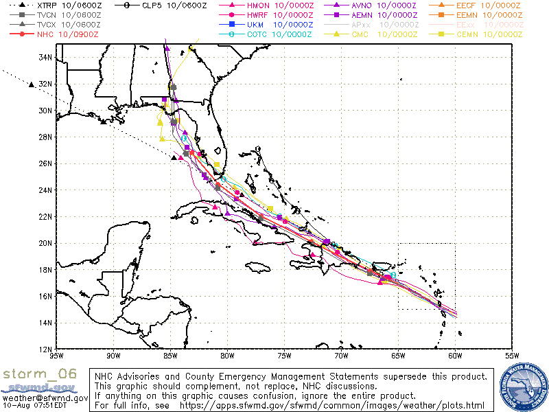
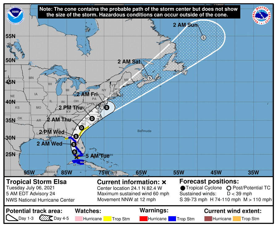
It is currently headed toward Hispaniola. After that a track over or along the northern coast of Cuba followed by a NW turn into the Gulf of Mexico toward the northern Gulf Coast is anticipated. It is still too early to make an accurate forecast, especially as a circulation center has not been identified. In addition if it crosses Hispaniola reformation of the eye could happen in an unexpected location which could alter its course.

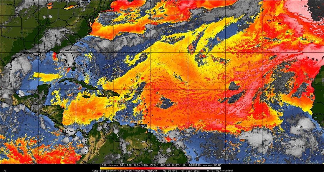
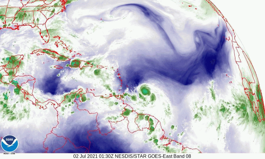
If you look at the SAL Analysis below you can see that there is dry air ahead of the system which will be moving along with it which should slow development. You will also notice that compared to the SAL images in July, the dry air and dust has become eroded and is appearing moth eaten along its southern borders. This is due to the gradual moistening of the air by tropical systems as they move eastward off of Africa. This trend should continue making development of future systems more likely.
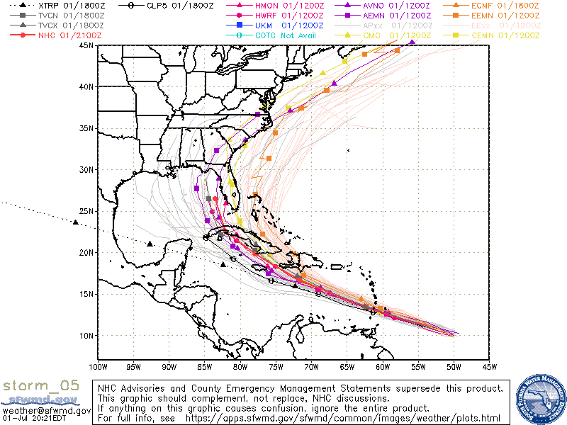
If you look at the IR image of Africa below you can see the pipeline of systems starting to line up over tropical Africa. The Cape Verde Season is starting. The systems that come off the African Coast between 10 and 12 degrees latitude are the ones that we in Florida need to watch the most. 

I'll be watching.

Until next time, 
​
                                              Matt.


Picture
Picture
Picture
Picture
Picture
Picture
Picture

tropical update monday 8-9-21, 9 am

8/9/2021

 
Good morning.

I'm writing about an area of disturbed weather east of the Lesser Antilles which is likely to become TS Fred in the next day or two. It is too early to make an accurate forecast as a center of circulation still does not exist however in looking at the Surface Map below I would anticipate that it would be steered toward Cuba or the Florida Straits and then the Northern Gulf of Mexico. Hopefully high pressure will remain over Florida and protect it. I'll be watching, but at present, I am not overly concerned.

Until next time.

                                                    Matt.

Picture
Picture
Picture
Picture

tropical update wednesday 7-7-21, 6:30 am

7/7/2021

 
Good morning.

TS Elsa is currently just west of Cedar Key FL and should be making landfall in the Big Bend of Florida this morning. Elsa briefly regained hurricane status yesterday evening however due to shear, dry air entrapment, its proximity to land and the shallow waters of the Gulf it has weakened. The NHC put peak wind generously at 65 mph at 5 am despite a central pressure of 1004 mbs. It will most likely come in as a 50-60 mph tropical storm. The main effects will and have been heavy rainfall along the West Coast of Florida.
If you look at the radar image below you will see that there is little weather on the west side of the storm. Once ashore it should weaken fairly quickly being a weak system to begin with.

This will be my last update on Elsa. Fortunately another miss for SE Florida.

Until next time,

                                            Matt.

​
Picture
Picture
Picture
Picture
Picture

tropical update tuesday 7-6-21, 6 am

7/6/2021

 
Good morning.

At 5 am TS Elsa was located in the vicinity of the Dry Tortugas and was moving NNW @ 12 mph. It is currently located about 20 miles to the east of where the NHC had anticipated it to be at this time. As a result the models and their track have shifted eastward. The NHC is now forecasting landfall about 40 miles to the east of where they had it yesterday and it is currently pretty much in line with my track from yesterday. My track has not changed.

If you look at the wind shear analysis below you can see that Elsa has around 25-30 knots of shear over it. This will slow development though there is a possibility that it could have winds near 75 mph at landfall tomorrow. 
If you look at the water vapor loop below you will see that Elsa appears very ragged, having been disrupted by its course across Cuba with little weather near its center of circulation. The upper level low remains, now over Louisiana. If you look at the Florida radar below you can see it starting to move up through the Florida Straits. Its center is on the west side of the rain mass which is currently spreading across the Lower and Middle Florida Keys.

Overall not much has changed and my forecast from yesterday still holds. With a moist S to SW flow over South Florida expect scattered rain showers today, especially this afternoon.

My best to all.

Until next time,

                                                Matt.


Picture
Picture
Picture
Picture
Picture
Picture
Picture

tropical update Monday 7-5-21,  7 am

7/5/2021

 
Good morning. 

At 5 am TS Elsa was located at 21.0 N & 79.9 W and was moving NW @ 14 mph with peak winds of 65 mph and a barometric pressure of 1004 mbs (again note this is relatively very high). It is currently due south of Miami, FL. Elsa is currently south and west of where the NHC had projected it to be at this time yesterday. In light of this the models have shifted further west and Elsa is now projected to pass near the Dry Tortugas tomorrow and being at its closest approach to SE Florida tomorrow afternoon. On the current NHC track it would pass around 200 miles to the west of the Miami area.
Elsa is currently a very compact storm with tropical storm force winds extending only 60 miles from the center. When it is west of South Florida the wind field is forecast to extend 90 miles. In light of this SE Florida will likely only see winds into the 20s with a few showers. Some rain but probably not a lot.

If you look at the Water Vapor Loop below you will notice a few features. First an upper level low just south of Louisiana, next a frontal boundary across southern Georgia, now drifting slightly north and TS Elsa south of Central Cuba slowly moving NW. My current track takes Elsa just north of the Isle of Pine crossing Western Cuba then tracking NW, then N, then NNE into the Big Bend area of Florida. Note the current model consensus takes it into the Panama City area. The official NHC track is east of that and I agree. Due to the upper level low in the northern Gulf of Mexico a slight deflection to the NE would be expected late in the forecast period. My current projection for landfall is between Homosassa Springs and Cedar Key centered around Waccasassa Bay Preserve State Park. The NHC track is a little west of that.

Fortunately this is not a strong system. Hopefully it will remain that way.

Until next time,

                                                        Matt.

PS. If you look at the Saharan Air layer Analysis below you can see that there has been a significant invasion of dry Saharan air and dust into the Tropical Atlantic. There must have been some big dust storms. The Tropics will probably be quiet for at least the next week or two.


Picture
Picture
Picture
Picture
Picture
Picture

Tropical update Sunday 7-4-21, 5:30 am

7/4/2021

 
Good morning.

With regards to Elsa there has been an interesting development overnight. When the Hurricane Hunters were in it early this morning they discovered that a new center had formed under the area of deepest convection well east of the previous center. The old center basically uncoupled and ran away from it. The net effect of this is Elsa is now centered south and east of the prior projections and is currently right along the NE coast of Jamaica. Because of this it is now better organized and moving slower and it could temporarily regain hurricane strength later today. Due to its more southerly location a track across eastern Cuba is much less likely and confidence is increasing in the current NHC track. After it crosses Central Cuba it should weaken, and increased shear north of Cuba will hamper re-intensification. The NHC is currently calling for it to be a  50-60 mph storm when it passes just west of Key West and at its closest approach to SE Florida. On the current track it would bring it around 150 miles west of the Miami area. Tropical storm force winds are projected to extend only 90-100 miles to the NE of the center that time. If the current track hold SE Florida would not experience storm conditions. Probably peak winds in the 30s in a few squalls and showers.

I'll write again tomorrow morning sooner if things should change,

                                                            Matt.

​
Picture
Picture
Picture
Picture
Picture

tropical update saturday, 7-3-21, 5:30 am

7/3/2021

 
Good morning.

At 5 am H. Elsa was located at 16.2 N and 69.0 W with a minimum pressure of 998 mbs and was moving WNW @ 31 mph with peak winds of 75 mph (which is probably generous. You usually need a pressure of around 983 mbs to see that, see Weather Trivia on this site). Due to its rapid forward motion Elsa has become uncoupled and has weakened some with its center to the NW of most of its weather which is displaced to the SE.
On its present track it will most likely just nip the southern tip of Hispaniola. With its rapid speed and inertia it will be hard for it to change direction quickly. 
If you look at the models there are two main solutions emerging. The first which is the NHC's track continues Elsa on its present course passing along the southern coast of Cuba before crossing central Cuba and entering the eastern Gulf of Mexico. The cold front mentioned yesterday is now across northern Florida, where it will probably stall, would then direct it into the West Coast of Florida. The second solution takes Elsa into Eastern Cuba, where with the center displaced to the NW of its weather, it could cross eastern Cuba, or the eye could reform along the NE coast of Cuba. If this were to occur a track east of Florida toward Grand Bahama would be more likely. Due to anticipated land interactions Elsa is forecast to be a tropical storm when in the vicinity of Florida or the Bahamas. Due to significant inertia I would favor the first solution ? 60% probability, ? 40% for the later. Just where it is around this time tomorrow will be the key.
On the present NHC track SE Florida would receive peak winds in the 30s-40s with a lot of rain. If it takes the eastern track 20s-30s with little rain. If it should go in between and hit South Florida directly 60s-70s  (less likely ? 10% chance) and lots of rain . 

I'll write again tomorrow, sooner if needed.

Until next time,
                                         
​                                                       Matt.


Picture
Picture
Picture
Picture
Picture
Picture
Picture

tropical update Friday 7-2-21, 6 am

7/2/2021

 
Good morning.

Since yesterday a few interesting things have developed regarding Elsa.
​
Elsa now moving quickly to the WNW at 28 mph and is a little ahead of yesterday's NHC forecast but is currently on their track.

If you look at the Water Vapor Loop below you will notice a few things. First is that Elsa has become better organized and is moving steadily and symmetrically to the WNW. Next the upper level low is still in the central Gulf of Mexico. Next and most importantly see a cold front across the SE US pushing slowly to the SE. This will be a key factor in determining where Elsa will go.
If you look at the Models from last night, which have not changed this morning, you will see that they are all over the place. Currently ALL tracks for Elsa are low confidence tracks. The NHC is currently using the consensus of the European models for their track however do not be surprised if a dramatic shift should occur. If you look at the Surface Map below you will notice when compared to yesterday's, the High pressure in the Western Atlantic has shifted a little eastward and the isobars over Cuba, the Yucatan Channel and Florida have widened. This is in response the approaching cold front across the SE US. It is not stationary and if it should get far enough south a further deflection to the east is possible. Note these shifts are temporary and timing will be key.

If you look at the isobar that Elsa is on, on the close up Surface Map, you will see that it take it into Hispaniola. Note this is north of the NHC track. A key for South Florida will be if Elsa tracks south of Hispaniola, vs through it and how much land interactions occur between it and Hispaniola and Cuba. If it should track across Hispaniola and emerge on its north coast a track thru the Bahamas and east of Florida and missing the US would become more likely. If it moves south of Hispaniola and Cuba a track into the West Coast of Florida would become more likely. If it should get south of Cuba it should slow dramatically and if that happens it will give time for the environmental conditions to change. This is what is leading to the marked uncertainty in Elsa's forecast.

Short term as stated above the key will be just what happens tomorrow afternoon and night with regards to Elsa and Hispaniola.

Until next time,

                                                Matt.

​
Picture
Picture
Picture
Picture
Picture
Picture
Picture

Thursday 7-1-21, 8 pm Model run

7/1/2021

 
Good evening.

I just wanted to share the latest model run. Pretty amazing. Look at the spread. Its almost 1400 miles wide! I'll explain why and what may happen with Elsa tomorrow morning. 

Matt.
​
Picture

Tropical Update Thursday 7-1-21, 5:30 am

7/1/2021

 
Good morning.

Early this morning Potential Tropical Cyclone #5 became better organized and the NHC located a center of circulation and named it Tropical Storm Elsa. If you look at the Surface Map below you will see that the isobar that it is on takes it to the northern Yucatan Peninsula. This is not likely where it will go. 
If you look at the water vapor loop below you will notice a couple of interesting features. First Elsa is south and west of where they anticipated it to be yesterday and it appears to be moving just south of west, not along the current NHC track. Next note an upper level low spinning counter clockwise over the central Gulf of  Mexico. IF this feature should persist it would tend to turn Elsa to the NW as it approaches the Western Caribbean. My current track is south and west of the NHC's and takes Elsa either through the eastern Yucatan Channel or into the Isle of Pines and the western tip of Cuba. Louisiana or Mississippi appear to be at highest risk at present, however it is still very early in the forecast track and some changes are likely.

I'll be watching and will write another post early tomorrow morning. Sooner if needed.

Until then,

​                                      Matt.

​
Picture
Picture
Picture
Picture
<<Previous
Forward>>

    Categories

    All
    Preseason Update