Matt on the Tropics
Tropical Updates
  • Home
  • About
  • Archive (pre-blog)
  • Contact
  • Weather Links
  • Weather Trivia

Tropical Update Thursday, 8-29-19, 7:30 am

8/29/2019

 
Good morning,

Cassie here. My dad isn't available to write an update this morning, so I'll do my best to give you a run-down of the forecast conditions for Dorian.

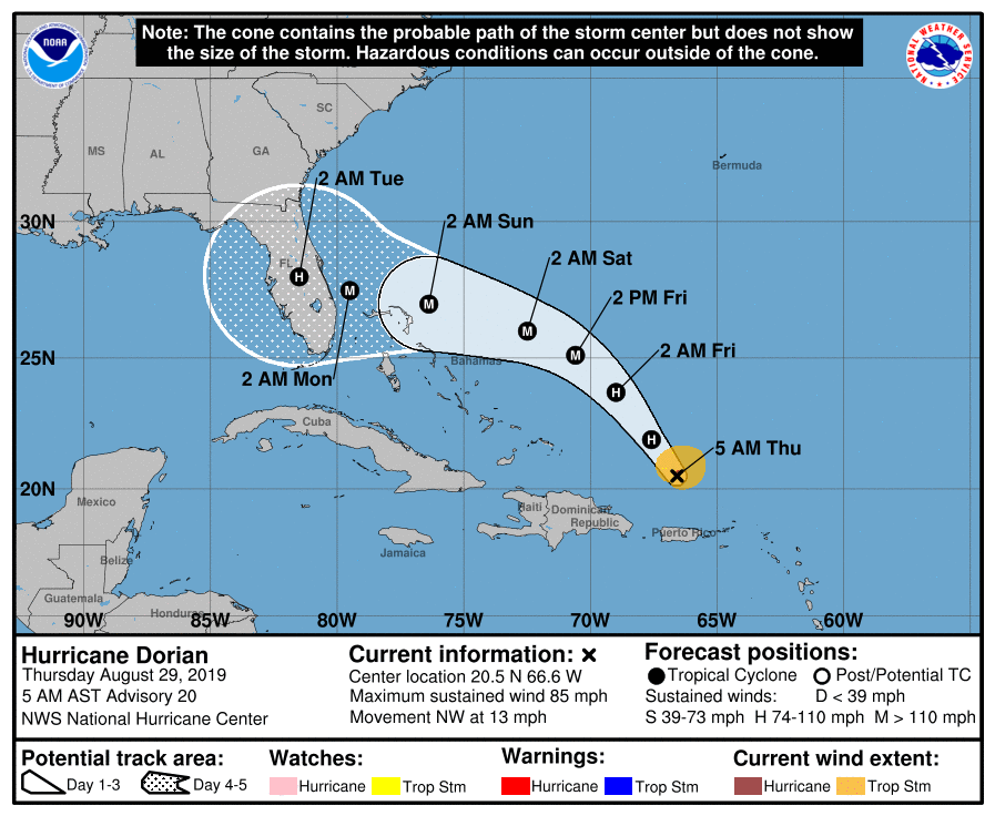
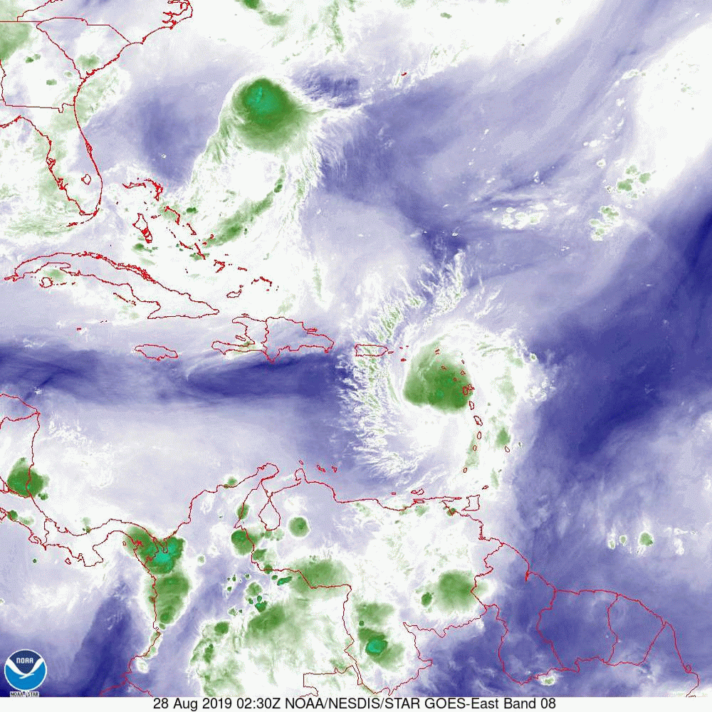
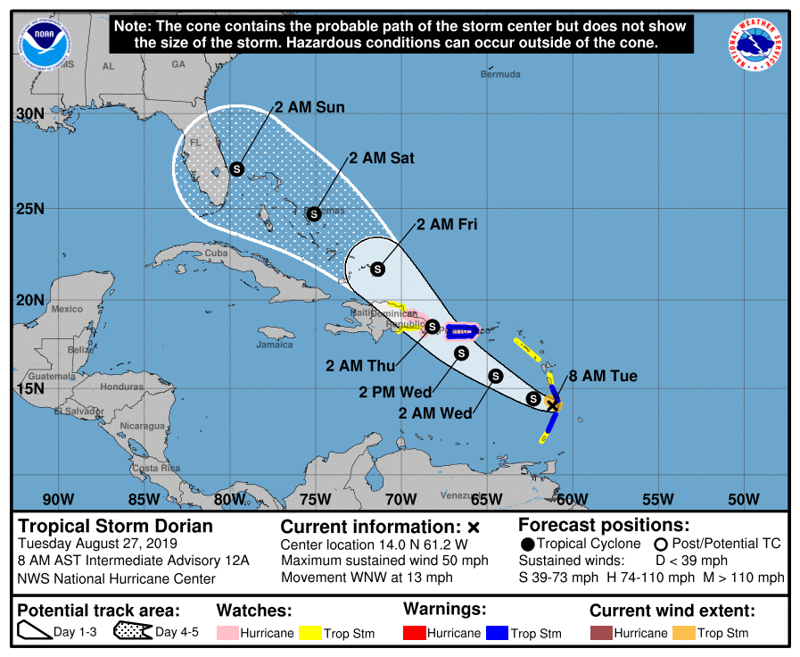
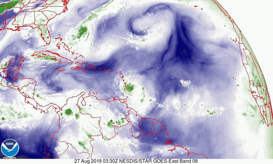
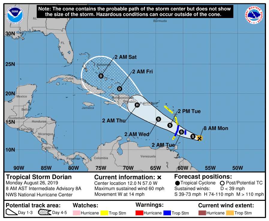
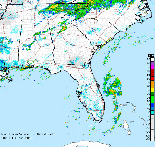
Dorian is currently located north of Puerto Rico at 20.5 N and 66.6 W, and continues to stay on the northeastern edge of the NHC forecast so far. The NHC has made a few updates to their track overnight, most notably slowing down the storm and slightly widening the cone.

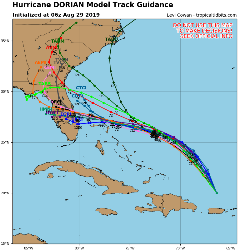
Ultimately, it's still too soon to predict precisely where the storm will make landfall. There is relatively high confidence in the storm's track for the next 48 hours, and then much more uncertainty. The ultimate location of landfall will depend on what happens to the pressure ridge currently over northern Florida, and it's still too soon to tell how it will behave. If the ridge weakens, the storm would take a more northerly track, and if the ridge strengthens, the storm could go further south. If you look at the models, you'll see a wide spread and divergence depending on what they assume about this ridge.

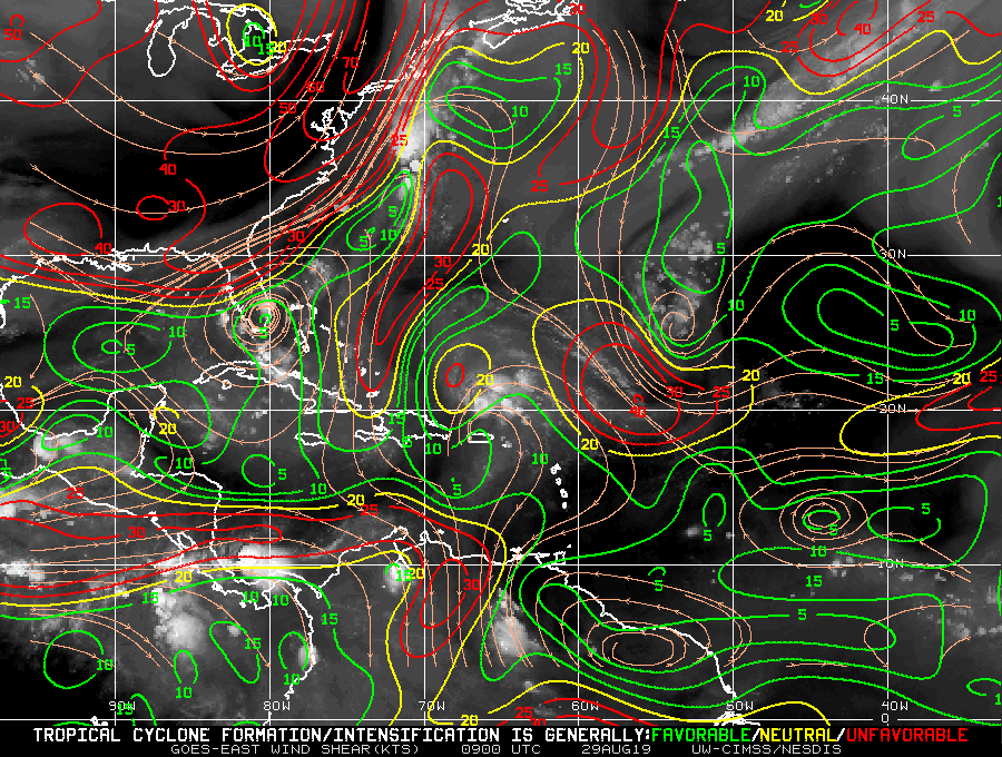
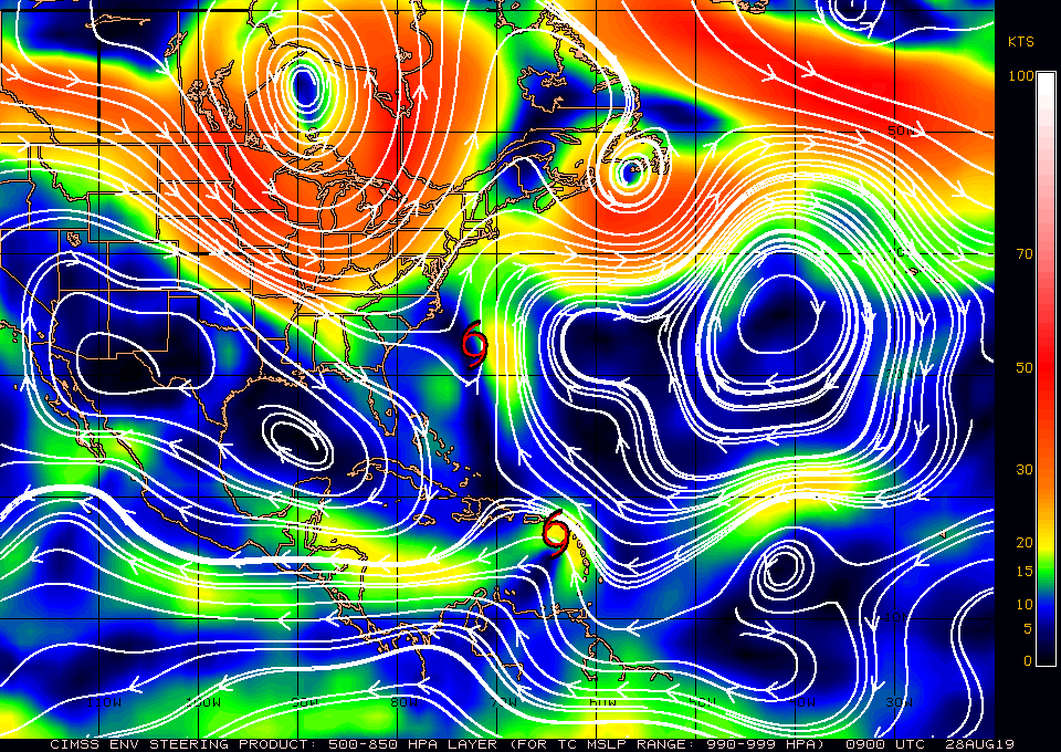
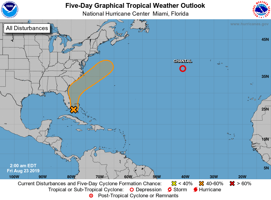
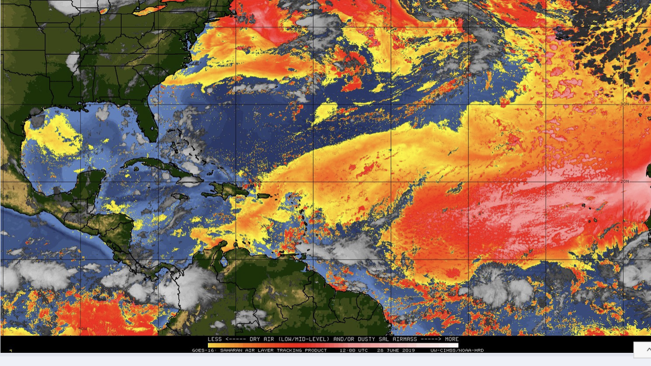
As for intensity, Dorian weakened slightly overnight and will be passing through some small pockets of shear over the next couple of days but also over warm waters, and is projected to strengthen. You can see the wind shear in the third image (where you can also see the ridge I mention above).

My dad will post additional insights and clarifications later this afternoon.

Take care,
Cassie

Picture
Picture
Picture

tropical update Wednesday 8-28-19, 7:30 am

8/28/2019

 
Good morning.

​With regards to Dorian several things have changed since yesterday. First and most important is that it continues to track N and E of the NHC's forecast track. If you look below I have attached several graphics. First the current NHC forecast track, second a current surface map, third the current water vapor loop, fourth current live Puerto Rico Radar and lastly the numerous Ensemble Models. If you look at the water vapor loop you will notice several features. First is Erin spinning off the SE US coast, it is forecast to move out to sea, second is Dorian in the extreme NE Caribbean Sea. Notice it continues to be moving east of the NHC's track and will likely pass just east of Puerto Rico today. The next thing to notice is an upper level low right between Erin and Dorian. This is the wild card and will likely influence just where Dorian goes. The SW upper level flow on Dorian's side of it is what is drawing Dorian further east. Conversely once it gets to the other side of it it will tend to push it further west. Right now it appears fairly stationary though that is  likely to change. If Dorian moves directly over it it would likely weaken it significantly, if it moves to the NE it could actually enhance it. The behavior of upper level lows can be very hard to predict, thus it being the wild card. We'll have to see. If you look at the Surface Map you will notice a large open area between isobars north of Hispaniola bordered to its north by the area between roughly Daytona and southern South Carolina. This is currently the window at which Dorian is heading. This will likely change some but the risk to South Florida continues to lessen. Note due to the more eastern track it will take longer for Dorian to approach the US and the NHC is currently forecasting it to a Cat 2 with landfall Monday. Once it gets to the other side of the upper level low shear will decrease and further intensification will be possible. In addition the longer it takes the more likely that conditions will change and there is still the possibility of it staying just off shore and tracking NE. If you look at the models there is huge divergence however with the continuing eastward trend the more northern tracks will become more likely.
Interests from Titusville to the Carolinas need to keep a close eye on this one as a longer course over warm water and the lack of significant land interaction with Puerto Rico or Hispaniola, could lead to an even stronger system.

I or possibly my daughter Cassie, who is brilliant and apprenticing with me, will write again tomorrow morning.

Matt.


Picture
Picture
Picture
Picture
Picture

tropical update Tuesday 8-27-19 8:30 am

8/27/2019

 
Good morning.

In reviewing the data on TS Dorian this morning a few things are to be noticed. First it is N and E of where the NHC had forecast it to be yesterday at this time. This is good news. This makes a move into the central Caribbean unlikely and reduces the risk of a South Florida landfall. In addition it has weakened. If you look at the second diagram, Saharan Air layer, you can see that it continues to be surrounded by dry air. This will limit development until it gets into the Bahamas. If you look at the wind Shear Analysis, 3rd diagram, you will see that other than a small window just north of Puerto Rico, there is a lot of hostile environment in front of it.
Lastly if you look at the water vapor loop, bottom diagram you will notice several features. First is TD #6 under going significant NE shear east of Florida (it will move out to sea), Dorian entering the NE Caribbean starting to encounter SW shear, the small blue window of low shear just north of Puerto Rico and lastly a cold front approaching the SE US. We currently have high pressure centered over South Florida, this should help to protect the southern 1/2 of the state. The approaching frontal system would tend to deflect the storm to the NE however high pressure is forecast to build over the Atlantic which could push Dorian toward central-north Florida or the Carolinas. It is still way too early to say. Steering forces remain weak over the Bahamas which will lead to greater uncertainty in the overall forecast.
Right now the risk to South Florida is low.
Dorian remains a small system and will be vulnerable to the adverse conditions in front of it. The NHC is currently not forecasting it to become a hurricane, though that could change. This is unlikely to become a major hurricane for anyone.

I will write again tomorrow. The possibility of further weakening or even dissipation are also possible so I would not get too hyped up about this one at this time.

Matt.
​
Picture
Picture
Picture
Picture

tropical update monday 8-26-19, 7 am

8/26/2019

 
Good morning.

I am writing this morning about TS Dorian which should enter the eastern Caribbean Sea tomorrow.
Dorian is a very small system with storm force winds extending no further than 40 n miles from the center. Note small system are very vulnerable to adverse conditions and can easily dissipate, and likewise intensify when conditions are just right (but they aren't). Notice it is surrounded by dry air. (SAL, second diagram below, yellows, oranges and reds are dry air.) The NHC is currently forecasting it to cross Hispaniola with weakening as it approaches due to increasing shear as it approaches and land interactions. On the current NHC track it would likely miss the US. However in looking at the Surface Map below steering forces will be weak as it enters the northern Caribbean and a track closer to Jamaica could be a concern for Florida IF it can survive the dry air and shear. We'll see.

Elsewhere the next potential threat is a tropical wave over east central Africa which is probably a week away from making it to the Atlantic and over 2 weeks away from anyone. I'll keep an eye on it. 
The area of low pressure which I wrote about on Friday may still develop, however it will not pose a threat to the US.

I'll keep you posted. No cause for alarm at this time.

Matt.
​
Picture
Picture
Picture

tropical update Friday 8-23-19, 7 am

8/23/2019

 
Good morning. 

I'm writing this morning about a weak area of low pressure currently located midway between Andros Island and Miami. If you look at local radar you can see it. It is currently moving slowly northward. It is in a low shear environment and the NHC is giving it a 60% chance of tropical development over the next 5 days. Most of it's associated weather is NE of the center. The good news is that it will probably miss the US. Sea surface temperatures under it are quite warm and I believe development is likely but like Chantal it will probably only be an issue for mariners. South Florida will see some passing showers today in association with it. It should move out of South Florida waters by tomorrow.

Elsewhere all remains quiet with abundant Saharan dust and dry air over much of the tropical Atlantic, though some signs of its erosion are now evident. In a couple of weeks things may be different.

I'll keep you posted.

Have a great weekend,                  

Matt.
​
Picture

Tropical update Friday 8-9-19, 7:30 am

8/9/2019

 
Good morning.

The National Weather Service/ NOAA / NHC revised their season forecast yesterday due to the fairly abrupt end of El Nino conditions. We currently have a neutral-ENSO (El Nino-Southern Oscillation). El Ninos are characterized by cooler, wetter winters and an increase in shear across the Caribbean and western Atlantic. If you look at the Wind Shear Analysis below you will see lots of green. Basically green is favorable for tropical development, yellow border line and red hostile for development. A week ago (and the entire first half of the year) this looked very different with lots of red.
The good news is that there is nothing at all in the tropics right now. In addition note the abundant dry air and Saharan Dust over the eastern and central Atlantic. This will hinder the development of anything coming off of Africa for some time however each wave that passes will erode a little bit of this layer and in a month we may be looking at a different picture.

This does NOT mean that we will get a storm. Where any storm goes depends on the unique environment conditions that exist at the time it is out there and that is something we cannot predict at this time. If you look at the bottom chart, Sea Surface Temperatures you will see that Gulf of Mexico remains the area of greatest risk this season. NOAA is predicting a 45% chance of an above average system and a 55% chance of an average or below average season. Due to the abundant dust my guess would still go for average, however the absolute number of storms is not what counts. It's weather you get one or not. And no one can predict that.

I'll let you know as things evolve though I continue to suspect a slow start to the season with an increase on activity late, (Sept-Oct).

Until next time,

Matt.

Picture
Picture
Picture

Tropical Update Friday 8-2-19, 7:30 am

8/2/2019

 
Hello all.

Just writing a quick post assessing the current conditions in the tropics. In a nut shell, so far so good.

Remnants of a weak tropical wave are over and just east of South Florida now, will bring increased chances of rain today and tomorrow for South Florida.

The NHC is giving a tropical wave over the central Atlantic a 50% chance of development over the next 5 days. Dry air to its north and increasing shear to its N and W will hamper significant development. In addition an upper level low over the north central Gulf of Mexico should produce an upper level SW flow in 2 -3 days which should prevent whatever is left of it from affecting the state of Florida.

The only area that  I see of concern is a robust wave over central Africa which is probably at least 2 weeks away from the US. We'll have to see what conditions prevail at that time however abundant Saharan dust over the eastern and central Atlantic will hamper anything coming off of Africa for some time.
 
Tropical Storms Flossie and Erick will both miss Hawaii.

I'll let you know if things should change but the US probably has at least 2 weeks off without concern from the tropics.

Have a great summer.

Matt.

tropical update tuesday 7-23-19, 8:30 am

7/23/2019

 
Good morning.

TD #3 formed this morning just off the coast of Central Florida. It may become a minimal tropical storm later today before dissipating tomorrow as shear from an approaching front to the north and west will disrupt it. The NHC says it is moving N @ 12 however if you look at radar images below you can see that a NE move has already started. In light of this it will probably miss the Carolinas. Even if it should brush them there won't be much left of it.  Elsewhere a stalled frontal system along the northern Gulf of Mexico will likely bring rain and thunderstorms and possibly even a TD to the Florida Panhandle. There should not be enough time for anything significant to develop.

Until next time,

Matt.
​
Picture
Picture

Tropical Update Monday 7-22-19, 8 am

7/22/2019

 
Good morning.

I'm writing about an area of disturbed weather over the Central Bahamas.
The NHC is currently giving it a 30% chance of tropical development over the next 3 days. It is being caused by a trough of  low pressure which is currently in a low shear environment. It is currently drifting NW. On the Surface Map below it is the greeninsh area, As you can see upper level winds should steer it to the NW and eventually N and NW. A frontal system approaching from the west should increase the likelihood of that happening. It currently appears to posse greatest risk to the coastal Carolinas, > for North Carolina, though there is a decent chance it could miss them as well, if it should develop. It currently appears that it should miss the state of Florida.

Elsewhere all is quiet. I'll let you know if things should change,

​Matt.

Picture
Picture

Tropical update Friday 6-28-19, 11:15

6/28/2019

 
Good morning.

I've been receiving a lot of questions about, "What's going on in the tropics?"
The answer simply is nothing.

We currently have copious amounts of dry air and Saharan dust over the eastern and central tropical Atlantic (see Saharan Air-layer Analysis - SAL below), abundant shear across the Caribbean and western tropical Atlantic and below average water temperatures over the far eastern tropical Atlantic. The combination of the above present highly unfavorable conditions for tropical development. In light of this it is very unlikely that we will see any development for probably at least 2 weeks. I'll write if things should change, but, so far so good.

Have a great 4th of July weekend,

Matt.
Picture
<<Previous
Forward>>

    Categories

    All
    Preseason Update