Matt on the Tropics
Tropical Updates
  • Home
  • About
  • Archive (pre-blog)
  • Contact
  • Weather Links
  • Weather Trivia

tropical update friday 6-3-22, 5 pm

6/3/2022

 
Good evening.

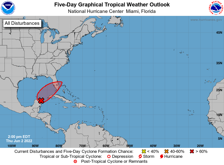
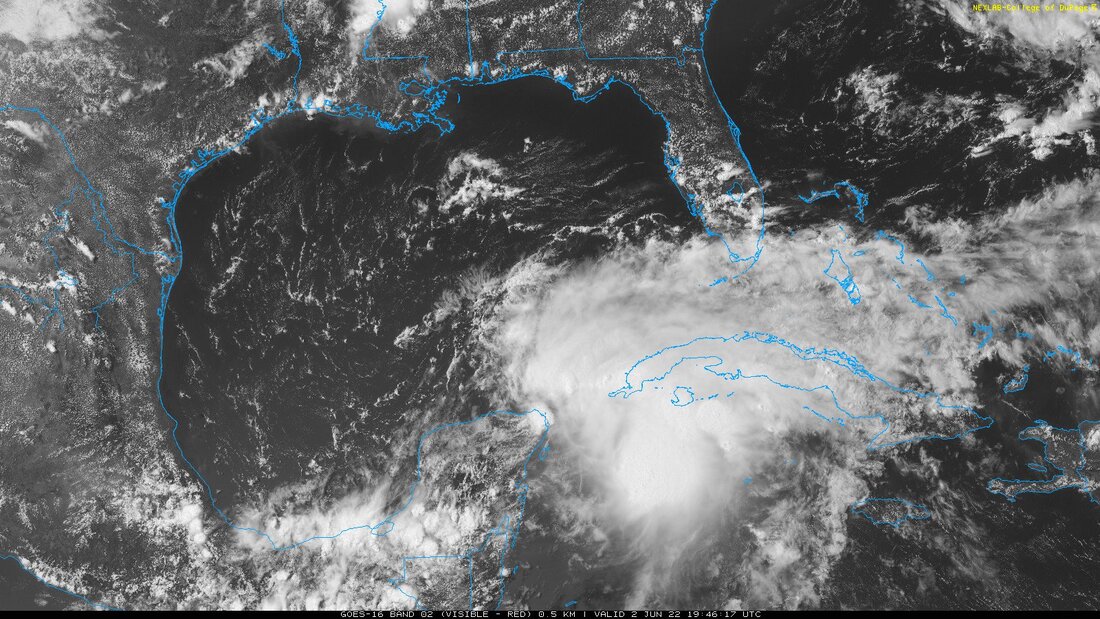
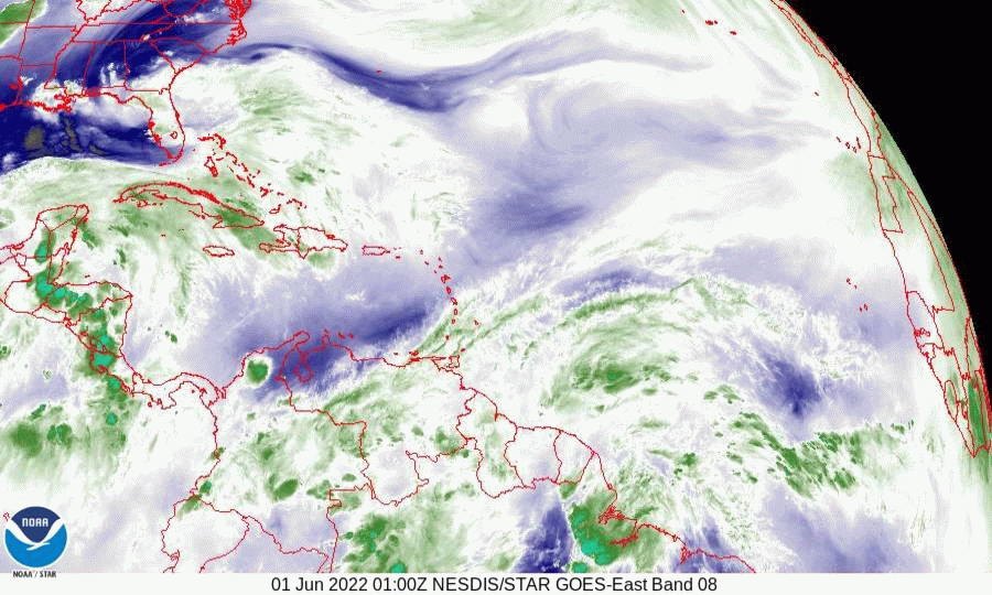
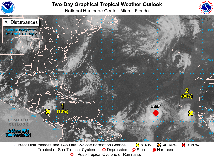
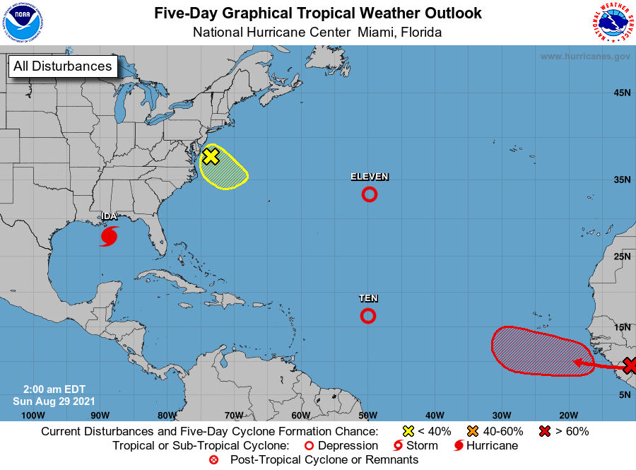
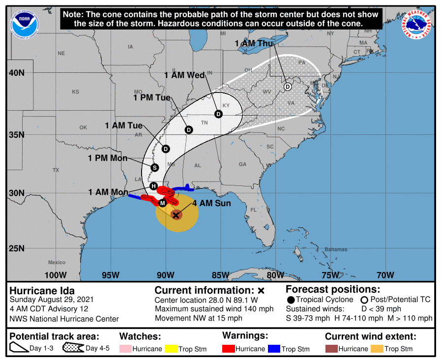
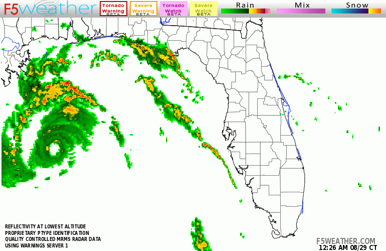
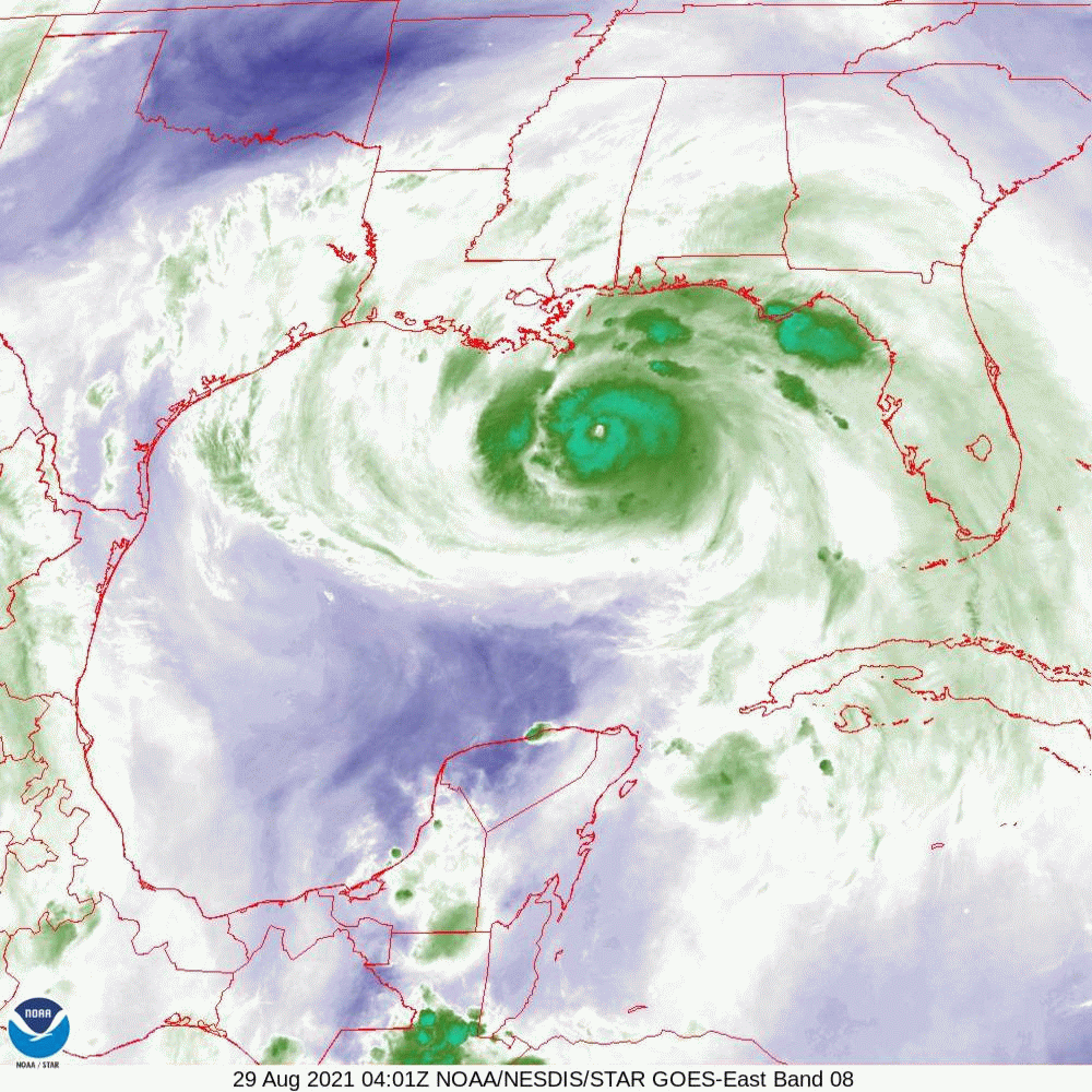
"Potential Tropical Cyclone #1" continues to head toward SW Florida. Hurricane Hunters were in the system recently and were still unable to find a discrete center of circulation nor any storm force winds. It remains a trough of low pressure with several vortices along it. Frankly it is irrelevant. This will be  a RAIN EVENT. It remains in a high shear environment and the estimated center remains just to the west of the western most convection. It rained a lot in South and Central Florida today however the real rain will begin tonight and last through Saturday afternoon. Rainfall estimates have been increased to 6-12" with some areas potentially receiving up to 20 inches. Currently the NHC is predicting it to be a 40-45 mph storm at land fall early tomorrow afternoon. As all the weather is east of the center, once it passes conditions will improve quickly. It will speed up as it approaches.

My estimates for location and winds for SE FL have not changes, winds 20s with gusts to 30s. The Fort Myers area remains at greatest risk however as it is a weak diffuse system all of SW Florida will receive similar weather. Heavy rain with wInds  in the 30s with gusts to 40s.

My best to all.

Until next time,
                                            Matt.

​
Picture
Picture

tropical update thursday 6-2-22, 4 pm

6/2/2022

 
Good afternoon.

Since yesterday's forecast nothing has changed. The NHC is giving the low pressure system currently over the NW Yucatan Peninsula an 80% chance of tropical development over the next 2 days. Due to high shear over the system all of the associated weather is displaced to the east of the low. This should help to slow development and should prevent it from becoming too strong.
The Ft. Myers area remains at highest risk though due to an anticipated weak system the weather should be fairly diffuse. For SE Florida winds in the 20s with gusts to 30s with 5-10+ inches of rain are anticipated. SW FL should have similar rainfall with higher winds.

I'll probably post again tomorrow afternoon. South Florida should expect a blustery and rainy Friday and Saturday.

Until next time,
                                                      Matt.


Picture
Picture
Picture

tropical update wednesday 6-1-22, 6 am

6/1/2022

 
Good morning.

Today marks the first day of the Atlantic hurricane season, which will run until November 30. Long-term averages for the number of named storms, hurricanes, and major hurricanes are 14, 7, and 3, respectively. The list of names for 2022 is as follows:

Alex, Bonnie, Colin, Danielle, Earl, Fiona, Gaston, Hermine, Ian, Julia, Karl, Lisa, Martin, Nicole, Owen  Paula, Richard, Shary, Tobias, Virginie and Walter .

I am writing about an area of disturbed weather over the Yucatan Peninsula and the NW Caribbean Sea. The NHC is currently giving it a 70% chance for a tropical depression to form within the next 5 days. There is currently an old frontal boundary in the region of lake Okeechobee which would tend to draw whatever weather that does develop towards SW Florida. Fortunately wind shear is very high over the Gulf of Mexico and even if it should develop it is unlikely to become more than a weak to medium strength tropical storm. Hurricane conditions would be very unlikely. As no center of circulation currently exists it would be very difficult to predict exactly where it would go at this time however the Ft Myers area currently appears to be at greatest risk. Whether or not tropical development occurs anticipate rain across South Florida the next few days greatest on Friday and Saturday.

I'll be following it and will keep you posted.

Until next time,

                                                    Matt.


Picture
Picture
Picture
Picture
Picture
Picture

Tropical update Wednesday 5-26-22, 8 am

5/25/2022

 
Good morning.

Just a quick statement referring to some interesting data / images.

Below first is the Gulf of Mexico (GOM) Loop Current which carries warm water from the Caribbean into the GOM then passes through the Florida Straits and becomes the Gulf Stream. You can see it well defined along with several warm water eddies in the western GOM.

Next is the Heat Content of the Western Caribbean and the GOM which is a combination of water temperatures and warm water to depths > 100 feet. It shows a huge amount of heat to great depths already (actually to over 300 feet) in the East Central GOM. This is more and further north than is usually seen this time of year.

Next is the Saharan Air layer Analysis. Like last year there have been a lot of dust storms over northern Africa this year with abundant dust and dry air extending over the Tropical and Western Atlantic. (This will make tropical development in these areas difficult.)

The bottom line. The Gulf of Mexico and the Caribbean will be the areas to watch June thru November. By late August / September the SAL should be mitigated and we'll be re-evaluating the Atlantic (and the time in between).

Until next time.

                                                   Matt.


Picture
Picture
Picture

Preseason Tropical Update 4-26-22

4/25/2022

 
Good morning.

2022 is currently forecast to be an above average hurricane season in the Atlantic Basin. La Nina conditions returned in September last year, however thanks to Sam the 2021 season ended quietly. Whereas the NWS had expected the current La Nina to end by early summer, the past month has actually seen a further drop in water temperatures in the eastern Pacific. It is now looking more likely the the present La Nina will persist through most if not all of the 2022 Hurricane Season. La Ninas are associated with reduced shear across the Caribbean and Western Atlantic and subsequently are usually associated with more tropical storms and hurricanes. So far the warmest waters are in the Gulf of Mexico and the Western Atlantic. Therefore the areas of greatest risk this year appear to be the north central and eastern Gulf of Mexico, Puerto Rico and the US Virgin Islands, the Bahamas and SE Florida and the Carolinas. It does NOT mean all of these areas will have storms this years. Just greater than average risk. For SE Florida for example, we see hurricane conditions on average 1 in 7 years or 14% risk. Even if the risk was 20%, it is still unlikely that any specific area will have a storm.

2021 was an extremely dry year at my house with total rainfall of only 25.45" well below my 32 year running average of 66.79". I believe this was a very localized phenomenon as other parts of South Florida were not nearly as dry. As opposed to 2020 we had no rain events. (See Preseason Forecast from last year 4-23-21.)

Remember the absolute number of storms is not what is important, its where they go. Last year was on overall active year however most went out to sea. 

Hopefully this year they all will.

With best wishes to all,

                                                                     Matt.

Tropical Update 12-1-21, TGFS - season recap

12/1/2021

 
Thank God For Sam. (TGFS)

Today marks the official end of the 2021 Hurricane Season and TGFS.

2021 was overall an active season with regards to the absolute number of storms however aside from Hurricane Ida it was a good year for the US in general. As suspected in my 4-23-21 Preseason Update Florida and the Northern and Eastern Gulf Coasts saw the bulk of the activity.
On 7/7/21 TS Elsa made landfall along the Big Bend area of Florida as a 65 mph TS.
On 8/16/21 TS Fred made landfall on the Florida Panhandle near Panama City as a 50 mph TS.
The only significant storm was Hurricane Ida which made landfall along the Louisiana coast passing over Houma, LA as a Cat 4 hurricane causing significant damage. It fortunately passed far enough west of NOLA to spare it from the worst of it.

As forecast La Nina conditions returned in September, which are usually associated with increased storm activity, however thanks to Sam, an unusually slow moving, long lived major hurricane which slowly moved out to sea not making any landfall, a huge amount of heat was removed out of a key portion of the tropical Atlantic in September effectively wiping out all of the systems which followed in its wake. Subsequently instead of a busy finish, the 2021 season ended quietly with no significant activity after Sam. Never knock a White Knight.

Wishing everyone a great Holiday Season and New Years,

                                                       Matt.


tropical update wednesday 9-29-21, 8 am

9/29/2021

 
Good morning.

Just a quick update. Everything looks good for the time being.

There are several systems out there however none currently pose a threat to the US. They are all moving out to sea. Hurricane Sam remains a major hurricane and has been doing a great job in removing a huge amount of heat from a broad swath of the Tropical Atlantic moving very slowly over the past week, producing significant up-welling and cooling the waters under it. Each storm does its part in reducing the potential of future storms. Having all of these out there, moving away, is a good thing and better than if they didn't exist at all. High pressure remains over Florida and has been protecting the state.

Until next time,

                                            Matt.


Picture
Picture
Picture
Picture

tropical update Tuesday 9-14-21, 3:30 pm

9/14/2021

 
Good afternoon.

Just a quick note. The tropical wave over Africa that I spoke about last week has emerged off the coast and the NHC is giving it a 70% chance of development. Almost all of the current models take it out to sea, missing the US. It is however early and its pretty far south, around 10.5 degrees N, so until it forms and actually starts moving to the WNW we'll need to keep an eye on it. Saharan dust and dry air to its west should help to slow development.

On the good news front if you look at the IR of Africa below, it appears that the Cape Verde season is winding down over Africa and the Inter-Tropical Convergence Zone is starting to drift southward. Once it gets south of around 8 degrees the Cape Verde season usually ends and we'll need to shift our attention to the Western Caribbean Sea and the Gulf of Mexico. If you look at the Wind Shear Analysis below you will notice high shear, almost 60 knots, over the entire state of Florida. This should protect the state for at least the next several days, hopefully longer.

If you look at Sea Surface Temps, bottom diagram you will see 2 pockets of hot water left. One in the Western Gulf of Mexico which Nicholas has taped into and will hopefully remove and one over the Bahamas where a disturbance is currently located which should drift north and hopefully take some of that heat with it. It's amazing how these system will find the warm water.

Looking okay for now.

Until next time,

                                                                Matt.

​
Picture
Picture
Picture
Picture
Picture
Picture

tropical update thursday 9-2-21, 6 pm

9/2/2021


Good evening.

Just a quick update on the tropics.

So far so good.

There are a few systems out there but currently none pose a threat to Florida. Hurricane Larry is forecast to move out to sea and potentially threaten Bermuda. The system behind it should follow in its wake on a similar course. The area which we'll need to watch is currently over central tropical Africa, the large red blob on the IR of Africa. It should emerge off the coast in around  5 days.

If you look at the surface map below you can see that upper level winds over Hispaniola are moving NNE and are currently protecting the state of Florida from systems in the Atlantic. (This is good.)

If you look at the SAL below you can see that the prior Saharan dust and dry air has been eroded significantly. Larry should take out most of the rest of it. The protection that we had for most of July and August is disappearing.

Lastly if you look at the water vapor loop below you can see a large upper level low racing eastward being pushed along by an advancing front moving along the SE US. The associated upper level westerly and southwesterly flow should protect the state of Florida for the next several days. Hopefully the trough in the western Atlantic will persist and steer systems away form the US.

I am going to be away for the next several days and Cassie will be posting if needed. Possibly myself if I have signal.

Until next time,

                                                                  Matt.


Picture
Picture
Picture
Picture
Picture
Picture

tropical update sunday 8-29-21, 5 am

8/29/2021

 
Good morning.

Just a quick update on Hurricane Ida. At 5 am Ida was approaching the SE Louisiana coastline.
The current NHC track has shifted slightly westward. Of note is that if you look at the water vapor loop below you will notice that Ida took a decided westward wobble between 1 and 4 am. This has placed it a little further west than previously forecast. The result of this is that the eye wall will probably miss New Orleans. They will still however likely experience hurricane conditions. Note a western wobble is often followed by an northern wobble in a NW moving system. When storms are far out they don't make much difference however as they get close to shore they can have a significant impact on just where it makes landfall. The eye is currently 15 nm wide. You can see it on radar. Ida has been steadily intensifying and will likely reach winds of 150-160 mph before landfall. The NHC currently projects peak winds to 145. Ida currently appears to be headed towards Houma, LA. As noted wobbles become significant as storms approach land and Ida has been wobbling a lot so a precise location will be difficult to ascertain. They eye is small so it will have to pass within 12 miles of you to get eye wall. The area most affected will be narrow but extreme.

​The wave over Africa that I spoke about a few days ago is forecast to come off the coast tomorrow and will likely move out to sea.

Best wishes to all.

​Until next time,

                                                     Matt.

​
PS. Just a note. H. Katrina made landfall on 8-29-05. 16 years ago to the date.

Picture
Picture
Picture
Picture
<<Previous
Forward>>

    Categories

    All
    Preseason Update